
Hikes led by Springwater Trails are generally held on Sunday afternoons and appear in this calendar in green.
| Sun | Mon | Tue | Wed | Thu | Fri | Sat |
|---|---|---|---|---|---|---|
| Schribner Valley Winter Hike 2:00 pm Schribner Valley Winter Hike @ Hopkins Home Mar 3 @ 2:00 pm – 4:00 pm Well, the title of this hike calls for winter activities, but I don’t see any snow, so please join us for an early spring hike. We are planning three hikes for this coming Sunday (3/3/24). The Climbers will earn their … Continue reading | ||||||
| The Finger Lakes Trail at Mitchellsville Gorge 2:00 pm The Finger Lakes Trail at Mitchellsville Gorge Mar 10 @ 2:00 pm – 4:00 pm 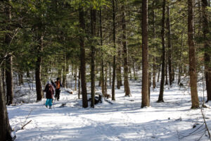 The hike on Sunday 10th March 2024 will follow a section of the main path of the Finger Lakes Trail in Urbana, just south of Hammondsport. It’s an easy hike of about 3.5 miles, and it follows the rim of … Continue reading | ||||||
| Lehigh Valley Trail Hike or Bike in Rush, NY 2:00 pm Lehigh Valley Trail Hike or Bike in Rush, NY @ Stevens-Connor Lehigh Valley Lodge Mar 17 @ 2:00 pm – 4:00 pm  Hike or Bike the Lehigh Valley Trail in Rush, NY Sunday March 17, 2024 @ 2:00pm EDT The Hike Come join us for a leisurely hike or bike along the Lehigh Valley Trail. This approximately 15-mile trail is located in … Continue reading | ||||||
| Pancakes, Bluebirds and Monkeys 12:00 pm Pancakes, Bluebirds and Monkeys @ MaryFrances Bluebird Haven Mar 24 @ 12:00 pm – 4:00 pm  Join us to celebrate NY Maple Syrup with a Pancake lunch at Stoney Ridge Farms in Farmington, NY, followed by a hike through Victor parks to burn off any excess calories. Pancake lovers will meet inside the Pancake tent at … Continue reading | ||||||
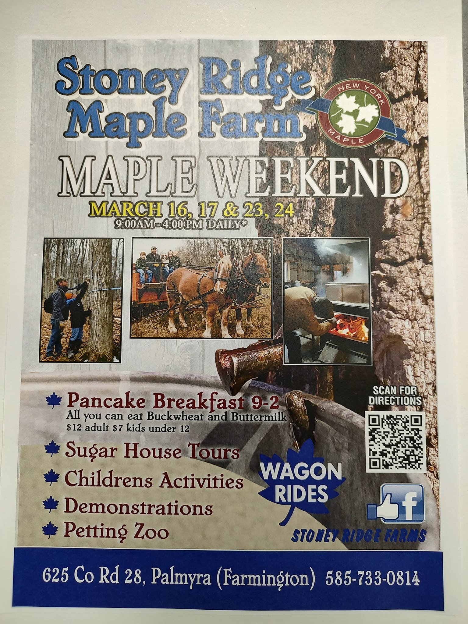 Pancake lovers will meet inside the Pancake tent at 12:00. Pancakes are $12 and are all you can eat. Included is syrup and butter for the pancakes, plus bacon or sausage and juice and coffee. While you are there, take a tour of the Sugar House to learn more about the process of making syrup and meet the owners Melinda and Chris Rodas. Pancakes are available until 2:00.
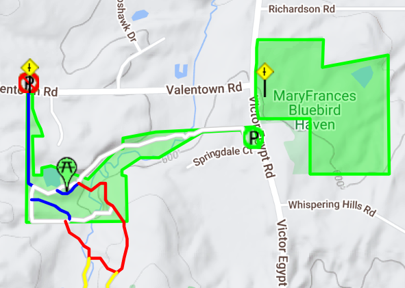 The Climbers will head south about 500ft along Victor Egypt Rd to the entrance to Monkey Run trails. These trails follow the White Brook creek and go up and down the small hills around the creek. Climbers will start on the White trail that passes behind several homes on Springdale Ct. We will turn left onto the Red Trail and follow it to a cleared route for a pipeline. Crossing the pipeline takes us to the yellow trail. From there we will loop back to the red trail (left turn on Red) and the to a left turn on the white trail. We will continue past a Blue intersection to the right and a Blue intersection to the left (which goes out to Valentown Rd). At the next blue trail, we will go right for a short side trail up to a picnic table, and then back to the white trail. From there, stay on the white trail heading east back to the entrance. From there, walk back up the Victor Egypt Rd (each hike should watch for traffic when crossing) to a trail heading south from the MaryFrances parking area. Stay on this perimeter trail around the park. The trail is close to the park boundary, so you will see posted signs. As usual, stay on the trail and quietly say thank-you to landowners when the trail wonders onto the adjacent land.
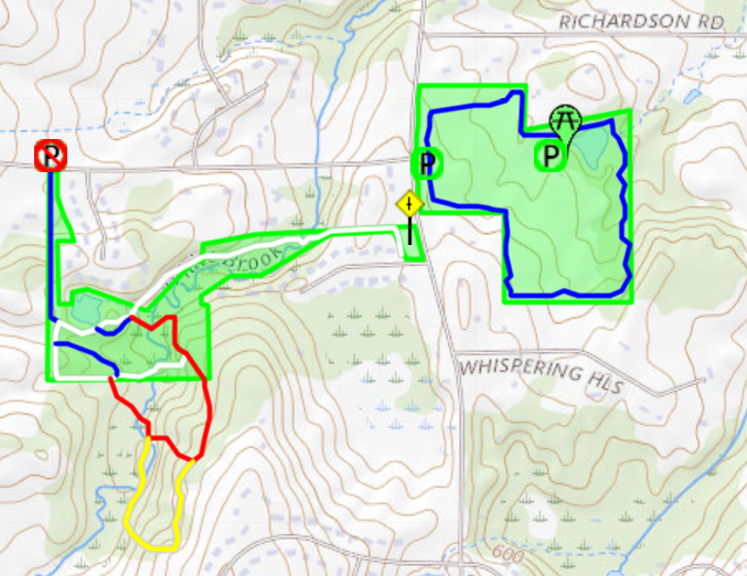 The Naturalists will follow the Perimeter Trail* (Blue) around the MaryFrances Bluebird Haven. If time permits, they will walk from the parking area down to the lodge and pond.
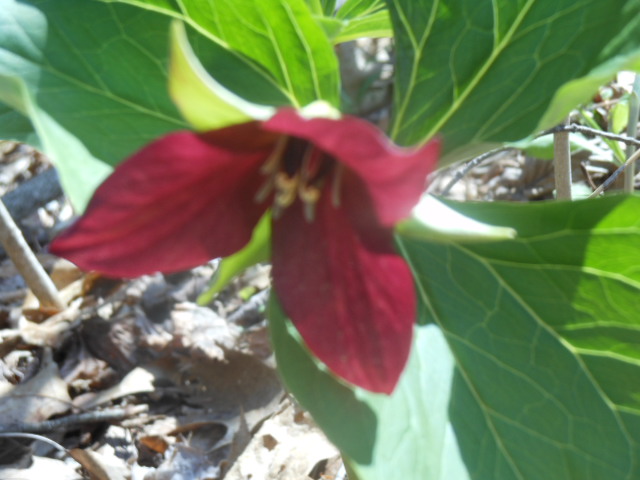
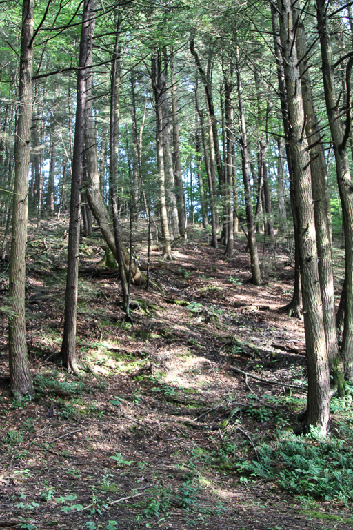
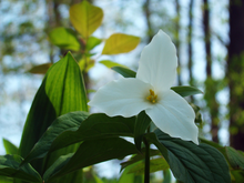 This Sunday, we’re returning to Sonyea State Forest in Livingston County, to hike along the Keshequa Creek and enjoy early spring flowers.
We will meet at 1:45pm at the gate that marks the head of the Keshequa Creek Falls Trail about 2.7 miles from the beginning of Union Corners Rd. See directions below.
All hikers will walk around the gate to a well groomed trail the heads down a steep hill to the creek. Be careful walking down, and on the way back you will want to take your time climbing this hill. But the hill is not long and most of the rest of the trail is along the old Genesee Valley Canal and railroad bed.
Our hike will take us to the western side of the forest, where we will encounter the gorge along Keshequa Creek. Within the gorge, we will see remains of the Genesee Canal and a major branch of the Pennsylvania Railroad, as well as rapids and falls along the creek.
![]() After the hike, we will enjoy an April weather picnic in the woods. Bring a dish to pass, or make a donation. We will select a clear area so, bring folding chairs, and a table, if you have one. There are no washroom facilities, not even portable ones, but lots of trees. If the day should turn out to be a rainy one, we will return to the Sunrise, in Dansville.
After the hike, we will enjoy an April weather picnic in the woods. Bring a dish to pass, or make a donation. We will select a clear area so, bring folding chairs, and a table, if you have one. There are no washroom facilities, not even portable ones, but lots of trees. If the day should turn out to be a rainy one, we will return to the Sunrise, in Dansville.
Directions: Please note: Directions on Google Maps from Springwater takes you on NY 36 North to Craig Rd up through the Groveland Correctional Facility. This road is closed to cars, although walkers and bikers are allowed to use it as part of the Genesee Valley Greenway trail.. This is not a good way to get to our hike. Please follow the directions below.
From exit 6 on 390, turn south on NY 36. Then, take the first right onto CR 72, aka Presbyterian Rd. Follow it for 3.7 miles, bearing right at the intersection with CR 11, to Union Corners Rd. Turn right here and keep going for 2.7 miles,, till you see the gate. Union Corners Rd is unpaved, with potholes, making for slow going so, consider this in planning your travel time. Turn around at the gate and park on either side of the road.
From Springwater: Take NY 15 west from the flashing light. At the top of the hill (1.5 mi), turn left onto Liberty Pole Rd.(CR 38). Continue for 8.1 miles as the road number changes from CR 38 to CR 1A to CR 1. Turn left onto NY 63 S. In just 0.3 miles take the first right onto N 258. In 1.9 miles, continue straight across NY 36 and onto CR 72 (Presbyterian Rd). Follow the directions above to the state forest.
From Naples. Follow NY 21 S to Wayland. At the first light, turn left to stay on NY 21. In 1.8 miles south of Wayland, turn right on I-390 N. In 16 miles, take Exit 6. Turn right onto NY 36. Follow the directions above.
From Rochester: take 390 south to the Sonyea exit.Turn left onto Route 36 and drive a short distance then turn right on to county road 72. Drive a few miles and turn right onto Union Corners Road. Drive a couple of miles where you will enter the Sonyea State Forest. Drive about half a mile in until you reach the parking area. There is some logging going on so the road is a little bumpy but passable.
From Dansville: and points east, take Route 36 north toward Sonyea. Turn left onto CR 72. From there follow the directions above.

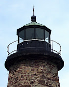
Tour of Charlotte Genesee Lighthouse and Hike or Bike Genesee Riverway Trail
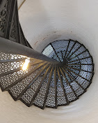
A special treat has been planned for this hike date! We have been invited to tour the Charlotte Genesee Lighthouse BEFORE our regular scheduled hike time. For those interested in the tour, you will need to RSVP Kelly Rell (kellrell@verizon.net) NO LATER than FRIDAY 4/12/24 by 10AM so that the Lighthouse can have enough tour guides for the group. Plan on an hour for the lighthouse and home tour.
Please plan to arrive by 12:45pm for the tour.
Hike:
We will meet at Charlotte Genesee Lighthouse (in the parking lot of the Holy Cross Roman Catholic Church) at 1:45pm for our hike or bike to Turning Point Park.
Cyclists: will follow the Genesee Riverway Trail down to Turning Point Park and beyond doing a 1 hour loop and return.
Climbers: After climbing the lighthouse steps they will follow the Genesee Riverway Trail the 2.2 miles to Turning Point Park and return. If time allows they can add a walk towards Lake Ontario Park.
Naturalists/Tourists: Will follow the Genesee Riverway Trail for a 1 hour loop and return.
PARKING: Parking for the Lighthouse shares the lot with Holy Cross Roman Catholic Church at 4492 Lake Avenue, Rochester, NY 14612. Please use the address of the church for your GPS.
Social:
Will be held at the Hose 22 Firehouse Grill, 56 Stutson Street, Rochester, NY 14612
Directions to Social: Turn left onto Lake Avenue out of the Church parking lot. Go 2 blocks and turn into parking lot for Hose 22 Firehouse. You can enter off of Lake Avenue or by turning left onto Stutson St. You can also leave your car at the church lot and walk down to the social!

Come join us for a hike in Sandy Bottom Park and its adjacent creek, or a bike ride around Honeoye Lake!
We will meet at 1:45pm at the parking area of Jack Evans Drive at Sandy Bottom Park, (which is located at the northwest corner of Honeoye Lake) off County Road 36 (West Lake Road), about .4 mile from Route 20A/Main Street Honeoye.
Hikers will explore the nature trails and wetlands of Sandy Bottom Park.
Cyclists will circumnavigate the lake counter clockwise, first heading south on County Road 36 for about 8 miles to the intersection with East Lake Road, then heading north along the east side of the Honeoye Valley. At about the 12 mile point those looking for a breather may visit the Honeoye South Boat Launch for a stop (with rest room) by the lake. Continue north on East Lake Road to Route 20A (Main Street Honeoye) and return to the start by Main Street and West Lake Road. Total distance is about 17 miles of gently rolling terrain, with the biggest climb near the start. An alternate course is available for those looking for a shorter and easier ride of about 12 miles; this will circle the lake part way going in the other direction, through Honeoye and down East Lake Road to the South Boat Launch and back. Cyclists may go at their own speed; please bring plenty of water. Bike helmets are required.
Social: Please join us after the workouts at the Bird House Brewery, 8716 Main St, Honeoye, NY 14471. For menu see: https://commerce.arryved.com/location/BeNKYUPu/modality/pickup
Directions:
From Springwater: Head north to Route 20A in Hemlock. Turn east on 20A. Turn south on County Road 36 (west Lake Road) at the red light intersection. Go 0.4 miles to Jack Evans Drive, and park in the large parking lot next to the ball field.
From Naples: Go north on County Road 36, and right on Jack Evans Drive just before reaching Honeoye Village.
From the east (Bristol, Canandaigua, etc): Take Rte 64 south to Rte 20A, make right onto 20A, left onto West Lake Road at the Honeoye traffic light, left on Jack Evans Drive.
From the west (Hemlock, Livonia, etc): Take Rte 15A to Route 20A, make left onto 20A, right onto West Lake Road, left on Jack Evans Drive.
Please join us this Sunday for one of our favorite hikes not far from Springwater!
A few years ago New York State acquired several new parcels of land to the south of Harriet Hollister Spencer Park, linked to the main park by an established snowmobile trail called C4. In the past, we’ve hiked the section of the C4 trail closest to the main park, and this Sunday we will hike from the parking lot, following Ruthies trail, to Chalet trail to C4 trail. We will follow C4 to a point where we will turn onto a old single track hiking trail (red dashed) that crosses the “Sidewinder” trail through the south east section of the park. we’ll follow this around and return back to the parking lot via the single track trail (red dash trail) which runs parallel with the overlook road.
Wear proper clothing according to prevailing weather conditions . As always, bring water, poles, and good hiking footwear. The trail is gently rolling – no especially steep sections.
Optional Social: Please join us at the Birdhouse Brewing Company in Honeoye – 8716 Main Street, just east of the traffic light, for craft beer and pub food
Directions:
From Springwater and Wayland – take Route 15A North from Springwater, turning right on Wheaton Hill Road. Take a left on Canadice Road (County Road 42), forking to the right when County Road 42 divides off from Canadice Lake Road. Make the next right, on Tibbals Road (formerly Town Line Road). In 1.0 miles, Take the first left onto Ross Rd. At the stop sign (2.7 miles), take a sharp right onto Canadice Hill Rd. The parking lot will be on the left in 0.8 miles..
From Rochester or Canandaigua – go to Honeoye, and follow Route 21A (Main St. Honeoye) west toward Hemlock. About a mile out of Honeoye turn left on County Road 37. Follow County Road 37 until it makes a 90 degrees turn to the right across from the Canadice Methodist Church; at this point go straight onto Canadice Hill Road instead of County Road 37. Continue straight on Canadice Hill Road, taking the left fork at Ross Road, The parking lot will be on the left in 0.8 miles..
Come join us at Mertensia Park in Farmington to see one of the area’s most reliable spots for enjoying Virginia Bluebells! May is traditionally the peak time to see these blue eyed beauties growing wild in the woods along Mud Creek.
Our hike or bike will begin at 2:00 pm from Mertensia Park (1390-1394 Mertensia Road Farmington, NY 14425). Please plan to arrive by 1:45pm (there is plenty of parking at the park).
Hikers: will explore a lovely trail through the park woods, and then head west along the Auburn Trail toward Victor, turning around to return at their discretion. Mertensia Park Trail is a 2.1 mile (4,500-step) route with an elevation gain of about 173.8 ft and is rated as easy. This is a moderately paced hike on level, well maintained trails.
Bikers: After a brief trip down to the stream to enjoy the Mertensias, the cyclists will head west along the Auburn Trail, through Victor, under the Thruway and on to the trail’s end at Woolston Road, the southwest entrance to Powder Mills Park. Total distance is 18 miles, but there are plenty of spots to turn around if you want a shorter ride. The multi-use trail is wide and a well-maintained stone dust surface, with well-marked road crossings and a few short detours onto the surrounding roads.
Social: After the hike we will gather at Eddie O’Briens Grille and Bar located at 5975 NY-96 Farmington, NY 14425. For more information about the restaurant visit eddieobriensgrille.com
Directions to the site:
From Springwater: Follow Route 15A north to Honeoye Falls, turning right on West Main Street just west of the Village. At the center of Honeoye Falls, turn right at the traffic light on East Street, which becomes Boughton Hill Road. Follow Boughton Hill Road 11.6 miles, passing Ganondagan. After East Victor Road, make a left on Mertensia Road. Mertensia Park is on your left, just over the hill.
From Rochester: Take Route 490 and the NYS Thruway to Exit 44, Farmington. Go 1.4 mile south on Route 332 and turn right on Route 96. In another .4 miles turn left on Mertensia Road. Mertensia Park entrance will be in .6 miles on your right.
From Honeoye or points along Routes 5 & 20 East or West: Head toward Bloomfield and go north on Route 444 toward Victor. At Boughton Hill Road, go right for 2.3 miles and take a left on Mertensia Road. Park will be on your left in .1 mile.
This Sunday we will hike the Finger Lakes Trail (FLT) starting at the Mt. Morris Dam and Visitors Center Parking Lot, as well as the Wildlife Loop Trail within the Dam property. We expect to enjoy the start of spring colors and, as we follow the east rim of the Letch worth gorge, the spectacular views of the gorge and Genesee River below.
The Wildlife Loop trail within the dam property is beautiful in its own right, with forest and grassy fields.
Three levels of hiking are planned – “Climbers”, “Tourist, and Naturalists”.
The Tourists will hike south on the yellow blazed (FLT) trail along the rim of the gorge, jogging east slightly away from the river across a boardwalk through a small wet area, stop at Hogsback Overlook to view the Hogsback formation of the river gorge, continue on the trail and after hiking 1 hour, turning around to head back. On the way back, we will follow the same yellow blazes but take the alternate orange blazed trail along the rim of the gorge which joins back up with the yellow trail, back to the parking lot. Total hike is 3.25 miles. Tourists may wish to walk the “Wildlife Loop”, once back to the parking lot.
The Naturalists may wish to walk the “Wildlife Loop” that starts to the right of the visitors center.
The Climbers who want a longer hike will carpool down to Lorenz Park in the village and pick up the Finger Lakes Trail and follow the yellow blaze markers south back up the gorge to the dam.
The Hike Assembly Point:
The Visitors Center will be closed. However, there is a bathroom adjacent to the parking lot that may be open on the day of the hike. All hikers will begin the hike at the Mt. Morris Dam Visitor Center Parking Lot. The trail access is at the west end of the parking lot (to your left as you face the gorge).
Social:
After the hike, all are welcome to gather at the larger pavilion located adjacent to the parking lot. Bring a dish to pass or a donation to the club fund would be appreciated, drink, and a chair.
Directions:
The Mt Morris Dam Visitor Center is about 45 minutes from Springwater, so please plan ahead. If you have a GPS, try entering Mt Morris Dam as your destination. Or enter Damsite Rd or 6103 Visitor Center Rd, Mt Morris.
From Springwater: Take Rt 15N and then left on Liberty Pole Rd. Stay on that road all the way to Rt63. There, take a left, and a quick right, onto Rt 258. At Rt 36, take a right and proceed to Mt. Morris. Turn left onto NY-408 South.
From Wayland: you can take I-390 north to exit 7. Turn left at the exit on NY-408 S to Mt. Morris. NY-408 goes left at Main St, then right on Chapel St.
From Hemlock and Honeoye: follow 20A West through Livonia and Lakeville to 390S. Exit at exit 7 NY 408 S to Mt Morris. Stay on 408 through Mt Morris.
From Rochester: Take I-390S to Exit 7 NY 408S. Stay on Rt 408 through Mt Morris.
From NY 408 in Mt Morris: Go south on 408 for 1.8 miles to Visitor Center Rd. Turn right at the Visitor Center Road and follow the road all the way to the Dam and Visitor Center Parking lot.
Exploring the Bog Nature Trail in it’s Spring Glory!
We are revisiting this trail in search of spring wildflowers! This hike will be on a section of the Bristol Hills Branch of the Finger Lakes Trail (Map B3) and include the Bog Nature Trail Loop. Most of the hike is in Urbana State Forest, Steuben County. The Nature Trail has been well documented in a 2003 Guide Book full of information on site history and unusual plants to be found here at different times of year. Read or download the guidebook or map (p. 3) at Huckleberry Bog.
We will start from the trailhead on Bean Station Road, meeting at 1:45 for a 2 PM start. Following the orange blazes, we will head south past the restored Covell Cemetery and the Evangeline Shelter then climb steadily uphill through a hemlock and oak woods to the state forest and onto the top of the plateau. Tourists and Naturalists will go as far as the bog observation deck and then back track to Bean Station Road (~3miles total). Climbers will continue on past the overlook and follow the Bog Nature Trail Loop clockwise returning to Bean Station Road by way of the blue blazed side trail and then the main trail (~4.5 miles total).
Social – Will be held at 70 N Main Street, Prattsburgh, Kelly’s family home. Follow Bean Station Rd back to Route 53 and head North on Route 53 back to Prattsburgh. At the blinking light in Prattsburgh, Chapel St, turn right. Follow to stop sign and turn left onto North Main Street. The house is a 2 story blue/grey colonial with a large red barn out back. We will meet on the covered patio for a dish to pass (left side of the house behind fencing).
As a bonus you may have a tour of the horse carriage collection in the barn and/or the restored vintage Farmall Tractors!
Directions to Meeting Location
From Springwater: Head south on NY 15 to Wayland. Turn left onto NY 21, Turn left in N Cohocton to stay on 21 into Naples. Turn right onto NY- 53. Stay on NY-53 through Prattsburgh. Follow the directions below.
From Prattsburgh, take NY- 53 South for 2.6 miles to Bean Station Road. Turn east on Bean Station Road at the site of a large white warehouse for onions. Go 2.6 miles to the yellow trailhead sign on the right (south) side of the road at a little footbridge over the roadside ditch. Park on the north side of the road – this is important as this is a narrow road and parking on both sides could cause a traffic hazard.
From Geneseo and Dansville: Take I-390 South to I-86East. In 1 mile, take exit 37 for NY-53. Turn left onto NY-53 and head north for 8.9 miles. Turn right onto Bean Station Road. Continue with the directions From Prattsburgh.
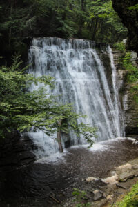
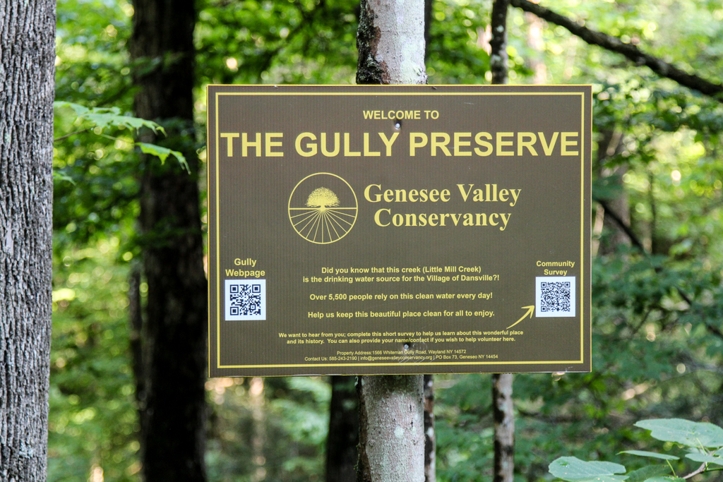
Whiteman Gully is a unique place – a pristine Finger Lakes gully not much touched by any organized hand. It was privately held until a couple of years, when it was bequeathed to the Genesee Valley Nature Conservancy.
This is a different hike to our usual long walk; it will be a hike of exploration along trails which are not long, but unimproved and requiring care; we will wander around a small but very scenic patch of land. There are 3 trails to explore on both sides of Whiteman Gully Road. There have been few “improvements” to suit casual walkers on this property; if there has been rain recently the paths will be muddy but the waterfalls and the stream more impressive. To get a good view of the waterfall on the south side of the preserve there is a stream crossing on stepping stones to be dealt with, and the section of the trail to get a view of the waterfall is short but steep; this pattern is likely to be repeated on other trails that we explore. There are several waterfalls and a chute on the north side of Whiteman road, and further waterfalls can be seen which are probably beyond the boundary of the preserve.
The gully does not appear to have been farmed or logged and the trees are big and old.
The Meeting Place
We will meet at the point where Whiteman Gully Road in Wayland crosses the stream of the gully (42.55731, -77.65159). There is adequate roadside parking on Whiteman Gully Road. First we will explore the trail to the north west and the gully around the waterfall. We will then return to the meeting point and explore the trail upstream and finally the trail the the north west on the opposite side of the stream to the first trail that we followed.
All hikers will walk in just one group on this hike, and hiking alone is definitely to be avoided given the uncertainty of the trail conditions.
Equipment
Gum boots or high waterproof boots and two walking poles are strongly recommended for the stream crossing, especially if there has been rain, and the poles are generally helpful on muddy and steep ground.
We will bring a rope to help on the steep section of the trail near the waterfall
Directions:
From Naples: Come into Wayland on Rt 21 from the east. Continue through the two traffic lights when the road becomes Rt. 63 to Dansville. Passing the the Wayland school on the left, continue for about 3 miles to Whiteman Gully Road on the right. Turn right and follow the road for about half a mile; the road turns into dirt and drops downhill; the gully is at the bottom of the hill where the stream is marked by barriers along the side of the bridge.
From Springwater: Come into Wayland on Rt 15 and turn west on to Rt. 21, then follow the directions as from Naples.
From Dansville: Drive towards Wayland on Rt 63 and take the second Whiteman Gully Road left – Whiteman Gully Road follows an arc with both ends on Rt. 63 – then follow the road for about half a mile. The road turns into dirt and drops downhill; the gully is at the bottom of the hill where the stream is marked by barriers along the side of the bridge.
The Social
The social will be at the Sunrise Family Restaurant in Dansville, NY.
Looking for brochure.or mailing list so I can receive it in the mail.
Nothing opens up for mailing list.
There’s all kinds of very bizarre ads and post for viagra and other drugs above on calender page.
Please let me know if there’s a brochure available