
Hikes led by Springwater Trails are generally held on Sunday afternoons and appear in this calendar in green.
| Sun | Mon | Tue | Wed | Thu | Fri | Sat |
|---|---|---|---|---|---|---|
| Keshequa Creek Walk 2:00 pm Keshequa Creek Walk @ Sonyea State Forest May 7 @ 2:00 pm – 4:00 pm 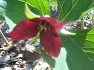 This Sunday, we’re returning to Sonyea State Forest in Livingston County, to hike along the Keshequa Creek. We will take time to enjoy the spring flowers. We will meet at 2 PM at the gate that marks the head of … Continue reading | ||||||
| Genesee Gorge, Mt Morris Dam and Lorenz Park 2:00 pm Genesee Gorge, Mt Morris Dam and Lorenz Park @ Mount Morris Dam Area May 14 @ 2:00 pm – 4:00 pm This Sunday we will hike the Finger Lakes Trail (FLT) starting at the Mt. Morris Dam and Visitors Center Parking Lot, as well as the Wildlife Loop Trail within the Dam property. We expect to enjoy the start of spring … Continue reading | ||||||
| Onanda Park, Town of Canandaigua 2:00 pm Onanda Park, Town of Canandaigua @ Ononda Upland Parking May 21 @ 2:00 pm – 4:00 pm  Join the group Sunday May 21 from 2-4PM for a lakeview hike around Onanda Park in the Town of Canandaigua. This park was originally a YWCA camp at the turn of the 20th century and was purchased in 1989 through … Continue reading | ||||||
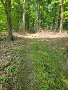
| Stid Hill Hike 2:00 pm Stid Hill Hike @ North Entrance on Rt. 64 May 28 @ 2:00 pm – 4:00 pm 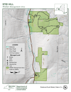 The Stid Hill Multiple Use Area is a 847 acre tract of land situated in the townships of Bristol and South Bristol in Ontario County. It is bounded by Route 64 on the west and Dugway Road on the north. … Continue reading |
The Stid Hill Multiple Use Area is a 847 acre tract of land situated in the townships of Bristol and South Bristol in Ontario County. It is bounded by Route 64 on the west and Dugway Road on the north. Ganargua Creek, better known as Mud Creek, flows along Route 64. At one time, Stid Hill was productive sheep and cattle grazing land. Today the grazing has been eliminated. The mixture of steep hills, ravines, gullies, gorges, woods, and open areas create scenic vistas and also provide varied wildlife habitats.
Sunday May 28, 2023 we will all meet at the Stid Hill MUA parking area on Rt. 64 at 1:45pm. At this meeting point we will divide into groups. Climbers will carpool to Dugway Rd. and hike back down to Rt. 64. The Tourists and Naturalists will follow the trails from this access point on Rt. 64. The ground is uneven so you may want to bring poles. There may also be very wet and muddy spots along the trail so waterproof hiking shoes or boots would be recommended.
The Meeting Place
We will all meet at the Stid Hill MUA parking area on Rt. 64 at 1:45pm. This parking area is for the northern portion of the Stid Hill area. It is after Bristol Mountain ski area if coming from Naples, and after Dugway Rd if coming from 5&20 or 20A.
Getting There
Route 64 runs north-south, so there are only two directions of approach.
From the north, (Honeoye and Bloomfield) starting at Route 5 & 20 in Bloomfield, come down Route 64, past Bristol Center and CR32. 4.8 miles past the intersection with 20A, the parking area will be on your left. If you reach Bristol Mountain Ski Area you have gone too far.
From the south, starting at Bristol Springs head north on Route 64 past Bristol Mountain Ski Area for 1.4 miles, and the big wooden sign that says Stid Hill, you will then see the parking area on your right. If you come to Dugway Road or Bristol Center you’ve come too far north.
From Springwater, Google Maps recommends heading north to 20A through Honeoye, then south on 64 for 4.8 miles. The parking area will be on your left.
The Social
Will be at Lock Stock and Barrel on Route 64 just north of Bristol Mountain and south of the Stid Hill Hike parking lot.
Our hike Sunday June 4, 2023, starts at 4pm (please arrive by 3:45 to carpool to our starting point). This is a one-way hike around farm fields, following trails through sections of woodlands, continuing along paths beside the Cohocton River to the Old Erie Railroad bed ending in the Hamlet of Atlanta. We will meet at our ending point in Atlanta. Across the street from the E J Cottrell Library, 3 Beecher Street, Atlanta. Look for the Springwater Trail’s parking sign.
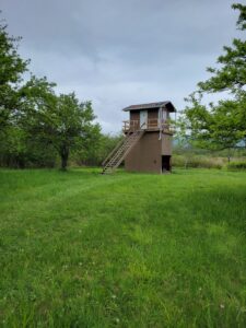 Most of this is private land except for portions of the Railroad beds that the DEC have for fishing access. We will drop the Naturalist off on Parks Road to begin their flat hike down the Old Erie Railroad Bed for 1.5 miles. If they finish before the rest of the group, they can tour the Clark property which is forever in a wetland reserve. There are trails throughout the property that you can follow. Check out the Birdhouse for a bird’s view of the river, hiking paths and wildlife. If by chance you prefer to just tour the wetlands that is also an option by starting at the parking lot, walking a short distance up the Old Erie Railroad bed and entering the reserve. The first entrance on your right will have trails throughout the reserve. The 2nd entrance will be the home of the Birdhouse which you are welcome to climb and see the views.
The Tourists and Climbers will start downhill together before the Tourists change directions through a short uphill climb through a sugarbush to the crossing of the Cohocton River. They will then work their way around the headlands to the Old Erie Railroad bed, flat terrain, for a total of 3.25 miles.
The Climbers will head off for an up and down trail through the woods to the flat path along the Cohocton River. Once they cross the river, they will follow the headlands to the Old Erie Railroad bed for a total of 4.25 miles.
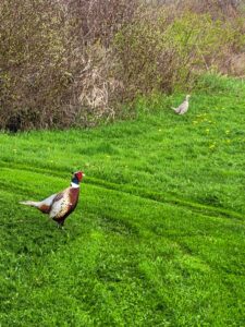
We might even be lucky to see Fred and Francis down by the river.
DIRECTIONS
From Springwater: take Route 15S to Wayland for 4.9 miles. At the light in Wayland turn left onto Route 21N, drive 5.9 miles to Beecher Street. Continue on Beecher Street for .5 miles with parking on the right. Watch for the Springwater Trail sign.
From Naples: take Route 21S to North Cohocton. Turn right to stay on 21S. Go .8 miles turn left onto Beecher Street. Continue on Beecher Street for .5 miles with parking on the right. Watch for the Springwater Trail sign.
The Social will be at the Mt. View Inn at 34 Main Street in Atlanta.
Please join us for a hike on Robs Trail. For this hike, we will take advantage of portions of Rob’s Trail on both the Hemlock and the Canadice sides of route 15A. There are two parking lots for Rob’s trail at the top of Bald Hill, so pay attention and meet at the parking lot that is located on Old Bald Hill Rd South. Don’t come to the parking lot directly on Rt 15A. See directions below.
The Tourists and Climbers
The Naturalists will head east from the parking lot and will explore the Rob’s Trail loop around the top loop of Rob’s trail. At about the mid-point, the is a bench and a branch trail that heads down the hill to Canadice Lake. On this hike, the Naturalists won’t take the steep trail down the hill, but will continue straight around the loop and back to the cars.
Following the hike, please join us for a pot-luck social at Hemlock Park at the North end of Hemlock Lake. Bring a dish to pass and your own beverage. Or donate $5 to the social fund.
For a more detailed description of Rob’s trail, check out their website.
Directions to the trailhead:
From Springwater: Take Rt 15A north. In 5.9 miles north from the flashing light in Springwater, take a sharp right turn onto Old Bald Hill Rd S. The parking lot is on the left almost immediately. Just a reminder – don’t park on the left side of Rt 15A because we aren’t meeting there.
From Hemlock: Take Rt 15A south. At 4.9 miles south of the 20A/15A intersection south of Hemlock, take a slight left onto Old Bald Hill Rd S. The parking lot is on the left almost immediately. Just a reminder – don’t park on the right side of Rt 15A because we aren’t meeting there.
From Honeoye. Take US-20A west. Turn left onto NY 15A about 4 miles past CR 37. In 4.9 miles south of the 20A/15A intersection take a slight left onto Old Bald Hill Rd S. The parking lot is on the left almost immediately. Just a reminder – don’t park on the right side of Rt 15A because we aren’t meeting there.
From Canandaigua: Take Bristol St from Main St in Canandaigua to the intersection of US 20 and NY 21. Continue straight across US 20 onto NY 21. Continue straight again onto CR 32. In 3.9 miles from US 20, take a slight right onto Fisher Hill Rd, then (after 0.4 mi) a left onto Vincent Hill Rd. In 1.9 miles turn left onto US 20A. Turn right to stay on US 20A, through Honeoye to a left onto NY 15A. In 4.9 miles south of the 20A/15A intersection take a slight left onto Old Bald Hill Rd S. The parking lot is on the left almost immediately. Just a reminder – don’t park on the right side of Rt 15A because we aren’t meeting there.
Direction to the Social from Old Bald Hill Rd S. Turn right out of the parking lot, then right onto NY 15A. In 4.2 Miles, turn left onto Rix Hill Rd. The park is the third left in 0.1 miles.
SUNDAY WEATHER UPDATE: The forecast is improving, with the chance of rain rising from 25% to 50% between 2 and 4 and no chance of thuderstorms. If you feel like paddling under these conditions, come on over. The hike will proceed rain or shine. Everyone meet at LaSalle’s Landing Park. Questions? Call Saralinda at 585-705-1865.
This event has options for both paddlers and hikers, with a common meeting place at La Salle’s Landing Park, 1080 Empire Blvd. Penfield, just across from Bay Creek Paddling Center. Afterwards both groups will gather for our social at the home of Gene and Georgia Binder at 1855 Westfall Road in Brighton. PLEASE NOTE THIS EVENT STARTS AT 2PM, TO ACCOMMODATE ANYONE RENTING A BOAT FROM BAY CREEK PADDLING, WHICH CLOSES AT 5.
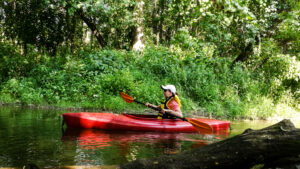
Boaters: Join us for the first SWT paddle of the season, in Irondequoit Creek. Bring your own kayak or canoe to the launch site, or rent one from Bay Creek Paddling Center, just across Empire Blvd at #1099 and launch from their dock directly into the creek. See https://www.baycreek.com/rentals for information and pricing on their rentals, which are by the hour and first-come first-served. Please arrive between 1:30 and 1:45 to unload your boat or arrange your rental. Irondequoit Creek meanders southward from the launch site through a peaceful wetland between Irondequoit Bay and Ellison Park. You can enjoy quiet waters and abundant bird life along the creek, going as far as the Browncroft Blvd Bridge and back, or explore the shoreline at the south end of Irondequoit Bay. We will not be in a single group, so please observe the boat buddy system and keep another SWT boat within sight as you paddle.
Hikers will explore one of Monroe County’s most interesting but least well known parks. Lucien Morin Park abuts the wetlands surrounding Irondequoit Creek, and contains some low but rugged hills and valleys, similar to nearby the Abe Lincoln and Durand Eastman Parks. In addition the property was used for target practice by the National Guard back in the mid 20th century, and has some interesting surviving site structures left over from the military use.
Hikers will gather at 2 PM at LsSalle’s Landing and carpool across Empire Blvd to the Lucien Moran trailhead parking area. All hikers will follow the White Trail and dirt road along the wetland (west) side of the park, heading for the gazebo where the officer used to oversee the shooting operations. Naturalists can return to the start from there for a relatively level and easy hike. Climbers and those looking for a more rigorous hike may continue south to loop around to the west and return overlooking the wetland.
Social: Please join us afterward for a dish-to-pass social at Gene and Georgia’s home at 1855 Westfall Road, Brighton, at the southeast corner of Westfall and Fairhill Drive. See directions and parking instructions below. Bring your own beverage and a folding chair along with assorted goodies, or donate $5 and help yourself. Bring a card table too if you have one.
Directions to LaSalle’s Landing:
Take your favorite route toward Rochester, via route 15, 15A, 390, or 490. When you reach the Outer Loop (390/590), go north on Route 590 toward Irondequoit. About 2 miles after passing through the 490 intersection, take the Empire Boulevard/404 exit. Make a right on Empire Blvd, and go down the hill toward the bay. LaSalle’s Landing Park will be on your left at #1080, just across from Bay Creek Paddling Center. Lucian Morin Park trailhead and parking lot will be on your right at #1135, just past the former McGregor’s.
Directions to the Social 185 Westfall:
Head back to the west on Empire Blvd. You may take 590 south back to the Monroe Avenue (Route 31) exit, then make a left on Monroe and an immediate right on Westfall, proceeding to Fairhill Drive, the sixth left off Westfall. Turn around on Fairhill and park on the west side shoulder, next to 1855 Westfall, the house on the corner.
Simpler and more direct route: Head back to the west on Empire Blvd. Before you come to the 590 ramps, turn left on Winton Road. Take Winton Road all the way to Brighton – 4.6 miles. Cross Westfall Road, then take the next left on Fairhill Drive (it’s L shaped). Follow Fairhill around to the left, and park on the right hand shoulder at the last house on the right, 1855 Westfall.
On the last Sunday before the 4th of July we will have a leisurely walk around the magnificent Maplewood Rose Garden in the northwest quadrant of Rochester, at the junction of Lake Avenue and Driving Park Avenue. Maplewood Park is one of two original parks laid out by Frederick Law Olmsted to highlight the Genesee River. There is good parking at the Rose Garden at the driving Park Avenue entrance. The link to the Rochester city web site pages for Maplewood Park is here
All groups will walk together on this hike. It is intended to be an slow, easy, relaxing afternoon in a lovely part of Rochester.
 The Hike
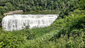
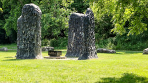
We’ll take up about an hour of the hike with walking around the avenues of roses – there are over 250 varieties on display – then we’ll walk across Driving Park Avenue to the Lower Falls Park, which surrounds the lowest waterfall on the Genesee River. The walk down to the level of the park is fairly steep, but then it’s easy walking on level pathways. This park offers superb views of the park, a sculpture installation reminiscent of a small Stonehenge and finally Rochester’s own hydroelectric plant. The hydroelectric plant is downstream of a large salient in the river which acts as a supply pond for the turbines.

The Social
For the social we’ll drive to the Genesee Brewing Company plant at High Falls, the highest and most upstream waterfall on the Genesee River in Rochester. The address is: Genesee Brew House, 25 Cataract St, Rochester, NY 14605. It is 2 miles away, going south down St. Paul Street.
Directions to the Maplewood Rose Garden
The address is Maplewood Rose Garden, 250 Maplewood Ave, Rochester, NY 14613. The first choice for getting there is to tell your GPS that this is where you want to go, and then follow instructions.
GPS isn’t always first choice; here are traditional directions:
From the South:
1: Take your favorite route to the I490 heading west – which is compass north for those of us living south of the city
2: Take exit 13 for the Inner Loop
3: Take the exit toward Downtown/St Paul St/Clinton Ave, then use the left 2 lanes to turn left onto St Paul St
4: Follow St. Paul Street until you come to Avenue E; turn left onto Avenue E
5: Continue onto Driving Park Ave. After you cross the Genesee River the road becomes Driving Park Ave; turn right shortly after the river into Maplewood Park. There’s plenty of parking there
Directions to the Social at the Genesee Brewery
The address is Genesee Brew House, 25 Cataract St, Rochester, NY 14605. Again, the first choice for getting there is to tell your GPS that this is where you want to go, and then follow instructions.
Traditional instructions are:
1: Exit the Rose Garden parking lot and turn left on to Driving Park Avenue, which turns into Avenue E across the river
2: Turn right on to St. Paul Street and continue for 1.4 miles.
3: Turn right on to Cataract Street and the brewery is a hundred yards away in front of you, overlooking the High Falls waterfall.
This Sunday we have a choice of activities, both starting from Sandy Bottom Park at the the northwest corner of Honeoye Lake – a hike in Sandy Bottom Park and its adjacent creek, or a bike ride around Honeoye Lake. While we’ve done this event for the past few years, note that our starting point and the location of our social are different this year. After the workouts we will enjoy a dish-to-pass social at the lakeshore in Sandy Bottom Park.
Everyone meets at 3:45 at the Sandy Bottom Park parking lot on Jack Evans Drive, off County Road 36 (West Lake Road), about .4 mile from Route 20A/Main Street Honeoye. Hikers will explore the nature trails and wetlands of Sandy Bottom Park. Cyclists will circumnavigate the lake counter clockwise, first heading south on County Road 36 for about 8 miles to the intersection with East Lake Road, then heading north along the east side of the Honeoye Valley. At about the 12 mile point those looking for a breather may visit the Honeoye South Boat Launch for a stop (with rest room) by the lake. Continue north on East Lake Road to Route 20A (Main Street Honeoye) and return to the start by Main Street and West Lake Road. Total distance is about 17 miles of gently rolling terrain, with the biggest climb near the start. Cyclists may go at their own speed; please bring plenty of water, and helmets are required.
Social: Please join us after the workouts for our optional dish-to pass social at the Sandy Bottom pavilion. The pavilion is to the east of the parking lot, past the Rotary Club building and next to the lake. Bring a lawn chair in case the pavilion is reserved. Bring your own beverage and favorite dish to share, or contribute $5 to our social fund. There is no long term parking near the pavilion, but there is a gravel drive you can take to the left of the Rotary Building to drop things off for the Social.
Directions:
From Springwater: Head north to Route 20A in Hemlock. Turn east on 20A. Turn south on County Road 36 (west Lake Road) at the red light intersection. Go 0.4 miles to Jack Evans Drive, and park in the large parking lot next to the ball field.
From Naples: Go north on County Road 36, and right on Jack Evans Drive just before reaching Honeoye Village.
From the east (Bristol, Canandaigua, etc): Take Rte 64 south to Rte 20A, make right onto 20A, left onto West Lake Road at the Honeoye traffic light, left on Jack Evans Drive.
From the west (Hemlock, Livonia, etc): Take Rte 15A to Route 20A, make left onto 20A, right onto West Lake Road, left on Jack Evans Drive.
Sugar Creek
Keuka Lake
 This week, Springwater Trails is offering a hike at the highest park in Ontario County and also a bike ride from that highest point down to Canandaigua Lake at Woodville.
Join us at 4:00 at the entrance to the hiking trails on the west side of Ontario Park. Bikers and hikers will all start from the parking area on the main park loop road. Hikers will follow the brown, yellow and red trails for about 3.5 miles, while the hikers will ride roads around the park loop onto Gannett Hill Rd (South) to Seman Rd and then back north to Bristol Springs and down to Woodville for 17 miles.
Following the hike and bike ride, all are welcome to join us at Brews and Brats for a refreshing social.
Details
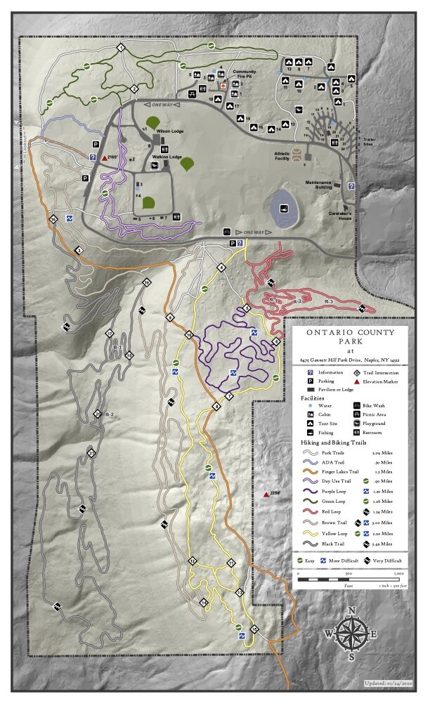
 The Hikers will follow ski trails. These trails are shared with mountain bikers in the summer. The brown trail starts off close to the road. When the brown trail turns south, we will switch to the Park Trail and then join the yellow trail headed for intersection 10. Staying on the yellow trail to the next intersection (12) we turn left and head over to intersection 11. Again, left to head back north staying on yellow. The yellow trail will cross the BHB and intersect with the purple trail before coming to intersection 6 and the red trail. We will turn right onto the red trail and will continue to turn right on intersections within the red trail until it returns to the park road. Crossing the road, we will make our way clockwise around a quarter of the pond and then across the fields (toward the radio towers) to the picnic shelters loop. There are nicely mowed trails through a Warbler nesting area. The path back to the cars branches off the shelters loop at the far corner.
Hikers wishing a shorter hike should stay to the left on the red trail trail until it gets to the road and then cross to the fields and back to the cars.
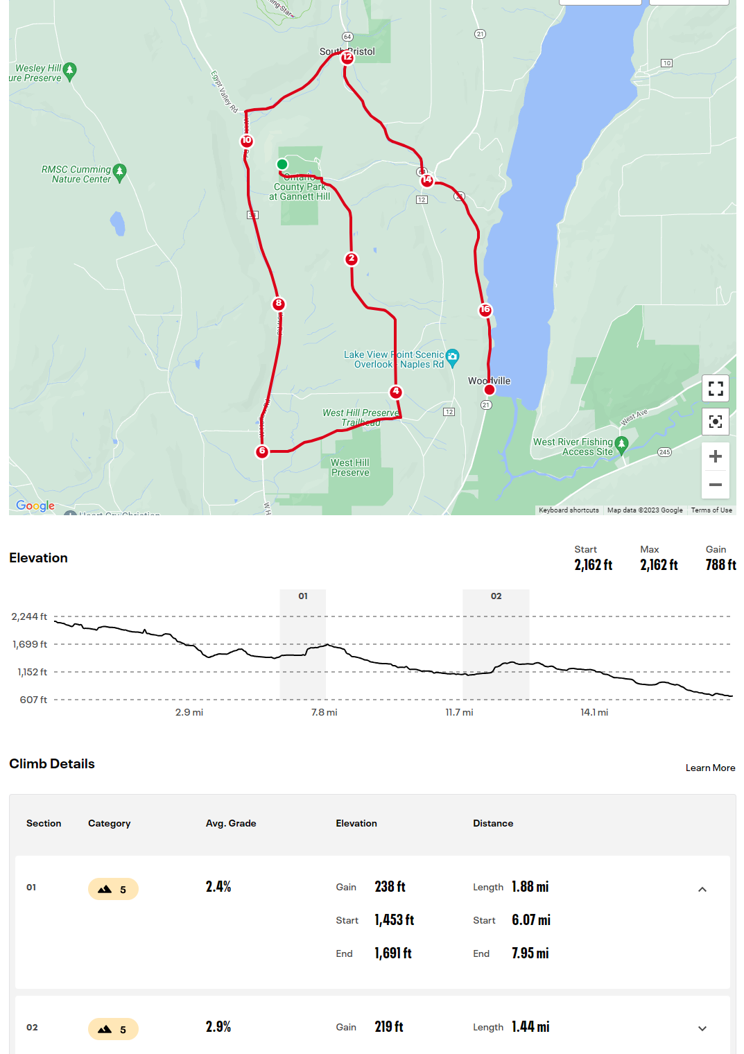 Bikers will continue from the parking area along the park road. At the first intersection, we will turn right onto Gannett Hill Rd. The next right turn will be at the stop sign for Seman Rd, where we will ride past the West Hill Preserve. We then turn right onto W Hollow Rd and will make note of the Bristol Branch crossing from the road, and the old Ski Valley ski runs on the left. There is another right onto Egypt Valley Rd, and then right onto NY 64. At mile 14, we will pass through South Bristol. Some bikers may wish to stop at Brews and Brats. Meanwhile, the remaining bikers will continue onto NY-21 and head down to Woodville, where cars will be available to bring riders back to their cars. You may want to bring a bike lock in case we have more room in the cars than for bikes.
Bring water and your own bike if you wish to bike.
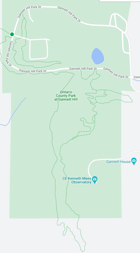
Directions: The easiest route to the park is to take NY 64 to Bristol Springs and turn west on Gannett Hill Rd. There is a sign indicating Ontario County Park. At the top of the hill turn right onto South Gannett Hill Road. The park entrance is straight ahead. Follow the park road for about .5 miles to our meeting place which is the parking area along the park road near the information kiosk at the Finger Lakes Trail trail-head. (Don’t turn off the main road into the camping areas or the picnic shelters).
Details From Springwater, Wayland and Naples: From Springwater, head south on NY-15. At the light in Wayland, turn left and follow NY-21 through Naples. Just past the village, bear left onto CR-12 (Bristol Springs Rd). In 1.9 miles, bear left onto Rhine St. Continue straight (In .6 mi, the name changes to Powell Rd and then in .3 mi to Gannett Hill Rd, and then in 3.2 miles it enters the park). Follow the road around the park for half a mile to our meeting place.
Details from Hemlock and Honeoye: From Hemlock, head south on NY-15A. Just outside of the hamlet, turn left on US-20A. Continue through Honeoye and turn right onto East Lake Road. In 0.6 mi, turn left onto CR 33 (Egypt Valley Rd.). In 6.9 miles, continue straight onto CR 34. In 1.6 miles, turn right onto NY-64. In another 1.9 miles, turn right onto Gannett Hill Rd. In 1.3 miles, turn right into the park. Follow the road around the park for half a mile to our meeting place.
Details from Canandaigua: Take US 20 west out of the city. Turn left onto Parrish St Ex. In 0.9 miles, turn left onto NY-21. Continue for 11.9 miles to the intersection with NY-64. Turn right onto NY-64 N. In 0.4 miles turn left onto Gannett Hill Rd. In 1.3 miles, turn right into the park. Follow the road around the park for half a mile to our meeting place.
 Second try!
We got rained out of this hike when it was on our July calendar, so we’re trying again with a terrific forecast this time around.
Join us Sunday the 13th for a different view of the DEC’s Hi Tor property. This time we are offering two hikes in the northern section of the Hi Tor Wildlife Management Area. Naturalists will explore the lower section of Conklin Gully near the Blue Trail Parking Area, while the Climbers and Tourists will car pool to the top and descend along the gully on the Finger Lakes Trail’s Bristol Hill Branch from Brink Hill Road to the west. Most Hi Tor hikes start out with an exhausting climb; this one is an exception – the trail follows the creek downstream for several miles before emerging on the service road down toward the Middlesex Valley. Avoiding the very steep final descent to Route 245, we will detour to the north on the Blue Trail and take in the dramatic overlooks at lower Conklin Gully before returning to the cars left at the meeting place. The total Climber hike will be about 3.5 miles with a descent of about 800 feet, but it will occupy 2 hours plus including the car pool. The Naturalist hike will stay near the original meeting point for a more leisurely trip of about 1.5 miles total, descending gently into the gully to the bridge and back, taking in overlook views of the gully and the hills beyond.
Everyone will gather at 3:45 at the Blue Trail Parking Area, off Parrish Hill Road, about a half mile up the hill from the intersection with Route 245. The car pool with Climbers/Tourists will leave at 4PM sharp, so please be on time. Trail may be muddy or wet if it’s rained recently, so we recommend waterproof and high-traction footwear, long pants and poles for the the occasional steep downhill. Also insect spray. We will need several volunteers for car pooling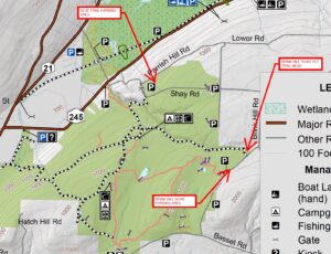 .
.
The optional dish-to-pass social afterwards will be at Naples Community Park at 8165 Route 245, where there are pavilions and rest rooms. Bring your favorite snacks, desserts, salads or entrees to share, or contribute $5 to our social fund. Bring a folding chair just in case the pavilions are reserved or full.
Directions to Meeting Place at 42.635514,-77.357383: Take your favorite route to Naples. At the intersection of Main Street Naples (Route 21) with Route 245, just opposite Bob and Ruth’s Restaurant, go north on Route 245 toward Middlesex. In 1.7 miles, take a right on Parrish Hill Road (just after the Hi-Tor Parking Area at the foot of Conklin Gully). In .5 miles you will see a dirt road on the right, near a sharp left turn. Go up the dirt road a short distance to the Blue Trail Parking Area.
Car pool to Brink Hill Road Parking Area at 42.619834, -77.330930: Return to Parrish Hill Road and go right. In about a mile and a quarter Parrish Hill Road will make a sharp U turn to the right. Continue on Parrish HIll Road another 3/4 mile and make a left on Shay Road, then a right on Brink Road. At the next intersection go right on Brink Hill Road. The parking area will be on your right in about a half mile.
Directions to Social at 42.623798, -77.385576: From Brink Hill Road, return the way you came, back down Brink, Shay and Parrish Hill Roads to Route 245. Go left towards Naples. The Community Park will be on your left, just before the DEC facility and Naples Creek.
Looking for brochure.or mailing list so I can receive it in the mail.
Nothing opens up for mailing list.
There’s all kinds of very bizarre ads and post for viagra and other drugs above on calender page.
Please let me know if there’s a brochure available