
Hikes led by Springwater Trails are generally held on Sunday afternoons and appear in this calendar in green.
| Sun | Mon | Tue | Wed | Thu | Fri | Sat |
|---|---|---|---|---|---|---|
| First Day Hike – Canadice Lake Trail 2:00 pm First Day Hike – Canadice Lake Trail @ North West Parking Lot Jan 1 @ 2:00 pm – 4:00 pm 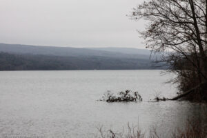 The Hike: Start the New Year the way you mean to go on – come for an inspiring hike along Canadice Lake! This is an easy, 1.8-mile each way hike along the shore of the lake; the trail is level … Continue reading | ||||||
| Wesley Hill Preserve 2:00 pm Wesley Hill Preserve @ Gulick Rd Parking Lot Jan 8 @ 2:00 pm – 4:00 pm 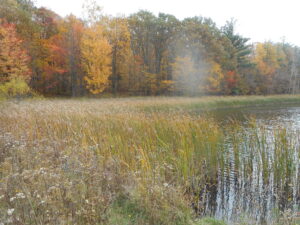 This is a change from the scheduled hike at the Hemlock lakeshore, which is rescheduled to March 5th. We’re making the calendar change to keep our distance from the Canada Goose hunting activity along the Hemlock Lake Trail, continuing through … Continue reading | ||||||
| Keuka Outlet Trail Hike 2:00 pm Keuka Outlet Trail Hike Jan 15 @ 2:00 pm – 4:00 pm  This Sunday we will hike the western half of the Keuka Lake Outlet Trail starting at Seneca Mill and walking west to Penn Yan. The whole trail follows Keuka Lake’s outlet to Seneca Lake, starting in Penn Yan and going … Continue reading | ||||||
| Honeoye Lake View Winter Hike 2:00 pm Honeoye Lake View Winter Hike Jan 22 @ 2:00 pm – 4:00 pm This Sunday we will explore the woods and fields overlooking Honeoye Lake on the west side, followed by a dish-to-pass social at the Affolter farm. Meet at 5422 County Road 37, about 2 miles south of Route 20A and 2 … Continue reading | ||||||
| Mendon Ponds Winterfest Hike/Ski 2:00 pm Mendon Ponds Winterfest Hike/Ski Jan 29 @ 2:00 pm – 4:00 pm Join us on Sunday the 29th to celebrate the season in your hiking boots or on your skis as Mondoe County sponsors the 2023 Winterfest at Mendon Ponds Park. Everyone, both hikers and skiers, will meet at the Nature Center … Continue reading |
The Hike:
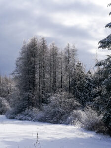
A First Day hike along Canadice Lake.
Start the New Year the way you mean to go on – come for an inspiring hike along Canadice Lake! This is an easy, 1.8-mile each way hike along the shore of the lake; the trail is level and well-maintained and the lake views are lovely. For most hikers it will be a walk along the lake for an hour or so, and then back the same way; more enthusiastic hikers can veer off on Rob’s Trail that leads over the ridge and down to Hemlock Lake – this is a moderate to hard trail with several steep uphill and downhill sections. We’ll take a roll call the day of the hike if anyone wants to walk Rob’s Trail. We’ll arrange for transport back for those who only want to walk one way. Dress appropriately for the weather, carry water and some energy food, and carry a walking pole if it helps. Leashed pets are welcome.
A First Day hike along Canadice Lake.
This is not a “routine” Sunday hike – it’s special because the hike is promoted by the NYS DEC, and is part of a larger program of First Day Hikes to encourage people to get out and experience the magnificent Sate of New York that they live in. The DEC, State Parks, and the Canal Corporation invite New Yorkers to kick off 2023 by participating in one of the many hikes being held at state parks, historic sites, wildlife areas, trails, and public lands across the Empire State. All hikers will leave with a memento of the hike and will be eligible to win an Empire Pass the allows entry to most state parks across the state.
Please note that the First Day hike this year is at 2:00pm, giving everyone a little more time to get over the night before.
The Meet-Up Location
All First Day hikers should meet at the parking area off Purcell Hill Road, Town of Canadice, Ontario County. Google Maps (leaves this website) Click here for directions.
The Social
There won’t be an organized social on this hike.
This is a change from the scheduled hike at the Hemlock lakeshore, which is rescheduled to March 5th. We’re making the calendar change to keep our distance from the Canada Goose hunting activity along the Hemlock Lake Trail, continuing through Jan. 15.
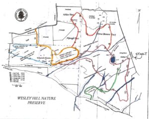
On Sunday the 8th we’ll hike the familiar Wesley Hill Nature Preserve, a Finger Lakes Land Trust property at 6060 Gulick Road in South Bristol, with an after-hike social at the newly re-opened Valley Inn on Route 20A west of Honeoye.
Meet at the Gulick Road parking area at 1:45 for a 2pm start. The full group will start out following on the Red Trail clockwise. At the Wenrich Cabin, the Tourists and Naturalists will continue on the Red Trail back to the start for a 2.8 mile loop, while the Climbers will continue to the west edge of the preserve on the Blue and Yellow trails, returning on the other half of the Red Trail for at total of about 5 miles. Trails have some ups and downs, though no sustained climbs. Wesley Hill is a Finger Lakes Land Trust property of 390 acres on the hill east of Honeoye Lake. including stands of northern hardwoods, red and white pines, hemlocks, a woodland pond, and the northern edge of Briggs Gully, set in an old forest overlooking the gully, deep in the woods. The preserve was established in 1999 by the generous donation of 90 acres by the children of three artists – John Wenrich, James Havens and Colburn Dugan – to the Finger Lakes Land Trust. Since that time, the Land Trust has expanded Wesley Hill through the purchase or donation of four additional parcels.
Directions to Trailhead:
Note: This is a change to the directions previously posted. These are directions to the Gulick Rd Parking area
From Honeoye: take route 20A east through Honeoye to East Lake Road (CR 33). Turn right onto East Lake Road. (If coming from Bristol or points east, it’s a left onto East Lake Road). Take the first left, staying on CR 33, then the first right onto Pinewood Hill which becomes Gulick Road. Travel about 3.3 miles. The parking lot is on your right.
From Springwater: Take your favorite route to Naples and proceed north on County Road 36 toward Honeoye. In 1.5 miles, make a right on Gulick Road, After about 7.9 miles (pass Camp Cutler and Cumming Nature Center), the parking lot will be on your left..
Directions to the Social from the trailhead: Turn left out of the parking area onto Gulick Road. Proceed north on Gulick, Pinewood Hill Road, and County Road 33 to East Lake Road. Make a right and then a left on Main Street (Route 20A). The Valley Inn is at 8970 Main Street, at the NE corner of the intersection of Route 20A and County Road 37, about 3/4 mile past the Honeoye traffic light.
This Sunday we will hike the western half of the Keuka Lake Outlet Trail starting at Seneca Mill and walking west to Penn Yan. The whole trail follows Keuka Lake’s outlet to Seneca Lake, starting in Penn Yan and going approximately 7 miles to Dresden, dropping 275′ along the way. The first destination will be Cherry Street (about 3.5 miles) where we’ll have cars waiting to take us back to Seneca Mill. If there is still some walking time we can continue the trail into Penn Yan. Since it’s the dead of winter snow is likely; poles and shoe gripping devices or good boots will help. This is a fairly level stretch of the Outlet trail; there are no steep sections other than a short hill at the Seneca Millpond waterfall.
This trail runs along the stream in a wooded ravine; it was formerly a canal towpath and later a railroad bed. It crosses the original Preemption Line and passes near the area of the first permanent white settlement of ‘The Universal Friend Jemima Wilkinson’, alongside waterfalls and the ruins of mills, factories and canal locks”.

The Meeting Place
Everyone will meet at the Seneca Mill Access parking area on Outlet Road at 2:00 PM. We will divide into two or three groups depending on how far people choose to hike in the two hours that they have. All hikers will walk west from Seneca Mill (that is towards Penn Yan); the climbers will walk to the Cherry Street access point in Penn Yan, while the naturalist and Tourists will hike for an hour and then turn back.
Some maps of the outlet trail will be available at the beginning of the hike: you can print your own map from The Friends of the Keuka Outlet Trail website here.
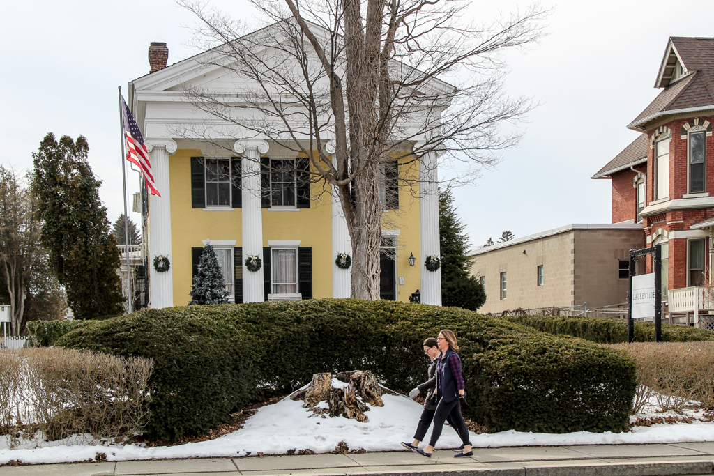
The Social
The social will be a bring-your-own-sandwich affair at the Laurentide Brewing Company at 12 Maiden Lane, Penn Yan, NY 14527. This brewing company is in a barn behind the Laurentide Inn which faces Main Street in downtown Penn Yann, across from the Post Office. The Laurentide Inn is an imposing yellow civil war era building with four huge columns holding up a portico. The brewery does not serve food but we are welcome to bring anything we want with us and just buy their beer. We can gather inside if the weather is harsh, or there is a small garden with tables that we can use if it’s warm enough. There is some parking behind the inn and plenty of street parking in front of it.
Directions:
From Springwater, Wayland and Naples. Head south from Springwater on NY-15 south to Wayland, then turn left NY-21. Follow NY-21 for 12.7 miles through N Cohocton and Naples. Turn right on NY 245N across from Bob Ruth’s. Follow NY-245 for 8.9 miles to Middlesex and take a slight right turn onto NY 364E. In the Village of Penn Yan, turn right onto Liberty St., turn left onto Clinton St (State Route 54 North) and follow it 2 miles, turn right onto Bentley Rd (which becomes Bell Road) and go for 1 mile, turn left onto Outlet Road and go for .3.5 miles,; the parking area is on right. Don’t park at the rail on the left – that is set aside for horses and buggies.
This Sunday we will explore the woods and fields overlooking Honeoye Lake on the west side, followed by a dish-to-pass social at the Affolter farm. Meet at 5422 County Road 37, about 2 miles south of Route 20A and 2 miles north of Canadice Town Hall. Park in the drive or on the road shoulder. Our hikes will take us up the ridge, through wooded trails and along gully rims. Get a new scenic vista of the whole expanse of Honeoye Lake, from a new and different perspective.
Climbers will head northwest from County Road 37 through the woods toward Curtis Road and Howcroft Road to make a loop of about 3.5 miles. Tourists and naturalists will start out on the same route, but with a slower pace on the initial uphill climb, and will complete a smaller loop of about 2.5 miles. Hiking conditions should be good, with light snow possible, but traction devices and poles are recommended in case of ice.
Bring your favorite goodies along for our social at 5422 County Road 37.
Directions:
From Springwater, take Route 15A north 2.7 miles to a right on Johnson Hill Road. In 1.1 miles, make a left on County Road 37. Continue northeast for 6.7 miles, including a turn to the left after Canadice Town Hall. #5422 will be on your left, just before you leave the town of Canadice and about a half mile after you pass Hayward Hill Road and Jersey Hill Road.
From Honeoye/Hemlock: Take Route 20A east from Hemlock or west from Honeoye to the intersection with County Road 37. Go south approximately 1.9 miles. #5422 will be on the right, just past the Entering Town of Canadice sign.
Join us on Sunday the 29th to celebrate the season in your hiking boots or on your skis as Mondoe County sponsors the 2023 Winterfest at Mendon Ponds Park. Everyone, both hikers and skiers, will meet at the Nature Center parking area at 27 Pond Road, Mendon at 1:45 for a 2PM start. Naturalists and Tourists will explore the Birdsong and Swamp Trails adjacent to the Nature Center on foot, while Climbers will hike north and east to hike the Grassland and Devil’s Bathtub trails, crossing over to the East Esker and Quaker Pond Trails to make a loop of about 5.5 miles. This is a fairly level hike, but we advise poles and traction footwear in case of ice, mud or slush.
Ski conditions are expected to be marginal, as there were only a few inches of wet snow on the ground as of Friday, and some light rain is possible Sunday. The trails will probably be busy on Sunday due to Winterfest activity, so any groomed tracks may be trodden over or melted down. Bring your ski equipment if you want to give it a try, but we suggest you bring hiking boots and equipment also as a backup plan.
Come early for more family-oriented activities elsewhere in the park between 11 and 3. See https://www.monroecounty.gov/parks-winterfest for a line-up, including food trucks at Stewart Lodge, sledding, equipment and winter sports demonstrations, Wild Wings, Zoomobile, Mercy Flight, Mounted Patrol, and more. Mendon Ponds Park map
Social afterwards at Flaherty’s Restaurant, 60 W. Main Street, Honeoye Falls.
Directions to Nature Center:
From Springwater: Head north on 15A for 21.6 miles through Hemlock and Lima. Take a right at the exit to Honeoye Falls. Stay on W Main St into the village where you will join NY 65 (1.9 mi). Continue straight onto NY 65 for 4.4 mi. (At 2 miles, you will go around a traffic circle. Stay on NY 65.) Turn right onto Pond Rd at the first park entrance. The Nature Center is just inside the entrance, on the right.
From Honeoye, take US 20A west and head north on CR 37 for 8.2 miles to W Bloomfield. Continue straight on NY 65 for about 3 miles, and make a right on Quaker Meeting House Road just before you come into Honeoye Falls. When Quaker Meeting House Road ends at Route 251 (Rush-Mendon Road), go left and then right on Route 65/Clover Street. The Pond Road entrance to the park is about 2 miles to the north, on the right. The Nature Center is just inside the entrance, on the right.
From Rochester: Exit I590 at Monroe Ave toward Pittsford. Turn right (south) onto NY 65 (Clover St). In about 6.7 you will come to the Canfield Road entrance to the park – this is not the one you want. Continue another 1.5 miles, then turn left onto Pond Rd, the second entrance into the park. The Nature Center is just inside the entrance, on the right.
Directions to Flaherty’s for Social: From Nature Center parking lot, go left to Clover Street (Route 65) and then left toward Honeoye Falls. Proceed about 5.5 miles to Honeoye Falls and through the center of the village. Flaherty’s will be on your left at #60 W. Main Street, which is Route 65.
This is a great trail to X-country ski, but it looks like we will just be just hiking this Sunday. It’s all flat and scenic and usually groomed if there is a good snow base. There is presently only an inch or two of snow, so not good skiing this time.
This week our Sunday hike will be an easy out and back, hiking with an after social at the Cottage Hotel in Mendon, New York. The Mendon trail begins where we park at the Little League ball field just off Route 251 west of the four corners of Mendon, 3865 Rush-Mendon Road. We’ll be hiking west from Mendon out about an hour with a turn-around at Chamberlain Road. It’s all flat about 4 miles out and back. Those that wish more distance, if time, can explore the trail east from Mendon toward Fishers.
This linear park has an interesting history. It’s a 15 mile plus trail extending from Ontario County through Mendon and Rush to the Genesee River with a north extension into Henrietta. It was purchased in 1995 for $1,300,000.00 and was completed and transitioned in 2004 from the old Lehigh Valley railway to a recreational trail for biking, running, cross country skiing, hiking and horseback riding.
After the hike about 4 pm, we’ll be walking from the ball park parking lot to the four corners of Mendon to the Cottage Hotel on the north east corner.
Directions: From West Bloomfield at the traffic light head north on Route 65 and in .7 miles, don’t take the curve, go straight and you will be on County Road 35 (West Bloomfield Road). Travel straight for 5.9 miles, when you reach the stop sign at Route 251, turn right. In about a mile, right across from the Ye Mendon Tavern on your left, turn right into the parking lot at the Little League Ball Field. Plenty of parking there.
Springwater Trails’Winter Hike on Sunday, February 12, 2023 on the All Western Evergreen Nursery & Christmas Tree Farm (www.allwesterntrees.com) in beautiful Springwater will begin at 2 PM, for best experience come early around 1:45 PM to sign in and meet the leader for each group.
The Western Evergreen Tree Farm in Springwater, NY
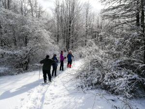
You are invited to hike on private land near the Northwestern corner of Springwater on the 245 acre All Western Evergreen Nursery & Christmas Tree Farm owned by Katherine Humphrey and daughter, Jerrianne Scheiderich. The entrance to the farm is at 6840 Liberty Pole Road (County Road 38, 1 mile from State Route 15 between Springwater and Webster’s Crossing). It is well marked and is on the high side of the road. There is parking to the left of the driveway opposite the Morton Building. Please follow the orange cones and park facing Liberty Pole Road, and sign in. Depending on the number attending, participants will be divided into Climbers (4 mile, fast pace), Tourists (3½ – 4 mile, moderate pace), and Naturalists (2-3 mile, slow pace). Designated volunteer leaders will be leading each of the hikes. Farm maps will be available so as to stay on the Farm. Please do not wander onto the neighbor’s lands. Please follow your snowshoe, ski, or hike leader (subject to the vagaries of the weather). Select a person to be the sweep (last person to keep a count of who is hiking in the group) so as not to have anyone wander off or get lost along the way.
On the hike, expect winter conditions. If there is enough snow, skis and snow shoes can be used. Dress warmly and bring water, poles, and snacks, as desired. Masks and social distancing are okay, if desired, along with all the usual precautions we’ve become accustomed to. Most of us have had the recommended vaccines and booster shots. Beware of stones, drifts, woodchuck holes, brush and stumps. We will all meet at the farm parking lot behind the house at 6840 Liberty Pole Road, Springwater, NY 14560 (GPS might say Dansville, NY 14437). Please be sure to take the Liberty Pole Road entrance at the start.
The Western Evergreen Tree Farm in Springwater, NY
Depending on weather conditions, those who want to ski will drive up to the entrance to the farm off Swartz Road following the ski leader. The Skiers will crisscross the farm from the entrance on Swartz Road, across the tree plantations, through the woods, across the tillable strips to the largest trees on the farm in the Scott Hill triangle and return. Those who wish are invited to come back to the parking lot behind the house to attend the dish-to-pass social.
It is about 1 mile across the farm in either direction; about 4 miles around the perimeter. The Tourist leader will select a route around the perimeter to see the largest trees on the farm, including Concolor fir and Red Pine. Katherine will lead the slow-paced group. Both of these groups will start out from the parking lot behind the house. The nursery beds and several exotic trees are near the residence. There is a leisurely incline from 1200 to about 2000 feet to the top of the farm and back.
The Western Evergreen Tree Farm in Springwater, NY
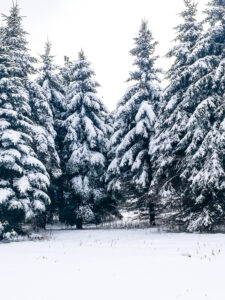
The tree farm was started in 1968, making 2023 the 55th year of planting trees. Participants may like to notice the many different species of Christmas trees planted and the animal tracks to ID. Please stay on trails to avoid trampling seedlings that may not be seen under the snow. You will see hardwoods, a red pine forest (cathedral pines planted over 75 years ago), Christmas tree plantations (some Concolor fir trees up to 35 feet tall planted in the early 1980’s), a pond, wet areas and open fields and a gorgeous view of East Springwater from the hill tops.
After the hike, a choice of hot, home-made soups will be at the farm house and people can bring their dish-to-pass before or after the hike (refrigeration, range and sockets are available). Depending on the size and comfort of the group, the garage area can be our shelter with the option of having the doors open. You are invited to bring a dish to pass, a folding chair, your preferred drink and stay for the social at the house between 4:00 and 6:30 PM.
Directions to the Farm:
From the South or North if you come down State Route15A, Springwater hamlet, at the blinking light intersection of State Route 15A, drive north on State Route 15 for a couple of miles and take the second left onto County Road 38 (Liberty Pole Road). Cross the first intersection (Carney Hollow Road, County Road 60) and in a tenth of a mile on the left high side of the Liberty Pole Road across from the 45 mile an hour sign, you will see the Tree Farm sign at 6840 Liberty Pole Road). Turn left and follow the orange cones up to the parking area and park facing forward toward Liberty Pole Road for ease in leaving at the end of the day.
From Conesus or the North, on State Route 15, go south through Webster Crossing and go straight up the Carney Hollow Road (County Road 60). At the first intersection, turn right onto County Road 38 (Liberty Pole Road) and go a tenth of a mile. Near the 45 mile an hour sign you will see the Tree Farm entrance at 6840 Liberty Pole Road. Turn left onto the high side of the road, follow the orange cones and park facing forward toward Liberty Pole Road for ease in leaving at the end of the day.
From the West from Groveland Station, take County Road 1 to Scottsburg, straight onto County Road 1A to Stage Coach Road. Go straight onto County Road 38 to 6840, where you will see the Tree Farm sign on the high side. Turn right and follow the orange cones and park facing forward toward Liberty Pole Road for ease in leaving at the end of the day
Please join us for a hike at Cumming Nature Center, in the hills above Naples. Conditions are currently poor for skiing or snowshoeing but walking should be no problem. Cumming is a branch of Rochester Museum and Science Center; if you are not a member of RMSC, there is a $5 access fee to the Center; this provides access to their rest rooms, birding platforms, snacks (free popcorn) and impressive exhibits on local wildlife.
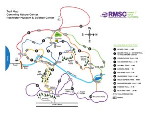
We will meet at 1:50 inside the Visitors’ Center and split into groups to make best use of the available trails and the ambitions of our hikers; trails of various lengths extend north and south from the Visitors’ Center. We will break up into two activity groups: the hikers will take one or more hiking trails. If there is enough snow then the cross country skiers and snowshoers will take the purple ski trails.
The Social: We’ll have a pot luck supper in the fireplace room. The Center closes at 5 PM.
Cumming-SummerTrailMapforPrinting_1_1
Directions
From Rochester and points North: Take 390 South to Routes 5 & 20, Proceed to Rt15A in Lima. Head South on Rt15A to Route 20A in Hemlock, Head East on 20A to East Lake Road in Honeoye. Proceed South on East Lake Road a short distance to County Road 33, (there are signs pointing the way from the junction of East Lake Road and County Road 33). Turn East on County Road 33, then Southeast on Pinewood Hill Road, which becomes becomes Gulick Road. After 5.6 miles the CNC entrance will be on the right.
From Springwater: Go North on Rt 15A to Route 20A in Hemlock, Head East on Rt 20A to East Lake Road in Honeoye. Proceed South on East Lake Road to County Road 33 (Signs point the way from the junction of East Lake Road and County Road 33). Turn East on County Road 33, then Southeast on Pinewood Hill Road. This becomes Gulick Road. After 5.6 miles the CNC entrance will be on the Right, about 1.5 miles past the Wesley Hill parking lot. OR, go to Naples and follow the directions below. They are both about 23 mile routes.
From Wayland, Naples, and points South: Follow NY 21 East from Wayland, through North Cohocton to Naples (11.4miles). Turn Left onto Clark Street (County Rd. 36), heading North (Next to Middletown Tavern). Take first Right onto Gulick Road. Follow Gulick Road for 6.6 miles. CNC will be on the Left.
NOTICE: Saturday afternoon there was about 2 inches of snow on the ground. Skiers were able to go around the park without trouble. However, the temperature is predicted to be 40 tomorrow, so it is likely that the snow will be noticeably wetter. Skiers are welcome to bring their equipment. I will provide maps and recommendations, and skiers can select their own leader. Bring hiking boots in case ski conditions have gotten worse.
NOTICE: Also on Saturday, there was ice under the snow, which made the hills a bit tricky. Traction devices (spikes or good hiking treads) and poles are recommended.
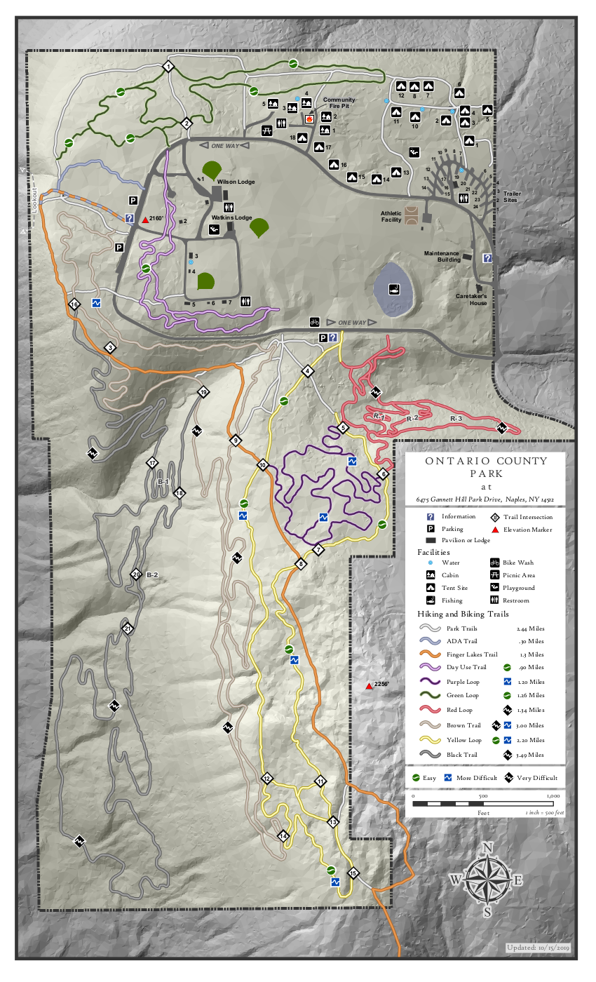
Ontario County Park provides hiking, biking, cross country skiing, fishing (no hunting), and camping or picnicking opportunities depending on the season. The park contains the highest point in Ontario County, and as a result it often has long lasting snow cover.
Please join us at the west parking along the main park road near the start of the Bristol Branch of the Finger Lakes Trail. Come early enough to get your equipment ready. We will start the hike at 2:00PM.
There are many trails within the park, although the bike trails are difficult to follow in the winter. The following planned hikes may change based on the weather and the snow cover on Sunday.
The Climbers will follow the Bristol Hills Branch of the FLT out to the overlook and then around to the south to the FLT sign-in box. At that point, we will turn around, and follow the yellow trail back to the park road and then the brown trail back to the cars. If time permits, we will explore the purple trail across the road rather then the brown trail. Poles will be helpful at slippery locations.
The Naturalists will also follow the Bristol Hills Branch out to the overlook. From there, we will leave the orange trail, turning right and follow the edge of the hill around to the north edge of the park and walk on the green trail to the campgrounds. Heading south on one of the campground roads will bring us to the park road and the field beyond. The field is open and we will head to the purple trail and back to our cars.
Social: Following our hike, join us at Brew & Brats for refreshments and conversation. Continue straight down Gannett Hill Rd to the bottom. Turn right on NY-64. Brew and Brats is on the left.
Directions: The easiest route to the park is to take NY 64 to Bristol Springs and turn west on Gannett Hill Rd. There is a sign indicating Ontario County Park. At the top of the hill turn right onto South Gannett Hill Road. The park entrance is straight ahead. Follow the park road for about .5 miles to our meeting place which is the parking area along the park road near the information kiosk at the Finger Lakes Trail trail-head.
Details From Springwater, Wayland and Naples: From Springwater, head south on NY-15. At the light in Wayland, turn left and follow NY-21 through Naples. Just past the village, bear left onto CR-12 (Bristol Springs Rd). In 1.9 miles, bear left onto Rhine St. Continue straight (In .6 mi, the name changes to Powell Rd and then in .3 mi to Gannett Hill Rd, and then in 3.2 miles it enters the park). Follow the road around the park for half a mile to our meeting place.
Details from Hemlock and Honeoye: From Hemlock, head south on NY-15A. Just outside of the hamlet, turn left on US-20A. Continue through Honeoye and turn right onto East Lake Road. In 0.6 mi, turn left onto CR 33 (Egypt Valley Rd.). In 6.9 miles, continue straight onto CR 34. In 1.6 miles, turn right onto NY-64. In another 1.9 miles, turn right onto Gannett Hill Rd. In 1.3 miles, turn right into the park. Follow the road around the park for half a mile to our meeting place.
Details from Canandaigua: Take US 20 west out of the city. Turn left onto Parrish St Ex. In 0.9 miles, turn left onto NY-21. Continue for 11.9 miles to the intersection with NY-64. Turn right onto NY-64 N. In 0.4 miles turn left onto Gannett Hill Rd. In 1.3 miles, turn right into the park. Follow the road around the park for half a mile to our meeting place.
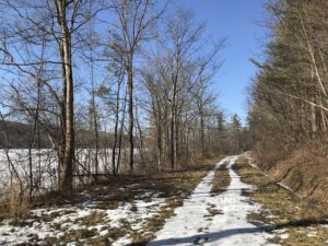 This Sunday we will enjoy a leisurely stroll along the Hemlock Lake shore on the northwest section of Rob’s Trail. The Climbers will continue up Rob’s Trail to Route 15A, and from there they’ll be ferried back to the hike start point; Naturalists and Tourists will stay on the lake shore trail and turn back to the start point whenever it suits them. The mild winter will continue this week so we’re not expecting much snow cover. If the lake level is low we can walk on the beach, but the trail offers a good flat and mostly well-drained surface. Here and there we will encounter a minor stream to cross by either wading or jumping, so waterproof footwear and poles are advised. Just in case of lingering ice or slippery mud, spikes or Yaktrax are a good idea too.
Meet at the north boat launch, at the end of the old east lake road, a sharp left after you first enter Rix Hill Road from Route 15A. This will be an out and back hike for Naturalists and Tourists; may return at any point; while Climbers will walk all the way to Route 15A for a shuttle back to the start point. At about 1.75 miles we will encounter a more substantial stream across the trail, probably too large to leap over. Any Climber wishing to proceed on Rob’s Trail past this point is advised to bring wading boots. Turning around at this point will give you a hike of 3.5 miles and a little under 2 hours.
Optional Social: Please join us at the Birdhouse Brewing Company in Honeoye – 8716 Main Street, just east of the traffic light, for craft beer and pub food.
Directions: From Springwater: proceed north on Route 15A 19 miles, then make a left on Rix Hill Road and an immediate left on Old East Lake Road, aka Boat Launch Road.
From Honeoye and points east: Take Route 20A west from the Bristol Valley and Honeoye. When 20A meets Route 15A, make a left and go about .6 miles to Rix Hill Road. Make a right and then an immediate left on the dead end road to the boat launch parking area in one mile.
From Rochester and points west: Take Route 15 south from Henrietta or Route 15A south from Honeoye Falls, or Route 390 south to the Lakeville-Livonia exit, then go south on Route 15 and then east on Route 20A through Hemlock. When Route 20A turns east toward Honeoye, go straight another .6 miles and make a right on Rix Hill Road. Then make an immediate left onto the boat launch road and go to the end, 1 mile.
To the Social: From the Boat Launch parking area, return to Rix Hill Road, make a right and then a left on Route 15A. Go .6 miles and make a right on Route 20A. In about 4.75 miles you will reach the traffic light in Honeoye. A few buildings beyond the light is Birdhouse Brewing on the left at #8716.
Looking for brochure.or mailing list so I can receive it in the mail.
Nothing opens up for mailing list.
There’s all kinds of very bizarre ads and post for viagra and other drugs above on calender page.
Please let me know if there’s a brochure available