
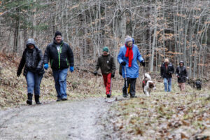
Hikes led by Springwater Trails are generally held on Sunday afternoons and appear in this calendar in green.
| Sun | Mon | Tue | Wed | Thu | Fri | Sat |
|---|---|---|---|---|---|---|
| Schribner Valley Hike 2:00 pm Schribner Valley Hike @ Hopkins House Dec 4 @ 2:00 pm – 4:00 pm Come join us for a December hike up and down the hills around Schribner Rd. We will all meet at the Hopkins House. From there, we will split into two or three groups to enjoy both views from the top … Continue reading | ||||||
| Springwater Center Hike 2:00 pm Springwater Center Hike Dec 11 @ 2:00 pm – 4:00 pm 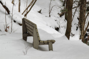 We will gather at 1:45 at the Springwater Center, 7179 Mill Street Extension, Springwater, NY. The Center is on a 220 acre property overlooking the Springwater Valley, and the Center’s staff will lead us on hikes of various lengths through … Continue reading | ||||||
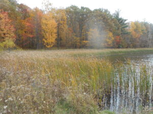
| Bath National Cemetery 2:00 pm Bath National Cemetery @ Bath Veterans Affairs Medical Center Dec 18 @ 2:00 pm – 4:00 pm  On Sunday we will walk a loop through the historic Bath National Cemetery which will have been decorated the day before as part of the Wreaths Across America campaign. The cemetery dates back to 1877 when it was started as … Continue reading | ||||||
| NO HIKE – Christmas Day 2:00 pm NO HIKE – Christmas Day Dec 25 @ 2:00 pm – 4:00 pm Merry Christmas and Happy Holidays. There will not be any hike this Sunday. We hope many of you will be enjoying your own favorite hike with your family or friends. We will see you next year (next Sunday) for our … Continue reading |
Come join us for a December hike up and down the hills around Schribner Rd. We will all meet at the Hopkins House. From there, we will split into two or three groups to enjoy both views from the top of the hills and enjoy the streams and woods at the bottom of the valley.
The Climbers will cross the road and head up through a red pine forest to the potato fields at the top on the hill. From there, we will head down to the stream and cross over in a white pine woods. After some meandering, we will return to the house for a dish to pass social.
The Tourists will wall up through an open field and then cross the road and head uphill to another potato field. From there we will head back down to the road and enjoy some walking around the house and back to the social.
Meanwhile, the Naturalists will follow the tourists up across the field, but will turn left staying on the south west side of the road. After crossing the stream at a third location, they will walk up through pine plantations to the hardwood forest. From there, they will head down to the stream again, up by a couple of old cabins and back to the house.
Following the hike, everyone is invited to join an optional social. Please bring a dish to pass, and your beverage of choice (or make a $5 contribution to the social fund). Plates and “silver”ware and coffee will be provided, thanks to Char’s care of the social funds.
Directions: It is December, so Giles and Schribner roads are closed west of our house. Even if there is no snow, you definitely do not want to try Schribner Rd from Strutt St. If you make it through, your car will not thank you.
Here are good winter directions. They will bring you in from Tabors Corners Rd and the house will be one mile up Schribner on the left. There is a mailbox by the driveway and a sign post. If you come to the intersection of Giles and Schribner, you have gone about 10 feet too far. Turn around and park on the road in the intersection If you choose to park in the driveway, pull in and turn around so you can drive out without backing up in the dark.
From Springwater: Head north on Rt 15A from the light in Springwater. Take the first right on Wheaton Hill Rd (Co Rd 16). Turn right on Wetmore Rd at the stop sign at the top of the hill. At the end of Wetmore, bear right on Tabors Corners Rd. After 3.5 miles turn right on Scribner Rd. The driveway is the 2nd driveway on the left one mile up Schribner Rd and about 10 feet before the intersection with Giles Rd. Turn around at the intersection and park on the west side of the intersection..
From Wayland: From Rt 15, head east on Rt 21 toward North Cohocton for 3 miles. Turn left on Tabors Corners Rd (Steuben Co Rd 37). After 2 miles, turn left on Schribner Rd (the second left). The driveway is the 2nd driveway on the left one mile up Schribner Rd and about 10 feet before the intersection with Giles Rd. Turn around at the intersection and park on the west side of the intersection.
From Honeoye: From Rt 20A, head south on Ontario Co Rd 37. At Canadice, continue straight ahead on Canadice Hill Rd as Co Rd 37 turns right. When Ross Rd bears to the right, stay on Canadice Hill Rd straight ahead past Harriet Hollister Spencer Park. At the Springwater Town Line Rd, continue straight ahead on Wetmore Rd. Stay on Wetmore up over the hill to the end (total distance from 20A to the end of Wetmore Rd is 10.7 miles). Bear right on Tabors Corners Rd. Turn right on at 3.5 miles on Scribner Rd. The driveway is the 2nd driveway on the left one mile up Schribner Rd and about 10 feet before the intersection with Giles Rd. Turn around at the intersection and park on the west side of the intersection.
From the East Lake Rd in Honeoye or From Naples: Rather than traveling north to reach 20A or Co Rd 37, hikers from east of Honeoye Lake may go south to Ontario Co Rd 36 and follow Co Rd 36 to Naples. Turn right on Rt 21 south. Turn right to stay on Rt 21 for 4.5 miles to N Cohocton. Turn right to stay on Rt 21 towards Wayland. After 3.8 miles turn right on Tabors Corners Rd (Steuben Co Rd 37). After 2 miles, turn left on Schribner Rd (the second left). The driveway is the 2nd driveway on the left one mile up Schribner Rd and about 10 feet before the intersection with Giles Rd. Turn around at the intersection and park on the west side of the intersection.
The Springwater Meditation Center, Springwater, NY
We will gather at 1:45 at the Springwater Center, 7179 Mill Street Extension, Springwater, NY. The Center is on a 220 acre property overlooking the Springwater Valley, and the Center’s staff will lead us on hikes of various lengths through their wooded trails. For more information on the Center and its program of retreats, see their web site at https://www.springwatercenter.org/
The Center’s land is posted, but as a precaution we advise hikers have some bright red or orange outerwear on display along with the usual winter gear – boots, poles. etc.
Social: After the hike, bring your best appetizers, entrees or desserts and your own beverage for a dish-to-pass social at the Springwater Fire Department, 8148 South Main Street (that’s Route 15, near the south end of Springwater). As an alternative you can donate $5 to our Social Fund and help yourself to the abundance. The Fire Department is the big yellow building on the left as you head south out of Springwater, across from the South End Diner. Park in the lot at the right, and come in by the pedestrian door at the far right end of the fire truck doors. Please leave plenty of parking space near the building for the firemen in the event of an emergency.
Directions to hike: Mill Street Extension is off Route 15, northwest of the hamlet Springwater. If you are coming north from Springwater, take Route 15 north from the center of town 1.25 miles, and turn right on Mil Street, just past the Harpers Ferry Road intersection. Once on Mill Street, follow the signs to the left for Springwater Center – it is down a long driveway.
If you are coming south from Rochester, take Route 390 to the Lakeville-Livonia exit, then follow Route 15 south through Livonia, Conesus, and Webster’s Crossing. About 2.25 miles past Websters Crossing, after Liberty Pole Road, you will see Mill Street on your left.
If you are coming west from Canandaigua or Honeoye by Route 5&20 or Route 20A, turn south on Route 15A in Lima or Hemlock, continue past Hemlock Lake to Springwater, and turn right on Route 15 to go up the hill to Mill Street, about 1.25 miles (top of the hill) on the right.
The Springwater Meditation Center, Springwater, NY
Directions to the Social: From Mill Street, turn left on Route 15 and head down the hill and into Springwater. At the flashing light, turn right and head south toward Wayland. The Fire Hall is at #8148, past Depot Road/Marvin Hill Road on your left and across from the South End Diner.ingwater, NY
On Sunday we will walk a loop through the historic Bath National Cemetery which will have been decorated the day before as part of the Wreaths Across America campaign. The cemetery dates back to 1877 when it was started as a burial ground for veterans who died while residing at the Grand Army of the Republic Soldiers and Sailors Home (now the VA Medical Center) in Bath.
Following the walking tour of the cemetery (about one and a half miles round trip) those who want can hike an extra loop to downtown Bath and through the Liberty Street National Historic District and Pulteney Square Village Green (about four miles round trip). Everyone should be prepared for some hills and possible slippery footing; people doing the downtown walk should bring flashlights.
Directions and Meeting Place:
Take I-390S (Genesee Expy) towards Corning then continue on I-86 (Southern Tier Expy) to the Bath – Hammondsport exit (Exit 38). Turn right onto W Washinton Street, go a short distance and cross the bridge over the Cohocton River then turn left into the first VA parking lot. Approximately 29 miles from Springwater.
Social:
The social will be at the Mountain View Inn, 34 Main Street, Atlanta, NY
More Information:
National Park Service – Bath National Cemetery: https://www.nps.gov/nr/travel/national_cemeteries/new_york/Bath_National_Cemetery.html
Wreaths Across America: https://wreathsacrossamerica.org/
National Park Service – New York State Soldiers & Sailors Home: https://www.nps.gov/places/bath-branch-bath-new-york.htm
Liberty Street National Historic District: https://en.wikipedia.org/wiki/Liberty_Street_Historic_District_(Bath,_New_York)
Other:
Those wanting to carpool can meet in Wayland behind the Fire Station – plan to be ready to leave at 1:15, to get us to the parking lot at 1:45.
There are no public bathrooms at the VA Hospital or National Cemetery.
Merry Christmas and Happy Holidays.
There will not be any hike this Sunday. We hope many of you will be enjoying your own favorite hike with your family or friends. We will see you next year (next Sunday) for our traditional 1st day hike at Canadice Lake.
The Hike:
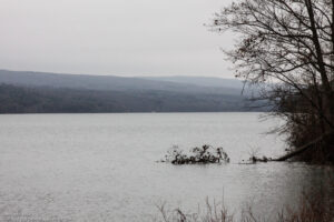
A First Day hike along Canadice Lake.
Start the New Year the way you mean to go on – come for an inspiring hike along Canadice Lake! This is an easy, 1.8-mile each way hike along the shore of the lake; the trail is level and well-maintained and the lake views are lovely. For most hikers it will be a walk along the lake for an hour or so, and then back the same way; more enthusiastic hikers can veer off on Rob’s Trail that leads over the ridge and down to Hemlock Lake – this is a moderate to hard trail with several steep uphill and downhill sections. We’ll take a roll call the day of the hike if anyone wants to walk Rob’s Trail. We’ll arrange for transport back for those who only want to walk one way. Dress appropriately for the weather, carry water and some energy food, and carry a walking pole if it helps. Leashed pets are welcome.
A First Day hike along Canadice Lake.
This is not a “routine” Sunday hike – it’s special because the hike is promoted by the NYS DEC, and is part of a larger program of First Day Hikes to encourage people to get out and experience the magnificent Sate of New York that they live in. The DEC, State Parks, and the Canal Corporation invite New Yorkers to kick off 2023 by participating in one of the many hikes being held at state parks, historic sites, wildlife areas, trails, and public lands across the Empire State. All hikers will leave with a memento of the hike and will be eligible to win an Empire Pass the allows entry to most state parks across the state.
Please note that the First Day hike this year is at 2:00pm, giving everyone a little more time to get over the night before.
The Meet-Up Location
All First Day hikers should meet at the parking area off Purcell Hill Road, Town of Canadice, Ontario County. Google Maps (leaves this website) Click here for directions.
The Social
There won’t be an organized social on this hike.
This is a change from the scheduled hike at the Hemlock lakeshore, which is rescheduled to March 5th. We’re making the calendar change to keep our distance from the Canada Goose hunting activity along the Hemlock Lake Trail, continuing through Jan. 15.
On Sunday the 8th we’ll hike the familiar Wesley Hill Nature Preserve, a Finger Lakes Land Trust property at 6060 Gulick Road in South Bristol, with an after-hike social at the newly re-opened Valley Inn on Route 20A west of Honeoye.
Meet at the Gulick Road parking area at 1:45 for a 2pm start. The full group will start out following on the Red Trail clockwise. At the Wenrich Cabin, the Tourists and Naturalists will continue on the Red Trail back to the start for a 2.8 mile loop, while the Climbers will continue to the west edge of the preserve on the Blue and Yellow trails, returning on the other half of the Red Trail for at total of about 5 miles. Trails have some ups and downs, though no sustained climbs. Wesley Hill is a Finger Lakes Land Trust property of 390 acres on the hill east of Honeoye Lake. including stands of northern hardwoods, red and white pines, hemlocks, a woodland pond, and the northern edge of Briggs Gully, set in an old forest overlooking the gully, deep in the woods. The preserve was established in 1999 by the generous donation of 90 acres by the children of three artists – John Wenrich, James Havens and Colburn Dugan – to the Finger Lakes Land Trust. Since that time, the Land Trust has expanded Wesley Hill through the purchase or donation of four additional parcels.
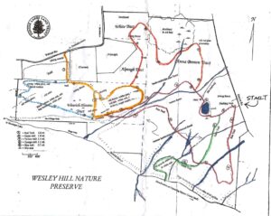
Directions to Trailhead:
Note: This is a change to the directions previously posted. These are directions to the Gulick Rd Parking area
From Honeoye: take route 20A east through Honeoye to East Lake Road (CR 33). Turn right onto East Lake Road. (If coming from Bristol or points east, it’s a left onto East Lake Road). Take the first left, staying on CR 33, then the first right onto Pinewood Hill which becomes Gulick Road. Travel about 3.3 miles. The parking lot is on your right.
From Springwater: Take your favorite route to Naples and proceed north on County Road 36 toward Honeoye. In 1.5 miles, make a right on Gulick Road, After about 7.9 miles (pass Camp Cutler and Cumming Nature Center), the parking lot will be on your left..
Directions to the Social from the trailhead: Turn left out of the parking area onto Gulick Road. Proceed north on Gulick, Pinewood Hill Road, and County Road 33 to East Lake Road. Make a right and then a left on Main Street (Route 20A). The Valley Inn is at 8970 Main Street, at the NE corner of the intersection of Route 20A and County Road 37, about 3/4 mile past the Honeoye traffic light.
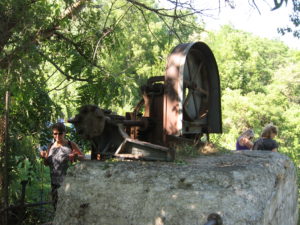
This Sunday we will hike the western half of the Keuka Lake Outlet Trail starting at Seneca Mill and walking west to Penn Yan. The whole trail follows Keuka Lake’s outlet to Seneca Lake, starting in Penn Yan and going approximately 7 miles to Dresden, dropping 275′ along the way. The first destination will be Cherry Street (about 3.5 miles) where we’ll have cars waiting to take us back to Seneca Mill. If there is still some walking time we can continue the trail into Penn Yan. Since it’s the dead of winter snow is likely; poles and shoe gripping devices or good boots will help. This is a fairly level stretch of the Outlet trail; there are no steep sections other than a short hill at the Seneca Millpond waterfall.
This trail runs along the stream in a wooded ravine; it was formerly a canal towpath and later a railroad bed. It crosses the original Preemption Line and passes near the area of the first permanent white settlement of ‘The Universal Friend Jemima Wilkinson’, alongside waterfalls and the ruins of mills, factories and canal locks”.

The Meeting Place
Everyone will meet at the Seneca Mill Access parking area on Outlet Road at 2:00 PM. We will divide into two or three groups depending on how far people choose to hike in the two hours that they have. All hikers will walk west from Seneca Mill (that is towards Penn Yan); the climbers will walk to the Cherry Street access point in Penn Yan, while the naturalist and Tourists will hike for an hour and then turn back.
Some maps of the outlet trail will be available at the beginning of the hike: you can print your own map from The Friends of the Keuka Outlet Trail website here.
The Social
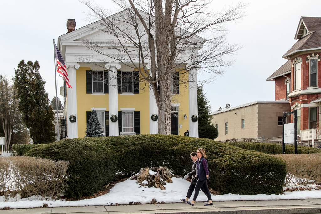
The social will be a bring-your-own-sandwich affair at the Laurentide Brewing Company at 12 Maiden Lane, Penn Yan, NY 14527. This brewing company is in a barn behind the Laurentide Inn which faces Main Street in downtown Penn Yann, across from the Post Office. The Laurentide Inn is an imposing yellow civil war era building with four huge columns holding up a portico. The brewery does not serve food but we are welcome to bring anything we want with us and just buy their beer. We can gather inside if the weather is harsh, or there is a small garden with tables that we can use if it’s warm enough. There is some parking behind the inn and plenty of street parking in front of it.
Directions:
From Springwater, Wayland and Naples. Head south from Springwater on NY-15 south to Wayland, then turn left NY-21. Follow NY-21 for 12.7 miles through N Cohocton and Naples. Turn right on NY 245N across from Bob Ruth’s. Follow NY-245 for 8.9 miles to Middlesex and take a slight right turn onto NY 364E. In the Village of Penn Yan, turn right onto Liberty St., turn left onto Clinton St (State Route 54 North) and follow it 2 miles, turn right onto Bentley Rd (which becomes Bell Road) and go for 1 mile, turn left onto Outlet Road and go for .3.5 miles,; the parking area is on right. Don’t park at the rail on the left – that is set aside for horses and buggies.
This Sunday we will explore the woods and fields overlooking Honeoye Lake on the west side, followed by a dish-to-pass social at the Affolter farm. Meet at 5422 County Road 37, about 2 miles south of Route 20A and 2 miles north of Canadice Town Hall. Park in the drive or on the road shoulder. Our hikes will take us up the ridge, through wooded trails and along gully rims. Get a new scenic vista of the whole expanse of Honeoye Lake, from a new and different perspective.
Climbers will head northwest from County Road 37 through the woods toward Curtis Road and Howcroft Road to make a loop of about 3.5 miles. Tourists and naturalists will start out on the same route, but with a slower pace on the initial uphill climb, and will complete a smaller loop of about 2.5 miles. Hiking conditions should be good, with light snow possible, but traction devices and poles are recommended in case of ice.
Bring your favorite goodies along for our social at 5422 County Road 37.
Directions:
From Springwater, take Route 15A north 2.7 miles to a right on Johnson Hill Road. In 1.1 miles, make a left on County Road 37. Continue northeast for 6.7 miles, including a turn to the left after Canadice Town Hall. #5422 will be on your left, just before you leave the town of Canadice and about a half mile after you pass Hayward Hill Road and Jersey Hill Road.
From Honeoye/Hemlock: Take Route 20A east from Hemlock or west from Honeoye to the intersection with County Road 37. Go south approximately 1.9 miles. #5422 will be on the right, just past the Entering Town of Canadice sign.
Join us on Sunday the 29th to celebrate the season in your hiking boots or on your skis as Mondoe County sponsors the 2023 Winterfest at Mendon Ponds Park. Everyone, both hikers and skiers, will meet at the Nature Center parking area at 27 Pond Road, Mendon at 1:45 for a 2PM start. Naturalists and Tourists will explore the Birdsong and Swamp Trails adjacent to the Nature Center on foot, while Climbers will hike north and east to hike the Grassland and Devil’s Bathtub trails, crossing over to the East Esker and Quaker Pond Trails to make a loop of about 5.5 miles. This is a fairly level hike, but we advise poles and traction footwear in case of ice, mud or slush.
Ski conditions are expected to be marginal, as there were only a few inches of wet snow on the ground as of Friday, and some light rain is possible Sunday. The trails will probably be busy on Sunday due to Winterfest activity, so any groomed tracks may be trodden over or melted down. Bring your ski equipment if you want to give it a try, but we suggest you bring hiking boots and equipment also as a backup plan.
Come early for more family-oriented activities elsewhere in the park between 11 and 3. See https://www.monroecounty.gov/parks-winterfest for a line-up, including food trucks at Stewart Lodge, sledding, equipment and winter sports demonstrations, Wild Wings, Zoomobile, Mercy Flight, Mounted Patrol, and more. Mendon Ponds Park map
Social afterwards at Flaherty’s Restaurant, 60 W. Main Street, Honeoye Falls.
Directions to Nature Center:
From Springwater: Head north on 15A for 21.6 miles through Hemlock and Lima. Take a right at the exit to Honeoye Falls. Stay on W Main St into the village where you will join NY 65 (1.9 mi). Continue straight onto NY 65 for 4.4 mi. (At 2 miles, you will go around a traffic circle. Stay on NY 65.) Turn right onto Pond Rd at the first park entrance. The Nature Center is just inside the entrance, on the right.
From Honeoye, take US 20A west and head north on CR 37 for 8.2 miles to W Bloomfield. Continue straight on NY 65 for about 3 miles, and make a right on Quaker Meeting House Road just before you come into Honeoye Falls. When Quaker Meeting House Road ends at Route 251 (Rush-Mendon Road), go left and then right on Route 65/Clover Street. The Pond Road entrance to the park is about 2 miles to the north, on the right. The Nature Center is just inside the entrance, on the right.
From Rochester: Exit I590 at Monroe Ave toward Pittsford. Turn right (south) onto NY 65 (Clover St). In about 6.7 you will come to the Canfield Road entrance to the park – this is not the one you want. Continue another 1.5 miles, then turn left onto Pond Rd, the second entrance into the park. The Nature Center is just inside the entrance, on the right.
Directions to Flaherty’s for Social: From Nature Center parking lot, go left to Clover Street (Route 65) and then left toward Honeoye Falls. Proceed about 5.5 miles to Honeoye Falls and through the center of the village. Flaherty’s will be on your left at #60 W. Main Street, which is Route 65.
This is a great trail to X-country ski, but it looks like we will just be just hiking this Sunday. It’s all flat and scenic and usually groomed if there is a good snow base. There is presently only an inch or two of snow, so not good skiing this time.
This week our Sunday hike will be an easy out and back, hiking with an after social at the Cottage Hotel in Mendon, New York. The Mendon trail begins where we park at the Little League ball field just off Route 251 west of the four corners of Mendon, 3865 Rush-Mendon Road. We’ll be hiking west from Mendon out about an hour with a turn-around at Chamberlain Road. It’s all flat about 4 miles out and back. Those that wish more distance, if time, can explore the trail east from Mendon toward Fishers.
This linear park has an interesting history. It’s a 15 mile plus trail extending from Ontario County through Mendon and Rush to the Genesee River with a north extension into Henrietta. It was purchased in 1995 for $1,300,000.00 and was completed and transitioned in 2004 from the old Lehigh Valley railway to a recreational trail for biking, running, cross country skiing, hiking and horseback riding.
After the hike about 4 pm, we’ll be walking from the ball park parking lot to the four corners of Mendon to the Cottage Hotel on the north east corner.
Directions: From West Bloomfield at the traffic light head north on Route 65 and in .7 miles, don’t take the curve, go straight and you will be on County Road 35 (West Bloomfield Road). Travel straight for 5.9 miles, when you reach the stop sign at Route 251, turn right. In about a mile, right across from the Ye Mendon Tavern on your left, turn right into the parking lot at the Little League Ball Field. Plenty of parking there.
Looking for brochure.or mailing list so I can receive it in the mail.
Nothing opens up for mailing list.
There’s all kinds of very bizarre ads and post for viagra and other drugs above on calender page.
Please let me know if there’s a brochure available