
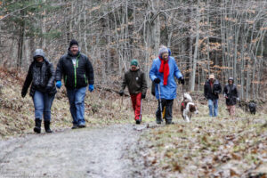
Hikes led by Springwater Trails are generally held on Sunday afternoons and appear in this calendar in green.
| Sun | Mon | Tue | Wed | Thu | Fri | Sat |
|---|---|---|---|---|---|---|
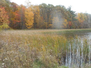
| Oatka Creek Park hike 2:00 pm Oatka Creek Park hike @ Oatka Creek Park Nov 6 @ 2:00 pm – 4:00 pm Oatka Creek Park is a hidden gem of the Monroe County Park System, a smaller property perfect for a fall hike or winter ski. Highlights include mature woods, isolated meadows, beautiful view of Oatka Creek, and the visible remains of … Continue reading | ||||||
| Ganondagan Hike 2:00 pm Ganondagan Hike @ Seneca Trail Parking Nov 13 @ 2:00 pm – 4:00 pm 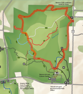 This Sunday, Springwater Trails will return to the trails of Ganondagan State Historic Site. This is a favorite location for hiking with trails contributed by the Friends of Ganondagan and by .Victor Hiking Trails. Our hikes will include the Seneca and Dryer … Continue reading | ||||||
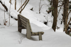
| Steege Hill Nature Preserve 2:00 pm Steege Hill Nature Preserve Sunday November 20,2022 2:00 pm Steege Hill Nature Preserve Sunday November 20,2022 @ Steege Hill Nature Preserve Nov 20 @ 2:00 pm – 4:00 pm  Description As the hunting season is upon us, our trail options are limited. Steege Hill provides a perfect refuge with its 800 acres of wooded trails that are protected and patrolled. The land for this preserve was donated to the … Continue reading | ||||||
| High Falls Riverwalk 2:00 pm High Falls Riverwalk Nov 27 @ 2:00 pm – 4:00 pm This Thanksgiving Weekend hike we will explore the historic High Falls neighborhood, starting and ending at the Genesee Brew House overlooking the Upper Falls of the Genesee. Meet at the Brew House parking lot at 25 Cataract Street, off St. … Continue reading |
Loop Hike
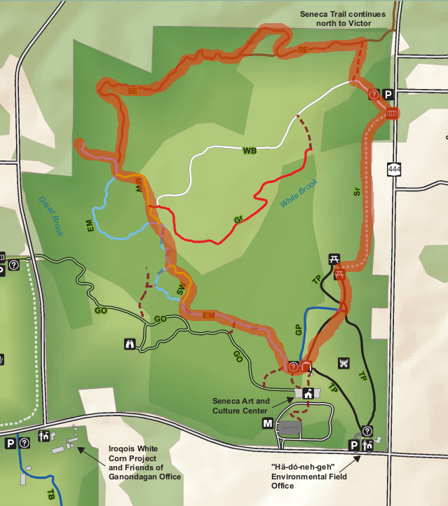
This Sunday, Springwater Trails will return to the trails of Ganondagan State Historic Site. This is a favorite location for hiking with trails contributed by the Friends of Ganondagan and by .Victor Hiking Trails. Our hikes will include the Seneca and Dryer trails, The Earth is our Mother Trail and the Trail of Peace, and will include both wooded and open grass areas, plus flat and hilly terrain. We will lead two hikes on Sunday, a loop trail that will return to the Seneca Parking Lot (about 2.5 miles), and a through hike on the Seneca and Dryer trails to the Granary Hill and the Fort Hill parking lot on Boughton Hill Rd.(about 4 miles). We will stage a couple of cars to bring us back to the Seneca Trail Parking lot.
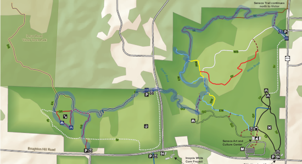
Through Hike. Click on the image for more details and to print.
Following the hike, we will gather at the Irish Mafia for a brewery social.
Directions To the Seneca Trail Parking.
From Springwater: From the light, head north on 15A. In 0.8 miles, turn right on Wheaton Hill Rd. Then turn left onto Canadice Rd (Livingston CR 42). Bear right to stay on CR 42, which becomes Ontario CR 37. Stay on CR 37 crossing NY 20A near Honeoye. At the 4-way stop, turn right onto Richmodn Mills Rd (CR 15) across Honeoye Creek. Take the first left onto CR 40 (Allens hill Rd). Follow CR 40 for 7.6 miles, crossing US 20 in Bloomfield. Turn right onto Main St, then left onto NY-444 N (Elm St). In 4.8 miles, after passing Boughton Hill Rd at a 4 way stop, the parking lot will be on the left across from Silverton Glenn Rd before you get to the village of Victor.
From Canandaigua: Take NY 332 north for about 7 miles to CR 41. Turn left on CR 41. In 3.3 miles, at the 4 way stop, turn right on NY 444. In 0.7 miles, the parking lot will be on the left across from Silverton Glenn Rd before you get to the village of Victor.
From Naples, and South Bristol: take NY 64 north for 13 miles. Turn left onto US-20, at the light (the Irish Mafia Brewery is straight ahead on the right), then right on NY 444 (in 1.2 miles). In 6 miles, the parking lot will be on the left.
From Rochester and Victor: Take I-490 East, taking Exit 29 onto NY 96 into Victor. Turn right onto Maple Ave in the center of Victor. In 0.9 miles, the parking lot will be on the right.
Directions to the Irish Mafia.
From the Seneca Trail Parking Lot: Head south on NY 444. In 6 miles, turn left on US-20. In 1.2 miles at the light, turn left onto Whalen Rd. The Brewery is on the right (the second building).
Description
As the hunting season is upon us, our trail options are limited. Steege Hill provides a perfect refuge with its 800 acres of wooded trails that are protected and patrolled. The land for this preserve was donated to the Finger Lakes Land Trust in 2001 with the stipulation that during deer hunting season it would be patrolled a minimum of 12 hours per week to protect against trespass. Our group will be contributing to this effort.
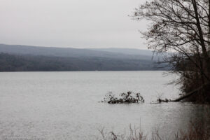
Located on a hilltop, the preserve provides a bird’s eye view of the Chemung River. The scenery here never disappoints us. The forest here is regenerating after heavy logging in the 1970’s and contains many species of hardwoods. On some of the steep slopes, original hardwoods and conifers have survived the timber cutting era. The six miles of trails are constructed mainly on former logging roads, allowing for easy navigation.
Worth mentioning are two forest residents. Timber rattlesnakes are nor common in this area but are present here. In warmer weather they enjoy sunning themselves on the sunny rocky outcroppings. By late November they are unlikely to be out and about, however caution is advised if you step off the trail. The other creature of interest, the Allegheny Mound Ant, announces its presence in the numerous home sites established along the trail and in the clearings where they seek the sunlight to warm their homes. Black bears have been sighted here as well, so keep your camera handy.
For more information about the history and geology of Steege Hill Preserve go to http://fllt.org/preserves/steege-hill-preser
Hiking Groups
Although few hunters have been encountered here over the decades, please make yourself visible by wearing blaze orange. The trails are well maintained, but conditions can vary with the weather. Please wear sturdy hiking boots and bring hiking poles.
All groups will depart from the parking area on Steege Hill Rd. There is a moderate 1/2 mile uphill walk to access the trails. Depending on the number and hiking levels of the group, the following routes may be adjusted on site.
Naturalists will enjoy a meander around the Yellow Loop with its gentle slopes and scenic pond. The distance is about 2 miles. A volunteer hike leader will be needed for this group.
Tourists will traverse the Blue, Orange, and Yellow loops, enjoying a variety of terrain and some nice views. Uphills are moderate. Distance is about 3.5 miles.
Climbers will tackle the challenging White trail, then connect with the Blue trail to return to the start for a distance of 4.5 miles. A volunteer leader will be needed for this group.
Each group leader will be provided with a map and Hunter Patrol Protocol
Directions
For those who prefer to carpool, we will meet at the Springwater Town Hall at 12:30 PM. From there, the drive is 1 hour and 8 minutes to Steege Hill.
Follow Interstate 390 South to Interstate 86 East.
Take I 86 to exit 48.
Turn onto 352 East and go 1.5 miles.
Turn right on South Corning Rd. and drive .7 miles.
After crossing the Chemung River, turn left on Steege Hill Rd.
Go .5 miles and after a steep S curve, turn left into the parking area.
Social Gathering
After the hike we will make a short drive to Tag’s Restaurant which is located at 3037State Rte 352.
For a menu go to http://tagsrestaurant.com
Here’s hoping for some dry weather next Sunday.
Come join us for a December hike up and down the hills around Schribner Rd. We will all meet at the Hopkins House. From there, we will split into two or three groups to enjoy both views from the top of the hills and enjoy the streams and woods at the bottom of the valley.
The Climbers will cross the road and head up through a red pine forest to the potato fields at the top on the hill. From there, we will head down to the stream and cross over in a white pine woods. After some meandering, we will return to the house for a dish to pass social.
The Tourists will wall up through an open field and then cross the road and head uphill to another potato field. From there we will head back down to the road and enjoy some walking around the house and back to the social.
Meanwhile, the Naturalists will follow the tourists up across the field, but will turn left staying on the south west side of the road. After crossing the stream at a third location, they will walk up through pine plantations to the hardwood forest. From there, they will head down to the stream again, up by a couple of old cabins and back to the house.
Following the hike, everyone is invited to join an optional social. Please bring a dish to pass, and your beverage of choice (or make a $5 contribution to the social fund). Plates and “silver”ware and coffee will be provided, thanks to Char’s care of the social funds.
Directions: It is December, so Giles and Schribner roads are closed west of our house. Even if there is no snow, you definitely do not want to try Schribner Rd from Strutt St. If you make it through, your car will not thank you.
Here are good winter directions. They will bring you in from Tabors Corners Rd and the house will be one mile up Schribner on the left. There is a mailbox by the driveway and a sign post. If you come to the intersection of Giles and Schribner, you have gone about 10 feet too far. Turn around and park on the road in the intersection If you choose to park in the driveway, pull in and turn around so you can drive out without backing up in the dark.
From Springwater: Head north on Rt 15A from the light in Springwater. Take the first right on Wheaton Hill Rd (Co Rd 16). Turn right on Wetmore Rd at the stop sign at the top of the hill. At the end of Wetmore, bear right on Tabors Corners Rd. After 3.5 miles turn right on Scribner Rd. The driveway is the 2nd driveway on the left one mile up Schribner Rd and about 10 feet before the intersection with Giles Rd. Turn around at the intersection and park on the west side of the intersection..
From Wayland: From Rt 15, head east on Rt 21 toward North Cohocton for 3 miles. Turn left on Tabors Corners Rd (Steuben Co Rd 37). After 2 miles, turn left on Schribner Rd (the second left). The driveway is the 2nd driveway on the left one mile up Schribner Rd and about 10 feet before the intersection with Giles Rd. Turn around at the intersection and park on the west side of the intersection.
From Honeoye: From Rt 20A, head south on Ontario Co Rd 37. At Canadice, continue straight ahead on Canadice Hill Rd as Co Rd 37 turns right. When Ross Rd bears to the right, stay on Canadice Hill Rd straight ahead past Harriet Hollister Spencer Park. At the Springwater Town Line Rd, continue straight ahead on Wetmore Rd. Stay on Wetmore up over the hill to the end (total distance from 20A to the end of Wetmore Rd is 10.7 miles). Bear right on Tabors Corners Rd. Turn right on at 3.5 miles on Scribner Rd. The driveway is the 2nd driveway on the left one mile up Schribner Rd and about 10 feet before the intersection with Giles Rd. Turn around at the intersection and park on the west side of the intersection.
From the East Lake Rd in Honeoye or From Naples: Rather than traveling north to reach 20A or Co Rd 37, hikers from east of Honeoye Lake may go south to Ontario Co Rd 36 and follow Co Rd 36 to Naples. Turn right on Rt 21 south. Turn right to stay on Rt 21 for 4.5 miles to N Cohocton. Turn right to stay on Rt 21 towards Wayland. After 3.8 miles turn right on Tabors Corners Rd (Steuben Co Rd 37). After 2 miles, turn left on Schribner Rd (the second left). The driveway is the 2nd driveway on the left one mile up Schribner Rd and about 10 feet before the intersection with Giles Rd. Turn around at the intersection and park on the west side of the intersection.
The Springwater Meditation Center, Springwater, NY
We will gather at 1:45 at the Springwater Center, 7179 Mill Street Extension, Springwater, NY. The Center is on a 220 acre property overlooking the Springwater Valley, and the Center’s staff will lead us on hikes of various lengths through their wooded trails. For more information on the Center and its program of retreats, see their web site at https://www.springwatercenter.org/
The Center’s land is posted, but as a precaution we advise hikers have some bright red or orange outerwear on display along with the usual winter gear – boots, poles. etc.
Social: After the hike, bring your best appetizers, entrees or desserts and your own beverage for a dish-to-pass social at the Springwater Fire Department, 8148 South Main Street (that’s Route 15, near the south end of Springwater). As an alternative you can donate $5 to our Social Fund and help yourself to the abundance. The Fire Department is the big yellow building on the left as you head south out of Springwater, across from the South End Diner. Park in the lot at the right, and come in by the pedestrian door at the far right end of the fire truck doors. Please leave plenty of parking space near the building for the firemen in the event of an emergency.
Directions to hike: Mill Street Extension is off Route 15, northwest of the hamlet Springwater. If you are coming north from Springwater, take Route 15 north from the center of town 1.25 miles, and turn right on Mil Street, just past the Harpers Ferry Road intersection. Once on Mill Street, follow the signs to the left for Springwater Center – it is down a long driveway.
If you are coming south from Rochester, take Route 390 to the Lakeville-Livonia exit, then follow Route 15 south through Livonia, Conesus, and Webster’s Crossing. About 2.25 miles past Websters Crossing, after Liberty Pole Road, you will see Mill Street on your left.
If you are coming west from Canandaigua or Honeoye by Route 5&20 or Route 20A, turn south on Route 15A in Lima or Hemlock, continue past Hemlock Lake to Springwater, and turn right on Route 15 to go up the hill to Mill Street, about 1.25 miles (top of the hill) on the right.
The Springwater Meditation Center, Springwater, NY
Directions to the Social: From Mill Street, turn left on Route 15 and head down the hill and into Springwater. At the flashing light, turn right and head south toward Wayland. The Fire Hall is at #8148, past Depot Road/Marvin Hill Road on your left and across from the South End Diner.ingwater, NY
On Sunday we will walk a loop through the historic Bath National Cemetery which will have been decorated the day before as part of the Wreaths Across America campaign. The cemetery dates back to 1877 when it was started as a burial ground for veterans who died while residing at the Grand Army of the Republic Soldiers and Sailors Home (now the VA Medical Center) in Bath. 
Following the walking tour of the cemetery (about one and a half miles round trip) those who want can hike an extra loop to downtown Bath and through the Liberty Street National Historic District and Pulteney Square Village Green (about four miles round trip). Everyone should be prepared for some hills and possible slippery footing; people doing the downtown walk should bring flashlights.
Directions and Meeting Place:
Take I-390S (Genesee Expy) towards Corning then continue on I-86 (Southern Tier Expy) to the Bath – Hammondsport exit (Exit 38). Turn right onto W Washinton Street, go a short distance and cross the bridge over the Cohocton River then turn left into the first VA parking lot. Approximately 29 miles from Springwater.
Social:
The social will be at the Mountain View Inn, 34 Main Street, Atlanta, NY
More Information:
National Park Service – Bath National Cemetery: https://www.nps.gov/nr/travel/national_cemeteries/new_york/Bath_National_Cemetery.html
Wreaths Across America: https://wreathsacrossamerica.org/
National Park Service – New York State Soldiers & Sailors Home: https://www.nps.gov/places/bath-branch-bath-new-york.htm
Liberty Street National Historic District: https://en.wikipedia.org/wiki/Liberty_Street_Historic_District_(Bath,_New_York)
Other:
Those wanting to carpool can meet in Wayland behind the Fire Station – plan to be ready to leave at 1:15, to get us to the parking lot at 1:45.
There are no public bathrooms at the VA Hospital or National Cemetery.
Merry Christmas and Happy Holidays.
There will not be any hike this Sunday. We hope many of you will be enjoying your own favorite hike with your family or friends. We will see you next year (next Sunday) for our traditional 1st day hike at Canadice Lake.
The Hike:
A First Day hike along Canadice Lake.
Start the New Year the way you mean to go on – come for an inspiring hike along Canadice Lake! This is an easy, 1.8-mile each way hike along the shore of the lake; the trail is level and well-maintained and the lake views are lovely. For most hikers it will be a walk along the lake for an hour or so, and then back the same way; more enthusiastic hikers can veer off on Rob’s Trail that leads over the ridge and down to Hemlock Lake – this is a moderate to hard trail with several steep uphill and downhill sections. We’ll take a roll call the day of the hike if anyone wants to walk Rob’s Trail. We’ll arrange for transport back for those who only want to walk one way. Dress appropriately for the weather, carry water and some energy food, and carry a walking pole if it helps. Leashed pets are welcome.
A First Day hike along Canadice Lake.
This is not a “routine” Sunday hike – it’s special because the hike is promoted by the NYS DEC, and is part of a larger program of First Day Hikes to encourage people to get out and experience the magnificent Sate of New York that they live in. The DEC, State Parks, and the Canal Corporation invite New Yorkers to kick off 2023 by participating in one of the many hikes being held at state parks, historic sites, wildlife areas, trails, and public lands across the Empire State. All hikers will leave with a memento of the hike and will be eligible to win an Empire Pass the allows entry to most state parks across the state.
Please note that the First Day hike this year is at 2:00pm, giving everyone a little more time to get over the night before.
The Meet-Up Location
All First Day hikers should meet at the parking area off Purcell Hill Road, Town of Canadice, Ontario County. Google Maps (leaves this website) Click here for directions.
The Social
There won’t be an organized social on this hike.
This is a change from the scheduled hike at the Hemlock lakeshore, which is rescheduled to March 5th. We’re making the calendar change to keep our distance from the Canada Goose hunting activity along the Hemlock Lake Trail, continuing through Jan. 15.
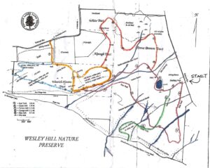
On Sunday the 8th we’ll hike the familiar Wesley Hill Nature Preserve, a Finger Lakes Land Trust property at 6060 Gulick Road in South Bristol, with an after-hike social at the newly re-opened Valley Inn on Route 20A west of Honeoye.
Meet at the Gulick Road parking area at 1:45 for a 2pm start. The full group will start out following on the Red Trail clockwise. At the Wenrich Cabin, the Tourists and Naturalists will continue on the Red Trail back to the start for a 2.8 mile loop, while the Climbers will continue to the west edge of the preserve on the Blue and Yellow trails, returning on the other half of the Red Trail for at total of about 5 miles. Trails have some ups and downs, though no sustained climbs. Wesley Hill is a Finger Lakes Land Trust property of 390 acres on the hill east of Honeoye Lake. including stands of northern hardwoods, red and white pines, hemlocks, a woodland pond, and the northern edge of Briggs Gully, set in an old forest overlooking the gully, deep in the woods. The preserve was established in 1999 by the generous donation of 90 acres by the children of three artists – John Wenrich, James Havens and Colburn Dugan – to the Finger Lakes Land Trust. Since that time, the Land Trust has expanded Wesley Hill through the purchase or donation of four additional parcels.
Directions to Trailhead:
Note: This is a change to the directions previously posted. These are directions to the Gulick Rd Parking area
From Honeoye: take route 20A east through Honeoye to East Lake Road (CR 33). Turn right onto East Lake Road. (If coming from Bristol or points east, it’s a left onto East Lake Road). Take the first left, staying on CR 33, then the first right onto Pinewood Hill which becomes Gulick Road. Travel about 3.3 miles. The parking lot is on your right.
From Springwater: Take your favorite route to Naples and proceed north on County Road 36 toward Honeoye. In 1.5 miles, make a right on Gulick Road, After about 7.9 miles (pass Camp Cutler and Cumming Nature Center), the parking lot will be on your left..
Directions to the Social from the trailhead: Turn left out of the parking area onto Gulick Road. Proceed north on Gulick, Pinewood Hill Road, and County Road 33 to East Lake Road. Make a right and then a left on Main Street (Route 20A). The Valley Inn is at 8970 Main Street, at the NE corner of the intersection of Route 20A and County Road 37, about 3/4 mile past the Honeoye traffic light.
Looking for brochure.or mailing list so I can receive it in the mail.
Nothing opens up for mailing list.
There’s all kinds of very bizarre ads and post for viagra and other drugs above on calender page.
Please let me know if there’s a brochure available