
Hikes led by Springwater Trails are generally held on Sunday afternoons and appear in this calendar in green.
| Sun | Mon | Tue | Wed | Thu | Fri | Sat |
|---|---|---|---|---|---|---|
| Lehigh Valley Trail Linear Park Monroe County Parks Mendon, New York 2:00 pm Lehigh Valley Trail Linear Park Monroe County Parks Mendon, New York @ Trailhead parking at the Little League Ball Park just off Route 251 in Mendon, New York Feb 6 @ 2:00 pm – 4:00 pm This week our Sunday hike will be an easy out and back, hike or x-country ski depending on the weather with an after social at the Cottage Hotel in Mendon, New York. The Mendon trail begins where we park at … Continue reading | ||||||
| Genesee Valley Greenway in Scottsville 2:00 pm Genesee Valley Greenway in Scottsville Feb 13 @ 2:00 pm – 4:00 pm 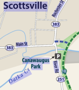 On Sunday, February 13th we will hike/cross country ski/snowshoe a section of the Genesee Valley Greenway Trail starting in Scottsville. The trail is flat, tree lined, and follows along the Genesee river. Snowmobiles have packed the snow down on the … Continue reading | ||||||
| Winter Hike 2:00 pm Winter Hike @ All Western Evergreen Farm Feb 20 @ 2:00 pm – 4:00 pm 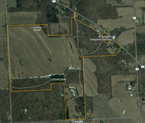 You are invited to hike on private land near the Northwestern corner of Springwater on the 248 acre All Western Evergreen Nursery & Christmas Tree Farm owned by Katherine Humphrey and daughter, Jerrianne Scheiderich. The entrance to the farm is at 6840 … Continue reading | ||||||
| White Brook and Crescent Trail 2:00 pm White Brook and Crescent Trail @ Lyndon Rd Trailhead Feb 27 @ 2:00 pm – 4:00 pm 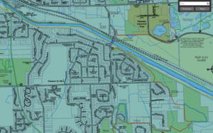 ————————- Change of Plans – We will meet at the trail head on the south side of the canal. See below ——— The Crescent Trail in Perinton, NY, is approximately 35 miles of footpaths starting in Bushnell’s Basin on the … Continue reading |
————————- Change of Plans – We will meet at the trail head on the south side of the canal. See below ———
The Crescent Trail in Perinton, NY, is approximately 35 miles of footpaths starting in Bushnell’s Basin on the Erie Canal, and currently ending at Northside School in northern Perinton. Planned, developed and maintained by the Crescent Trail Association, this trail is built on state, town and private lands and connects with the Canalway trail and the Trolley trail, two multiuse trails in the town.
NOTE: Our original plans for this hike were at Indian Hill. However, ice on the trail and in the parking lot, made this hike best postponed until the trillium are out this spring. This Sunday hike has been moved to a flatter location that should not be as dangerous with ice. However, traction devices or snowshoes are highly recommended – bring extras if you would like to loan them to poorly prepared hikers.
NOTE 2: Snow is expected. Check the weather and dress accordingly. Remember to drive safely.
This Sunday we will hike a portion of the Crescent Trail along the Erie Canal and the White Brook Nature Area. We will meet at the trail head parking lot south of the canal off of Lyndon Rd. (The baseball parking lot was not plowed on Saturday, so we will avoid that.)
Three hike options will be available. All hikes will follow the road across the railroad tracks and the canal to the south side of the canal and the trail head on the east side of the road (about 2000 ft). The climbers will follow the orange trail to the northern part of the White Brook Nature Area, where we will leave the orange to follow the blue trail around the field and back to the orange and home, for a total of about 4 miles.
The tourists will follow start on the orange trail but will take the second turn left on the yellow trail, crossing White Brook and heading east along the canal. The trail ends at the Perinton town line, and returns along a blue trail at the canal’s edge. As the tourists approach the Lyndon bridge, they will have the option to continue along the canal toward Fairport, or to turn south back to the trail head, then across the canal to the ramp to the Canalway on the north side of the canal. The tourist hike leader should check a watch and plan a turn-around time on the canal path to return to the cars at 4.
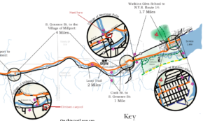
Canal and White Brook trail map. Click for full Crescent Trail map
The Naturalists will take the first left from the orange trail onto the yellow trail to head west the canal on a trail between the White Brook and the Canal. In about 1.5 miles, they will leave the canal, on a short climb to the trolley path, cross the canal on the footbridge and walk back to the cars on the Canalway on the north side of the canal for a total of about 3 miles.
If the weather permits, skiers will follow the climbers trail into White Brook.
Traction devices (spikes or spring coils) or snowshoes are highly recommended for all hikers. A nice layer of snow provides reasonable traction, but underneath is ice, making for slippery conditions at times.
Following the hike, Noonan’s on Rt 31 will be open for a brew and refreshments.
Directions to the Trail Head.
From Turk Hill Rd and Rt 31 in Perinton: Head north on Turk Hill Rd. Turn right onto Ayrault Rd at the next light. In 1.5 miles, at the bottom of a steep hill, turn left onto Lyndon Rd. Just before the bridge over the canal, the parking area is on the right.
From Springwater: From the flashing light, head north on Rt 15A for 2.7. miles. Bear right onto Old Bald Hill Rd S, then an immediate right onto Johnson Hill Rd. Continue on Johnson Hill Rd to the end. Turn left onto Co Rd 37. Stay on CR 37 for 11 miles (there is a left turn in Canadice to stay on CR 37) past Honeoye. Turn right onto Richmond Mills Rd and then left at the 1st cross street onto CR 40. After crossing 5 & 20, turn right onto Main St in Bloomfield. At the light turn left onto NY 444 for 5.7 miles into Victor. Turn right onto Main St (NY 96) then left on Church St. Continue north for 6 miles. past Lollypop Farm. Turn right onto NY 31, then left onto Aldrich Rd. The road turns left to become Ayrault Rd. In half a mile, turn right onto Lyndon Rd. Just before the bridge over the canal, the parking area is on the right.
From Rochester: Take I-490 E to exit 26, NY-31. Turn east on NY-31. In 0.4 miles, at the light, turn left onto Ayrault Rd. You will pass the Middle School and the High School before going down a steep hill. At the bottom (3.8 mi from Rt 31), turn left onto Lyndon Rd. Just before the bridge over the canal, the parking area is on the right.
From Naples: Take NY 21 north from Naples to South Bristol. Continue straight onto NY 64. In 13 miles at the light, turn left onto 5 & 20 west. In 6.8 miles turn right onto NY 444N to Victor. Turn right onto Main St (NY 96) then left on Church St. Continue north for 6 miles. past Lollypop Farm. Turn right onto NY 31, then left onto Aldrich Rd. The road turns left to become Ayrault Rd. In half a mile, turn right onto Lyndon Rd. Just before the bridge over the canal, the parking area is on the right.
From Canandaigua: Take NY 332 north to a left onto NY 96 N. At the traffic circle near Victor, take the first exit onto Lynaugh Rd. In 1 mile turn right onto Victor Egypt Rd. Continue north for 5 miles. past Lollypop Farm. Turn right onto NY 31, then left onto Aldrich Rd. The road turns left to become Ayrault Rd. In half a mile, turn right onto Lyndon Rd. Just before the bridge over the canal, the parking area is on the right.
From Geneseo: Take I-390 north to Rochester. Take exit 15 onto I-590 N. Take exit 5 onto I-490 E toward Victor and follow the directions from Rochester.
Directions to Noonan’s: Head south on Lyndon Rd. At the stop sign, turn right on Ayrault Rd. Take the first left at the top of the hill onto Mason Rd. At the light, turn right onto NY 31 W. Noonan’s is a white building on the right. Park behind the restaurant.
 This Sunday we will enjoy a leisurely stroll along the Hemlock Lake shore on the northwest section of Rob’s Trail. Temperatures are expected to rise this week, so we’re not expecting much snow cover. The lake level is high, probably still iced over, and walking on the beach is not an option, but the trail offers a good flat and mostly well-drained surface. Here and there we will encounter a minor stream to cross by either wading or jumping, so waterproof footwear and poles are advised. Just in case of lingering ice, spikes or yaktrax are a good idea too.
Meet at the north boat launch, at the end of the old east lake road, a sharp left after you first enter Rix Hill Road from Route 15A. This will be an out and back hike; Naturalists and Tourists may return at any point. At about 1.75 miles we will encounter a more substantial stream across the trail, probably too large to leap over. Any Climber wishing to proceed on Rob’s Trail past this point is advised to bring wading boots. Turning around at this point will give you a hike of 3.5 miles and a little under 2 hours.
Optional Social: Please join us at the Birdhouse Brewing Company in Honeoye – 8716 Main Street, just east of the traffic light, for craft beer and pub food.
Directions: From Springwater: proceed north on Route 15A 19 miles, then make a left on Rix Hill Road and an immediate left on Old East Lake Road, a.k.a Boat Launch Road.
From Honeoye and points east: Take Route 20A west from the Bristol Valley and Honeoye. When 20A meets Route 15A, make a left and go about .6 miles to Rix Hill Road. Make a right and then an immediate left on the dead end road to the boat launch parking area in one mile.
From Rochester and points west: Take Route 15 south from Henrietta or Route 15A south from Honeoye Falls, or Route 390 south to the Lakeville-Livonia exit, then go south on Route 15 and then east on Route 20A through Hemlock. When Route 20A turns east toward Honeoye, go straight another .6 miles and make a right on Rix Hill Road. Then make an immediate left onto the boat launch road and go to the end, 1 mile.
To the Social: From the Boat Launch parking area, return to Rix Hill Road, make a right and then a left on Route 15A. Go .6 miles and make a right on Route 20A. In about 4.75 miles you will reach the traffic light in Honeoye. A few buildings beyond the light is Birdhouse Brewing on the left at #8716.
This Sunday we will hike the western half of the Keuka Lake Outlet Trail starting at Seneca Mill and walking west to Penn Yan. The whole trail follows Keuka Lake’s outlet to Seneca Lake, starting in Penn Yan and going approximately 7 miles to Dresden, dropping 275′ along the way. The first destination will be Cherry Street (about 3.5 miles) where we’ll have cars waiting to take us back to Seneca Mill. If there is still some walking time we can continue the trail into Penn Yan. Since it’s getting on for spring then mud is likely so poles and shoe gripping devices or good boots will help.
This trail runs along the stream in a wooded ravine; it was formerly a canal towpath and later a railroad bed. It crosses the original Preemption Line and passes near the area of the first permanent white settlement of ‘The Universal Friend Jemima Wilkinson’, alongside waterfalls and the ruins of mills, factories and canal locks”.

The Meeting Place
Everyone will meet at the Seneca Mill Access parking area on Outlet Road at 2:00 PM. We will divide into two or three groups depending on how far people choose to hike in the two hours that they have. All hikers will walk west from Seneca Mill (that is towards Penn Yan); the climbers will walk to the Cherry Street access point in Penn Yan, while the naturalist and Tourists will hike for an hour and then turn back.
With the spring thaw under way the outlet should be flowing in spate, so it will be worth walking slowly and taking lots of photographs.
Some maps of the outlet trail will be available at the beginning of the hike: you can print your own map from The Friends of the Keuka Outlet Trail website here.
The Social
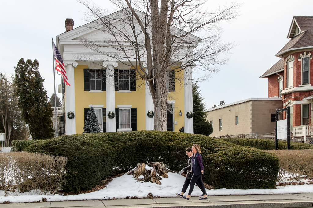
The social will be a share-a-dish affair at the Laurentide Brewing Company at 12 Maiden Lane, Penn Yan, NY 14527. This brewing company is in a barn behind the Laurentide Inn which faces Main Street in downtown Penn Yann, across from the Post Office. The Laurentide Inn is an imposing yellow civil war era building with four huge columns holding up a portico. The brewery does not serve food but we are welcome to bring anything we want with us and just buy their beer. We can gather inside if the weather is harsh, or there is a small garden with tables that we can use if it’s warm enough. There is some parking behind the inn and plenty of street parking in front of it.
Directions:
From Springwater, Wayland and Naples. Head south from Springwater on NY-15 south to Wayland, then turn left NY-21. Follow NY-21 for 12.7 miles through N Cohocton and Naples. Turn right on NY 245N across from Bob Ruth’s. Follow NY-245 for 8.9 miles to Middlesex and take a slight right turn onto NY 364E. In the Village of Penn Yan, turn right onto Liberty St., turn left onto Clinton St (State Route 54 North) and follow it 2 miles, turn right onto Bentley Rd (which becomes Bell Road) and go for 1 mile, turn left onto Outlet Road and go for .3.5 miles,; the parking area is on right. Don’t park at the rail on the left – that is set aside for horses and buggies.
Weather Update, Sunday March 20: Looks like there will likely be steady rain this afternoon. We’ll be hiking if any hardy souls show up, but please bring rain gear, traction footwear, poles and gaiters, as it’s likely to be muddy and maybe slippery. Hike may be shortened if that’s the group consensus.
Our hike this Sunday will be at the Ganondagan State Historic Site, 7000 County Road 41 (Boughton Hill Road) in Victor. Ganondagan is the site of a large 17th century Seneca town, and offers hiking trails with interpretive markers illustrating the history and traditions of the Seneca people. The trails will take us through wooded rolling hills and meadows just south of the Village of Victor. Highlights will include the Granary Trail, where the Seneca protected and distributed their corn supplies on a palisaded mesa, and the Earth is Our Mother Trail, where interpretive markers describe local plants and their particular roles in Seneca life. See https://ganondagan.org/Visit/Hiking-Trails for more on Ganondagan and its interpretive trails.
We will meet at 1:45 at the Seneca Art and Culture Center parking lot, about .2 miles west of the intersection of Route 444 and Boughton Hill Road. All hikers will proceed past the Longhouse and around the Great Meadow to the Seneca Trail and then follow the Earth is Our Mother Trail along Great Brook. After about 2 miles, we will divide into two groups, with the Tourists and Naturalists returning to the Longhouse and parking area via the Great Oak Trail for a total hike of about 2.5 miles. The Climbers will cross School Street and proceed up the hill by the Eagle Trail to the Granary, where we can stop for a long view to the south over the Bristol Hills and Bare Hill, then return to School Street and the starting point via the rest of the Earth is Our Mother Trail. Total hike for the Climbers will be about 4.5 miles. Trails are well maintained and gently rolling hills, with switchbacks up steeper areas. In case of mud, poles and traction devices are advised.
Social – Will be at Cheap Charlie’s Restaurant, 8 Elm Street, Bloomfield (on Route 444, left side, as you enter Holcomb)
Directions: From Springwater/Honeoye area: Go north to Honeoye and then east on 20A to Route 64. Go north on 64 for 3.7 miles to the 5 and 20 intersection. Go west on 5 and 20 for 1.25 miles and make a right on Route 444 (Maple Ave.). Proceed 5.3 miles to Boughton Hill Road (County Rd. 41). Turn left at Boughton Hill Road (flashing light), proceed .2 mile down the hill. The Seneca Art and Culture Center is the white and glass contemporary building on your right, with a large parking lot in front.
From points east: Take 5 and 20 west toward Bloomfield. Go right at the Route 444 intersection, and proceed 5.3 miles north to Boughton Hill Road (County Rd. 41) (flashing light). Turn left at Boughton Hill Road, proceed .2 mile down the hill. The Seneca Art and Culture Center (a.k.a. Interpretive Center) is the white and glass contemporary building on your right, with a large parking lot in front.
From Thruway: Take Exit 45, and follow Route 96 east to the Village of Victor. In the village center, turn right on Route 444 (Maple Avenue). Go 1.5 miles to the top of Boughton Hill (flashing light). Turn right on Boughton Hill Road. Proceed .2 mile down the hill. The Seneca Art and Culture Center (a.k.a. Interpretive Center) is the white and glass contemporary building on your right, with a large parking lot in front.
To the Social: From the site, go east on Boughton Hill Road. Make a right at the flashing light and follow Route 444 to Holcomb, about 4 miles. Cheap Charlie’s is on the left at 8 Elm Street.
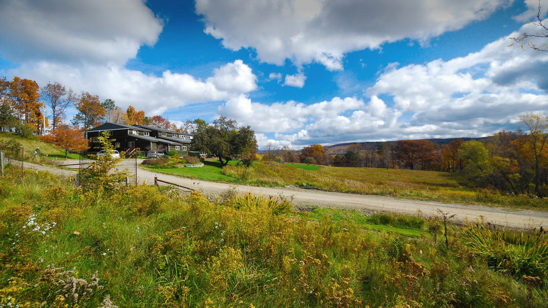
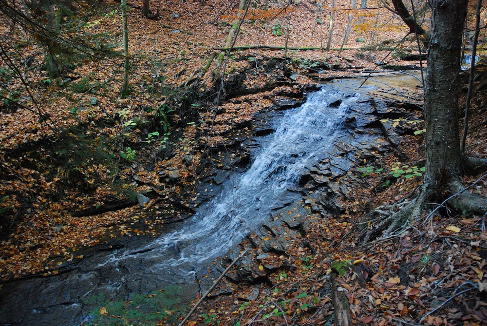
The Springwater Center, founded in 1981 by Toni Packer, is located in the northwest portion of Springwater. The property contains open fields, forests and waterfalls and provides many opportunities to enjoy the beauty of Springwater. The Center offers silent meditation retreats and year-round guest visits, currently to fully vaccinated guests. Springwater Trails has been regular guests at the center, always enjoying the center’s hikes.
There will be up to three hikes for the group to select from, each lead by a leader well versed in both the history and the landscape of the Center’s property. We can expect up-close views of Mill Creek waterfalls, and long views of Springwater Valley.
 All hikers will meet at Wayne Coger and Susan McCallum’s house. Their house is adjacent to the east side of the Center property. Hikes will start at 2:00. Following the hike, you are invited to a dish to pass social at Wayne and Susan‘s house. Please bring a dish to share or your own snack and your own beverage. Oven and microwave will be available to keep food warm or reheat, if needed.
From Springwater: Heading south on Rte. 15A turn right onto Kellogg Road (1st right on the north edge of the village). Continue on Kellogg about ¾ mile to where Marrowback Road tees into Kellogg. Turn right onto Marrowback, continue about ¾ mile to the 1st driveway on the left. Turn left, continue a short distance to the top of the T and turn left again. One of us will meet you and direct you to parking areas. Similarly, if heading into Springwater on 15A from south of the village, turn left onto Kellogg at the north edge of town and then follow the directions above.
If coming south on 15, turn left onto Kellog (it loops between 15 & 15A and then left onto Marrowback. Then continue as written above.
Please click for detailed directions from Rochester, Livonia, and Naples.
This Sunday we will explore the woods and fields overlooking Honeoye Lake on the west side, followed by a dish-to-pass social at the Affolter farm. Meet at 5422 County Road 37, about 2 miles south of Route 20A and 2 miles north of Canadice Town Hall. Park in the drive or on the road shoulder. Our hikes will take us up the ridge, through wooded trails and along gully rims. Get a scenic vista of the whole expanse of Honeoye Lake, from a new and different perspective.
There will be a longer hike for the Climbers of 3.5 to 4 miles, and a shorter hike for the Tourists-Naturalists of 2 to 3 miles. Hiking conditions should be good, but layers are advised, and traction devices and poles are recommended in case of mud.
Bring your favorite goodies along for an indoor dish-to-pass social at the hike starting point.
Directions: From Springwater, take Route 15A north 2.7 miles to a right on Johnson Hill Road. In 1.1 miles, make a left on County Road 37. Continue northeast for 6.7 miles, including a turn to the left after Canadice Town Hall. #5422 will be on your left, just before you leave the town of Canadice and about a half mile after you pass Hayward Hill Road and Jersey Hill Road.
From Honeoye/Hemlock: Take Route 20A east from Hemlock or west from Honeoye to the intersection with County Road 37. Go south approximately 1.9 miles. #5422 will be on the right, just past the Entering Town of Canadice sign.
Click image for more detail.
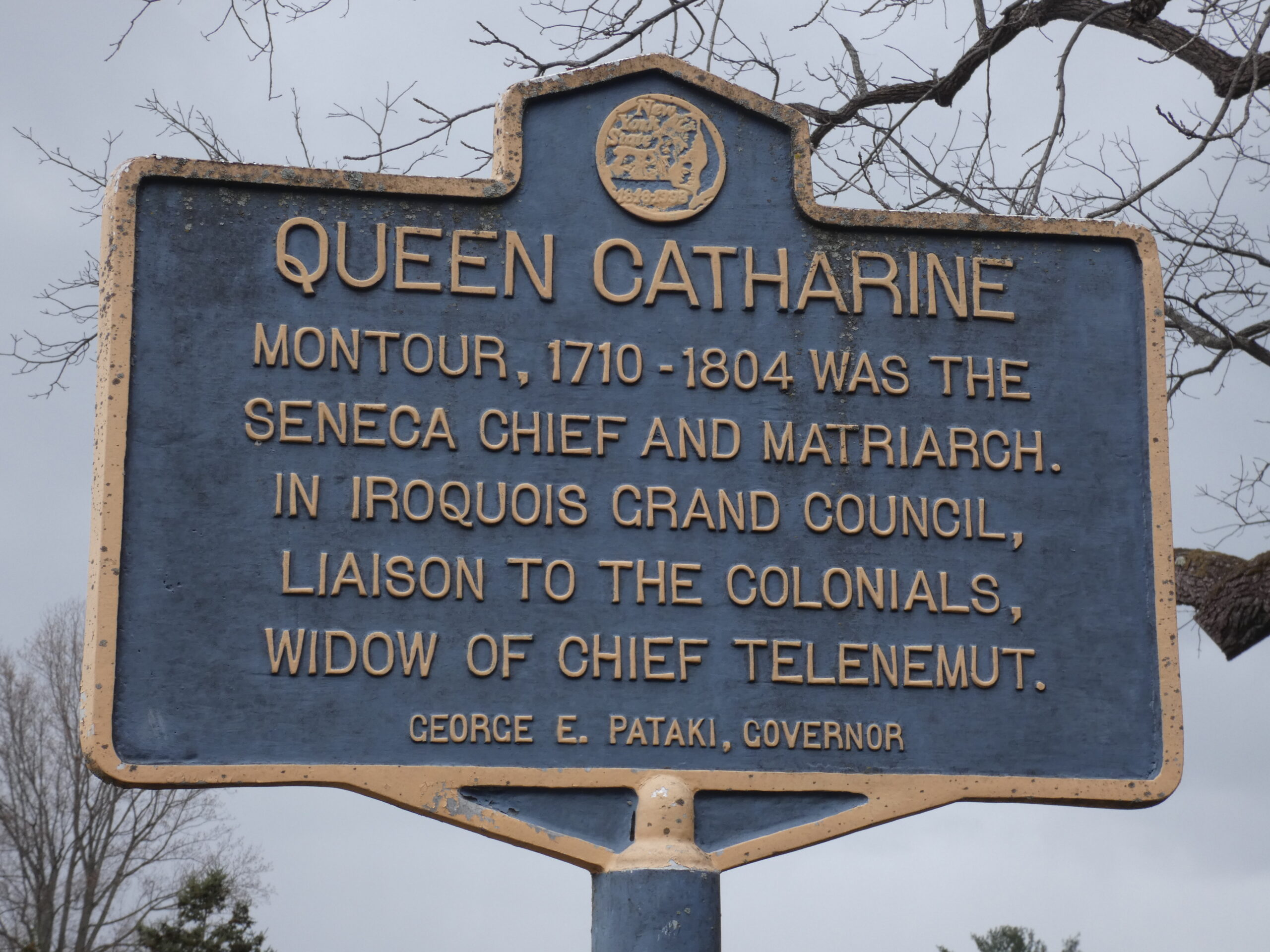
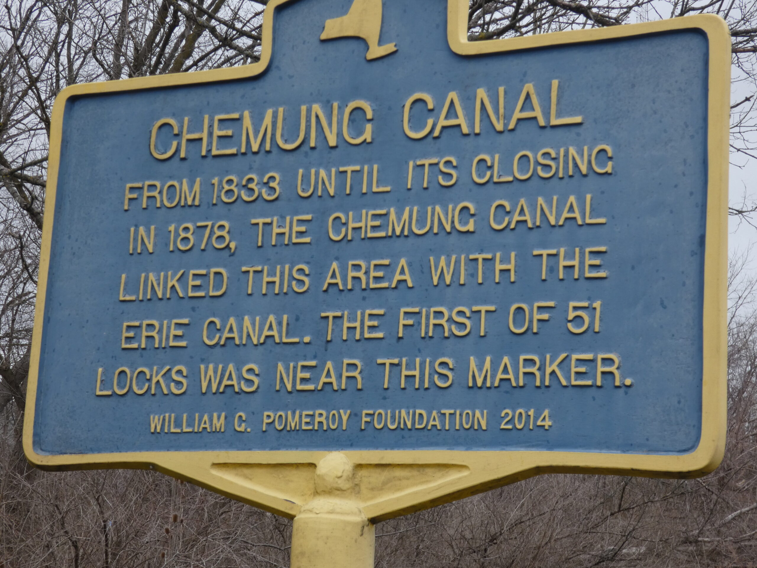
Catharine Valley Trail is a state park and recreation trail which is located in Schuyler and Chemung Counties. It runs for 12 miles between Watkins Glen State Park and Mark Twain State Park and uses the abandoned Chemung/Northern Central Railroad and the old Chemung Canal. The trail is named for Queen Catharine Montour, a prominent Seneca leader of Native American and French ancestry who lived in a village called She-O-Qua-Gah near present day Montour Falls. The village was one of the many destroyed by Sullivan’s Army in 1779. Catharine Creek, Seneca Lake’s inlet, is a popular Rainbow Trout fishing stream and runs parallel to the trail.
Meeting Place
We will all meet at the S Genesee Street parking area south of the Village of Montour Falls to explore part of the trail. Bikers will go south for an out and back of about 8-10 miles (hybrid or mountain bikes recommended); climbers will carpool to Millport and walk north the 4 miles back to the S Genesee Street parking area; the tourists/naturalists will walk south from the parking area to complete a 2 mile loop along the old canal.
Social
The social will be at an area restaurant in Watkins Glen. Location TBD.
Directions
From Watkins Glen (or Rochester and Exit 42 on the Thruway and Geneva): Take NY 14 south from the thruway, through Geneva and Watkins Glen. South of Watkins Glen, stay on NY 14 until it curves to the left. In the middle of the curve, turn right onto S. Genesee St. The parking lot is on the left in 1.7 miles.
From Horseheads and I-86 Exit 52B: Turn left onto NY-14. In 10.8 miles, turn left onto S Genesee St. The parking area will be on the right, just past the bridge over Catherine Creek.
 From Springwater: take NY Route 15 south to Route 390. Take I-390/ south to I-86 east and get off at EXIT 40 – Savona. Turn left onto NY-226 and follow it 13.22 miles to where you will turn right onto County Road 23. Go 8.03 miles then take a slight right onto County Road 28. Go 1.16 miles and take a slight left onto NY-409. Go 0.54 miles and at the stop light in the Village of Watkins Glen turn right onto NY-14.
 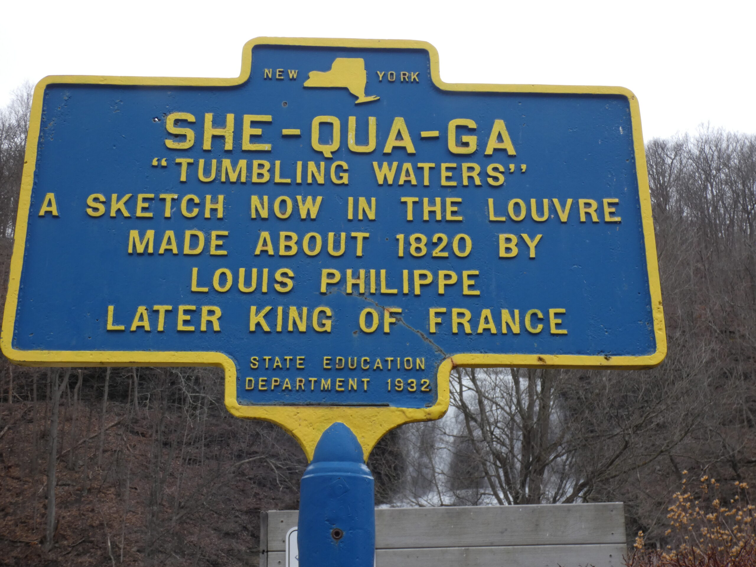 Continue on NY-14 for 4.40 miles then turn right onto S Genesee Street. In a short distance go over the bridge for Catherine Creek and the parking area will be on the right. According to MapQuest this route is 61.8 miles and the estimated driving time is 1 hour 12 minutes.
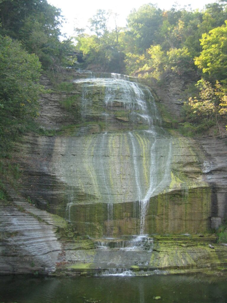
People may want to arrive early and budget extra time to stop at Shequaga Falls Park in Montour Falls, do some shopping at Famous Brands in Watkins Glen, or go birding along the Queen Catharine Marsh Trail.
More Information
The Sunday hike this week will be on Saturday 23rd April, and we will be participating in an Erie Canal Clean Sweep event in Macedon. This event is organized by someone other than Springwater Trails, so we will be joining them at the earlier time of 11:00am to walk a section of the Erie Canal in Macedon, pick up all the trash we can find and generally tidy up the towpath. We’ll limit our time at the event to something c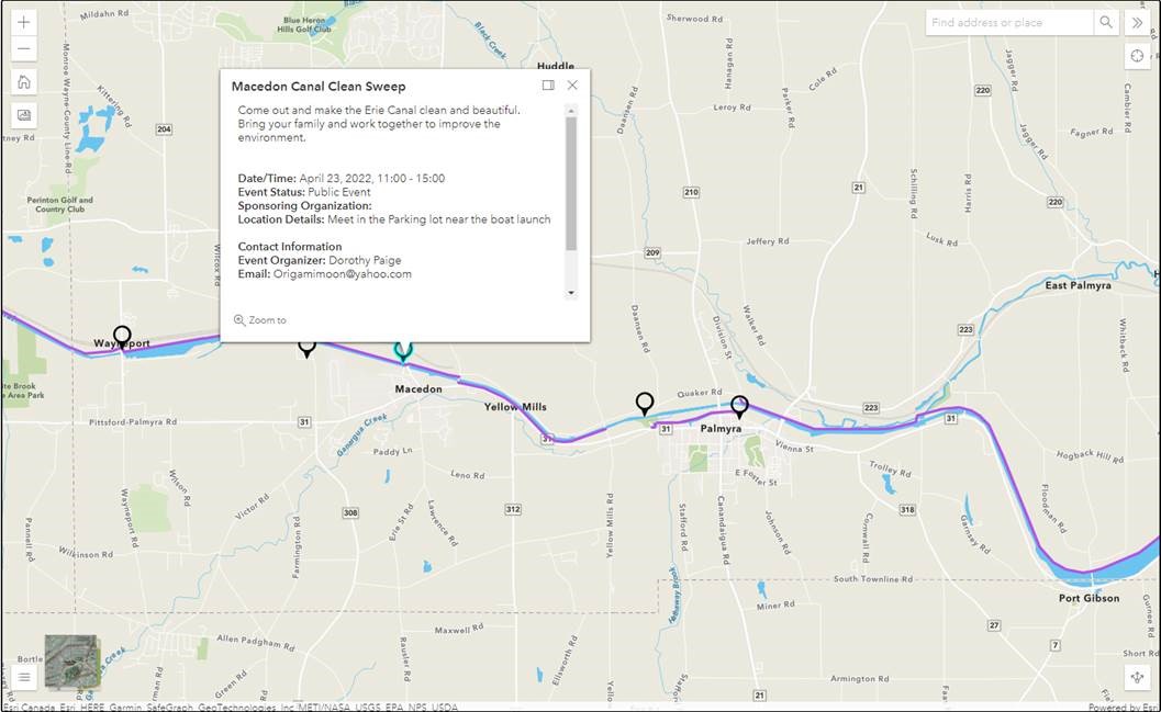 lose to our usual 2 hour hike.
We’ll meet at the parking lot near the boat launch in Macedon – See the map provided by the event organizer.
Please bring trash bags, secateurs and work gloves.
The Social: We’ll organize a social during the event.
Directions. NY 31 follows the canal east from Pittsford to Macedon. In Macedon turn north on 31F – Ontario Center Rd. In 0.2 miles, just before the canal, turn left into the park. Meet at the boat launch or in the parking lot.
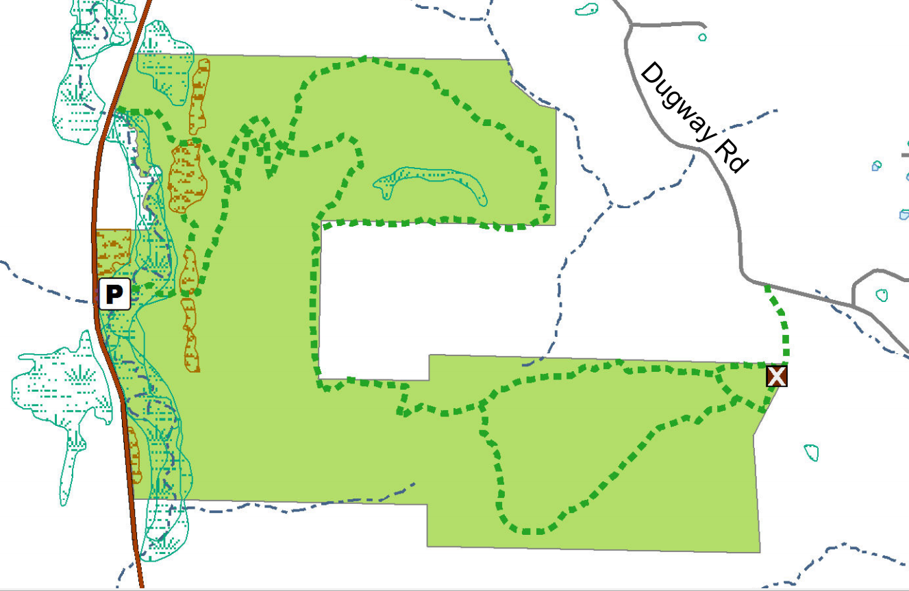
The Stid Hill Multiple Use Area is a 847 acre tract of land situated in the townships of Bristol and South Bristol in Ontario County. It is bounded by Route 64 on the west and Dugway Road on the north. Ganargua Creek, better known as Mud Creek, flows along Route 64. At one time, Stid Hill was productive sheep and cattle grazing land. Today the grazing has been eliminated. The mixture of steep hills, ravines, gullies, gorges, woods, and open areas create scenic vistas and also provide varied wildlife habitats.
We will meet at the Stid Hill MUA parking area on Rt. 64 at 1:45pm. Once we determine how many would like to hike the trail from top to bottom, we will leave some cars in this parking area. We will then carpool and proceed to drive up to the parking area on Dugway Rd. At this point the climbers will set out to hike back down to Rt. 64. The Tourists and Naturalists will follow the trails up at the top of the hill. The ground is uneven so you may want to bring poles. There are also very wet and muddy spots along the trail so waterproof hiking shoes or boots would be recommended. Rt. 64 runs north and south. If you are coming from the north starting at 5&20 head south, past Bristol Center and CR32, the parking area will be on your left. If you reach Bristol Mountain Ski Area, you have gone too far. From the south head up Rt. 64 past Bristol Mountain Ski Area, and the big wooden sign that says Stid Hill, you will see the parking area on your right.
Though the trails were well marked at one time, there hasn’t been much trail maintenance recently. The trail markers are difficult to follow and sometimes deceptive, and they disappear completely over the crown of the hill. The going will be very wet in places over the crown.
The Meeting Place
We will meet at the Stid Hill MUA parking area on Rt. 64 at 1:45pm.
Getting There
Route 64 runs north-south, so there are only two direction of approach.
From the north, (Honeoye and Bloomfield) starting at Route 5 & 20 in Bloomfield, come down Route 64. 3.0 miles south of Rt 20A and 1.4 miles past Bristol Center (and CR 32), turn left on Dugway Road. If you come to a Stid Hill MUA parking area, you’ve come too far south – turn around and try again.
From the south, starting at Bristol Springs for 6.4 miles, come up Route 64 past both Stid Hill parking areas, then turn right on Dugway Road. If you come to Bristol Center you’ve come too far north.
From Springwater, Google Maps recommends heading north to 20A through Honeoye, then south on 64.
From Wayland, the recommendation is to take Rt 21 through Naples to the east end of Dugway Rd (4.5 miles north of the intersection with NY 64). The trail head is 1.2 miles west on Dugway, (Dugway is paved to the Bristol/Canandaigua town line).
Dugway Road is a good dirt road. The trail head is exactly 2.0 miles from the Route 64 junction. It’s easy to miss – it’s just a widening of the road after a sharp left turn. The trail head is on the right of the road and marked with a discreet sign a little too far from the road. Please park carefully. There isn’t much parking space to be had.
The Social
We’ll go to Lock Stock and Barrel on Route 64 just north of Bristol Mountain for the social after the hike.
Looking for brochure.or mailing list so I can receive it in the mail.
Nothing opens up for mailing list.
There’s all kinds of very bizarre ads and post for viagra and other drugs above on calender page.
Please let me know if there’s a brochure available