
Hikes led by Springwater Trails are generally held on Sunday afternoons and appear in this calendar in green.
| Sun | Mon | Tue | Wed | Thu | Fri | Sat |
|---|---|---|---|---|---|---|
| A First Day Hike Along Canadice Lake 10:00 am A First Day Hike Along Canadice Lake Jan 1 @ 10:00 am – 12:00 pm  The Hike: Start the New Year the way you mean to go on – come for an inspiring hike along Canadice Lake! This is an easy, 1.8-mile each way hike along the shore of the lake; the trail is level … Continue reading | ||||||
| Crescent and Seneca Trails 2:00 pm Crescent and Seneca Trails Jan 9 @ 2:00 pm – 4:00 pm Our hike this Sunday will be on the southern portion of the Crescent Trail in Perinton, NY. The Crescent Trail is a system of footpaths within the Town of Perinton suitable for uses such as hiking, cross-country running, snowshoeing, nature … Continue reading | ||||||
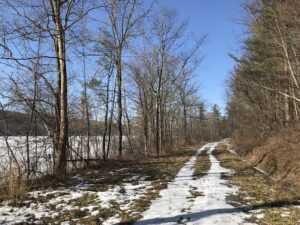
| Genesee Valley Greenway – North from Avon 2:00 pm Genesee Valley Greenway – North from Avon Jan 16 @ 2:00 pm – 4:00 pm 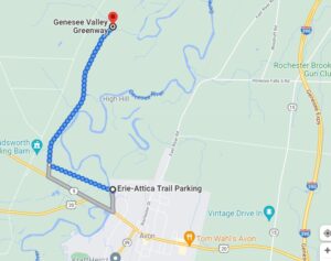 The Genesee Valley Greenway State Park is a 90-mile open space corridor that follows the route of the Genesee Valley Canal (1840-1878) and the Pennsylvania Railroad Rochester Branch (1882-1963) from the Erie Canalway Trail in Rochester’s Genesee Valley Park to … Continue reading | ||||||
| Schribner Valley Bonfire 2:00 pm Schribner Valley Bonfire @ Hopkins Yard Jan 23 @ 2:00 pm – 4:00 pm 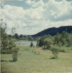 Our Sunday hike this week will be on private property around the Schribner Valley in Springwater. In order to adjust to weather conditions on the day of the hike, the plan below may need to change. This plan has been … Continue reading | ||||||
| Harriet Hollister Spencer Park 2:00 pm Harriet Hollister Spencer Park @ Main Parking Lot Jan 30 @ 2:00 pm – 4:00 pm Please join us this Sunday for a cross country ski, , snowshoe or hike, while exploring a hiking site not far from Springwater. A few years ago New York State acquired several new parcels of land to the south of … Continue reading Harriet Hollister Spencer Park 2:00 pm Harriet Hollister Spencer Park @ Main Parking Lot Jan 30 @ 2:00 pm – 4:00 pm Please join us this Sunday for a cross country ski, , snowshoe or hike, while exploring a hiking site not far from Springwater. A few years ago New York State acquired several new parcels of land to the south of … Continue reading |
The Genesee Valley Greenway State Park is a 90-mile open space corridor that follows the route of the Genesee Valley Canal (1840-1878) and the Pennsylvania Railroad Rochester Branch (1882-1963) from the Erie Canalway Trail in Rochester’s Genesee Valley Park to the Village of Cuba in Allegany County. The Greenway will eventually extend to Hinsdale in Cattaraugus County. This Sunday’s hike will start at the Erie-Attica Trail parking area on Farmers Rd in Avon, as parking is limited at the road crossings of the Greenway itself.
All groups will do a 2 hour out-and-back hike or ski, depending on conditions. The trail is flat for almost the entire distance, with minor hills at the trail intersection and a farm road crossing. The Greenway is often popular with snowmobilers, which can create a rough skiing surface.
All groups will head west on the Erie-Attica Trail across the Genesee river bridge and continue for 1.1 miles to the Greenway intersection. Several sets of bridge abutments are visible along this stretch, with the largest marking the bridge which carried the Erie-Attica Railroad over the Pennsylvania Railroad. Interested hikers may find the planning study report for the Erie-Attica Trail of interest.
All groups will turn right (north) on the Greenway and continue until the turn-around time. The views in this area are at risk from the proposed Horseshoe Solar Array which will likely start construction soon in Caledonia and Rush.
Following the hike, join us for a social hour at The American Hotel in Lima, famous for their soup selection.
Directions to the Farmers Rd Parking Area
From Springwater: Head north on NY-15A for 18.8 miles to Lima. Turn left at the light onto 5 & 20 and travel 7.6 miles west (through the traffic circle in Avon) to Farmers Road on the right just before the Genesee River Bridge. Follow Farmers Rd for half a mile, passing through the underpass under the trail. The underpass may have a pool of water under it. The parking area is on the north side of the underpass.
From Naples: Head west from Naples on CR 36 for 14 miles to Route 20A in Honeoye. Turn left and travel 1.5 miles. Turn right onto Big Tree Rd, travel 3.5 miles to Route 15A. Turn right and continue to Lima, following Springwater directions to trail parking.
From all points north: Take Route 390 to Exit 10 (Avon). Turn left onto Route 20 west and continue through traffic circle in Avon and to Farmers Road (3.5 miles)
The American Hotel is on the corner of Route 20 and Route 15A in Lima. Turn left at the exit from Farmers Rd and continue for 7.6 miles to the light in Lima.

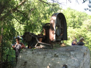
Pond from the cabin as seen in 1966.
Our Sunday hike this week will be on private property around the Schribner Valley in Springwater. In order to adjust to weather conditions on the day of the hike, the plan below may need to change. This plan has been updated to reflect the heavy snow on the ground as of Wednesday. We highly recommend snowshoes or skis to best enjoy the snow – poles will be valuable to everyone.
There will be four routes for Climbers, Tourists, Naturalists and Skiers. Hikers and snowshoers can enjoy the first three routes. The skiing trail has been marked, but will be led by a volunteer on the day of the hike. A map will be provided, but it is important to follow the ski track to avoid getting lost.
Please note that these hikes are on private trails with various levels of maintenance. You will need to step over some recently fallen trees. With the deep snow each step should be done carefully.
All hikers will meet at our house. There is parking available on the driveway in front of the garage, and also on the road, both around the intersection and turning to the right on Schribner.
All trails will start up our open field. Follow the tracks in the snow. When tracks cross, please continue straight across without disturbing the crossing trail so the other group can also follow their trail.
 The Naturalists will head up hill along a trail near the road. Upon reaching the top of the field. A left turn will take us to a second field along a Red Pine forest planted in the early 1930s. From there, we will follow the edge of the valley to our A-frame built back in 1962 from logs cut on the property, and then by the parent White Pine which was out in an open field in the 1950s. This hike will be about 2 miles with an over elevation change of 200 feet.
The Climbers and Tourists will head up the valley, crossing onto our neighbors property. We will curve around crossing the valley following logging trails. After returning to our woods, the climbers will turn right heading up to the top of the hill. They will definitely earn their name on this climb, but the reward will be that “its all down hill from there”. The tourists will continue straight on a more level trail.
The Skiers will also head up the field for a view. Taking advantage of gravity, they will come back down the field, then head down past the old cabins and climb up the other side of the valley. A left turn will take them along the old farmer’s road across onto another neighbors who has given us permission to enjoy the snow. Follow the trail as it turns right and returns on the uphill side of the woods. Another right turn will head down the hill – this will be the steepest hill on the route and likely a good time to practice carrying skis on your shoulders. From the creek, follow your tracks up and continue straight back to the house.
Following the hike, all hikers are welcome to join us around a bonfire for a dish-to-pass social. If the weather doesn’t cooperate, we will move the social inside with a fire in the stove. Please bring a dish to share, or a personal sandwich depending on your risk tolerance. Chilled drinks will be available, or bring your own beverage.
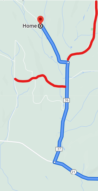
Warning: Schribner and Giles roads are not plowed to allow travel to our house from Strutt St in Springwater. Assuming there is ANY snow on the ground, you must come down Tabors Corners Rd to Schribner Rd. Set your GPS to “Tabors Corners and Schribner Rd, Springwater, NY“.
From Springwater: Head north on NY 15A from the light. Take the first right onto Wheaton Hill Rd. Go all the way to the top of the hill and the stop sign at the tee. Turn right on Wetmore Rd. At the next stop sign, turn right onto Tabors Corners Rd. In 3.5 miles turn right onto Schribner Rd. In 1.0 miles, the driveway is on the left at the intersection between Schribner and Giles Roads.
From Wayland: Head east on NY 21 North toward N Cohocton. In 3 miles from the light in Wayland, turn left onto (Steuben) CR 37 (Tabors Corners Rd). In 2 miles, turn left onto Schribner Rd. In 1 mile, the driveway is on the left at the intersection between Schribner and Giles Roads.
From N Cohocton and Naples and Canandaigua: Take NY 21 South through Naples and N Cohocton toward Wayland. In 4.5 miles from the right turn in N. Cohocton, turn right onto (Steuben) CR 37 (Tabors Corners Rd). In 2 miles, turn left onto Schribner Rd. In 1 mile, the driveway is on the left at the intersection between Schribner and Giles Roads.
Please join us this Sunday for a cross country ski, , snowshoe or hike, while exploring a hiking site not far from Springwater. A few years ago New York State acquired several new parcels of land to the south of Harriet Hollister Spencer Park, linked to the main park by an established snowmobile trail called C4.In the past, we’ve hiked the section of the C4 trail closest to the main park, and this Sunday we will snowshoe and hike from the parking lot, following Ruthies trail, to Chalet trail to C4 off Doremus trail. We will follow C4 to a point where we will turn onto a old single track hiking trail(red dashed) that crosses the “Sidewinder” trail through the south east section of the park. we’ll follow this around and return back to the parking lot via the single track trail (red dash trail) which runs parallel with the overlook road.
Skiers will start out at the parking lot and may choose to take any of the many trails in the park or venture out of the main park on C4. This is a challenging ski as there are a few uphill climbs but finishing with a nice view out in a wide open field. Skiers can return to the main parking area by returning back on C4.
Wear proper clothing according to prevailing weather conditions . As always, bring water, skies and poles good hiking footwear, snowshoes and poles if you typically use them. The trail is gently rolling – no especially steep sections.
Social: After the hike we will ??
Directions:
From Springwater and Wayland – take Route 15A North from Springwater, turning right on Wheaton Hill Road. Take a left on Canadice Road (County Road 42), forking to the right when County Road 42 divides off from Canadice Lake Road. Make the next right, on Tibbals Road (formerly Town Line Road). In 1.0 miles, Take the first left onto Ross Rd. At the stop sign (2.7 miles), take a sharp right onto Canadice Hill Rd. The parking lot will be on the left in 0.8 miles..
From Rochester or Canandaigua – go to Honeoye, and follow Route 21A (Main St. Honeoye) west toward Hemlock. About a mile out of Honeoye turn left on County Road 37. Follow County Road 37 until it makes a 90 degrees turn to the right across from the Canadice Methodist Church; at this point go straight onto Canadice Hill Road instead of County Road 37. Continue straight on Canadice Hill Road, taking the left fork at Ross Road, The parking lot will be on the left in 0.8 miles..
This week our Sunday hike will be an easy out and back, hike or x-country ski depending on the weather with an after social at the Cottage Hotel in Mendon, New York. The Mendon trail begins where we park at the Little League ball field just off Route 251 west of the four corners of Mendon, 3865 Rush-Mendon Road (Route 251). We’ll be hiking or skiing west from Mendon out about an hour with a turn-around at Chamberlain Road. That’s about 4 miles out and back. Those that wish more hiking, if time, can explore the trail east from Mendon toward Fishers.
This linear park has an interesting history. It’s a 15 mile trail extending from the Ontario County line through Mendon and Rush to the Genesee River with a north extension into Henrietta. It was purchased in 1995 for $1,300,000 and was completed and transitioned in 2004 from the old Lehigh Valley railway to a recreational trail for biking, running, cross-country skiing, hiking and horseback riding.
After the hike about 4 pm, we’ll be walking from the ball park parking lot to the four corners of Mendon to the Cottage Hotel on the north east corner. They are open until 8 pm on Sundays.
Directions: From West Bloomfield at the traffic light head north on Route 65 and in .7 miles, don’t take the curve, go straight and you will be on County Route 35 (West Bloomfield Road). Travel straight for 5.9 miles, when you reach the stop sign at Route 251, turn right. In about a mile, right across from the Ye Mendon Tavern on your left, turn right into the parking lot at the Little League Ball Field. Plenty of parking there.
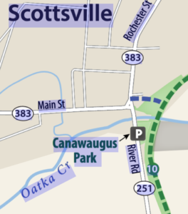
Canawaugus Park
On Sunday, February 13th we will hike/cross country ski/snowshoe a section of the Genesee Valley Greenway Trail starting in Scottsville. The trail is flat, tree lined, and follows along the Genesee river. Snowmobiles have packed the snow down on the trail which is helpful for those hiking.
The weather is likely to continue very cold, so wear appropriate clothing and carry a hiking pole for extra stability.
We will meet at 1:45 in the parking lot for Canawaugus Park Just south of Main St. in Scottsville on Rt. 251.
The after-hike social will be at Salvatore’s Old Fashioned Pizzeria a short walk from the parking lot up on Main St. in Scottsville.
Directions:
From the South (Springwater, Hemlock, Honeoye) take 15A north through Lima, to Rush. Just past the Rush Public Library bear left at the light onto Rt. 251, *go past the Rochester & Genesee Valley Railroad Museum and cross over the Genesee River. After the river crossing you will make a right and continue on Rt. 251 River Rd.. The parking lot for Canawaugus Park will be on your right.
From the North (Rochester) take 390 south and take Exit 11, follow signs for 251 W. pick up the directions from the South at the *.
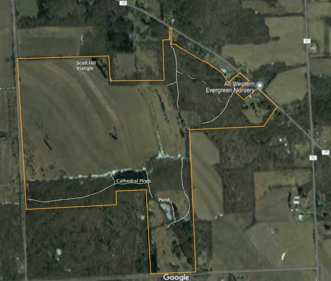 You are invited to hike on private land near the Northwestern corner of Springwater on the 248 acre All Western Evergreen Nursery & Christmas Tree Farm owned by Katherine Humphrey and daughter, Jerrianne Scheiderich. The entrance to the farm is at 6840 Liberty Pole Road (County Road 38, 1 mile from State Route 15 between Springwater and Webster’s Crossing). It is well marked and is on the high side of the road. There is parking to the left of the driveway opposite the Morton Building. Please follow the orange cones and park facing Liberty Pole Road. The hike on Sunday, February 20th will begin promptly at 2 PM. Arrive early for instructions. Hikers will be divided into Climbers, Tourists, and Naturalists. Mark, Char, and Katherine will be leading the hikes. Farm maps will be available so as to stay on the Farm. Please do not wander onto the neighbor’s lands. Please follow your snowshoe or hike leader. Select a sweep so as not to lose anyone along the way.
The following plans are subject to change based on the weather. Whether we hike or ski or snowshoe, you can count on good exercise. Our routes will include a mixture of open fields with views across the valley and forest walks with a winter perspective. Expect winter conditions. If there is enough snow, skis and snow shoes can be used. Dress warmly and bring water, poles, and snacks, as desired. Masks and social distancing are recommended, along with all the usual precautions we are trying to get used to. Most of us have had the recommended vaccines and booster shots. Beware of stones, drifts, woodchuck holes, brush and stumps. We will all meet at the farm parking lot behind the house at 6840 Liberty Pole Road.
We are planning to carpool the skiers up to Swartz Rd. From there we will head across to the Cathedral Pines, up to Story Rd and around the perimeter of the upper field to the largest trees on the farm in the Scott Hill triangle. Most of us will head back to Swartz Rd and drive back to the farm house. Those interested in downhill skiing will return on the road down to the farm house.
The Tourists on snow shoes or winter boots will head up to the field and will follow a path toward the south, around the pond and back to the cathedral pines. From there we will head around the various fields of Christmas trees, past the beautiful full grown Concolor trees on the north side of the farm in the Scott Hill triangle . From there we will head into the woods for an interesting walk back to the farm house.
The Naturalists will explore the nursery beds and several exotic trees near the residence, and then head up the road (a leisurely incline from 1200 to about 2000 feet) to the fields and possibly to the Cathedral Pines.
The tree farm was started in 1968, making 2022 the 54th year of planting trees. Participants may like to notice the many different species of Christmas trees planted and the animal tracks to ID. Please stay on trails to avoid trampling seedlings that may not be seen under the snow. You will see hardwoods, a red pine forest (cathedral pines planted over 75 years ago), Christmas tree plantations (some Concolor fir trees up to 35 feet tall), a pond, wet areas and open fields and a gorgeous view from the hill tops toward East Springwater.
After the hike, a choice of hot, home-made soups will be at the farm house. The garage area will be our shelter with the doors open. You are invited to bring a dish to pass, a folding chair, your preferred drink and stay for the social.
Directions: NOTE: If you are following your GPS to today’s hike, check that your directions actually go to Liberty Pole Road. If your route ends on Schwartz Rd, you will find you are a long way from the parking area you are looking for!
From Springwater: Go west from the Springwater light on Rt 15 North. Just past the top of the hill, turn left on Co Rd 38 (Liberty Pole Rd). The farm is on the left 1.1 miles from Rt 15 at 6840 Liberty Pole Rd.
From Geneseo: Go south on NY 63. About 6.4 miles after passing Rt 408, turn left on County Road 1 at Groveland. This road becomes CR 1A at Scottsburg (rt 256) and then Liberty Pole Rd (CR 38). It is 7.1 miles from Groveland to the All Western Evergreen Tree Farm.
From Honeoye: Take 20A west to Hemlock and 15A south to Springwater. Then follow the Springwater directions.
From Rochester: Take I390 south to Exit 9 (NY 15 / Lakeville). Turn left onto NY 15 and follow Rt 15 through Lakeville and Livonia (16.5 miles). Just past Webster’s Crossing stay straight on CR 60 when Rt 15 bears left. Take the first right off CR 60 onto Liberty Pole Rd (CR 38). The farm is on the left at 6840 Liberty Pole Rd.
————————- Change of Plans – We will meet at the trail head on the south side of the canal. See below ———
The Crescent Trail in Perinton, NY, is approximately 35 miles of footpaths starting in Bushnell’s Basin on the Erie Canal, and currently ending at Northside School in northern Perinton. Planned, developed and maintained by the Crescent Trail Association, this trail is built on state, town and private lands and connects with the Canalway trail and the Trolley trail, two multiuse trails in the town.
NOTE: Our original plans for this hike were at Indian Hill. However, ice on the trail and in the parking lot, made this hike best postponed until the trillium are out this spring. This Sunday hike has been moved to a flatter location that should not be as dangerous with ice. However, traction devices or snowshoes are highly recommended – bring extras if you would like to loan them to poorly prepared hikers.
NOTE 2: Snow is expected. Check the weather and dress accordingly. Remember to drive safely.
This Sunday we will hike a portion of the Crescent Trail along the Erie Canal and the White Brook Nature Area. We will meet at the trail head parking lot south of the canal off of Lyndon Rd. (The baseball parking lot was not plowed on Saturday, so we will avoid that.)
Three hike options will be available. All hikes will follow the road across the railroad tracks and the canal to the south side of the canal and the trail head on the east side of the road (about 2000 ft). The climbers will follow the orange trail to the northern part of the White Brook Nature Area, where we will leave the orange to follow the blue trail around the field and back to the orange and home, for a total of about 4 miles.
The tourists will follow start on the orange trail but will take the second turn left on the yellow trail, crossing White Brook and heading east along the canal. The trail ends at the Perinton town line, and returns along a blue trail at the canal’s edge. As the tourists approach the Lyndon bridge, they will have the option to continue along the canal toward Fairport, or to turn south back to the trail head, then across the canal to the ramp to the Canalway on the north side of the canal. The tourist hike leader should check a watch and plan a turn-around time on the canal path to return to the cars at 4.
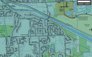
Canal and White Brook trail map. Click for full Crescent Trail map
The Naturalists will take the first left from the orange trail onto the yellow trail to head west the canal on a trail between the White Brook and the Canal. In about 1.5 miles, they will leave the canal, on a short climb to the trolley path, cross the canal on the footbridge and walk back to the cars on the Canalway on the north side of the canal for a total of about 3 miles.
If the weather permits, skiers will follow the climbers trail into White Brook.
Traction devices (spikes or spring coils) or snowshoes are highly recommended for all hikers. A nice layer of snow provides reasonable traction, but underneath is ice, making for slippery conditions at times.
Following the hike, Noonan’s on Rt 31 will be open for a brew and refreshments.
Directions to the Trail Head.
From Turk Hill Rd and Rt 31 in Perinton: Head north on Turk Hill Rd. Turn right onto Ayrault Rd at the next light. In 1.5 miles, at the bottom of a steep hill, turn left onto Lyndon Rd. Just before the bridge over the canal, the parking area is on the right.
From Springwater: From the flashing light, head north on Rt 15A for 2.7. miles. Bear right onto Old Bald Hill Rd S, then an immediate right onto Johnson Hill Rd. Continue on Johnson Hill Rd to the end. Turn left onto Co Rd 37. Stay on CR 37 for 11 miles (there is a left turn in Canadice to stay on CR 37) past Honeoye. Turn right onto Richmond Mills Rd and then left at the 1st cross street onto CR 40. After crossing 5 & 20, turn right onto Main St in Bloomfield. At the light turn left onto NY 444 for 5.7 miles into Victor. Turn right onto Main St (NY 96) then left on Church St. Continue north for 6 miles. past Lollypop Farm. Turn right onto NY 31, then left onto Aldrich Rd. The road turns left to become Ayrault Rd. In half a mile, turn right onto Lyndon Rd. Just before the bridge over the canal, the parking area is on the right.
From Rochester: Take I-490 E to exit 26, NY-31. Turn east on NY-31. In 0.4 miles, at the light, turn left onto Ayrault Rd. You will pass the Middle School and the High School before going down a steep hill. At the bottom (3.8 mi from Rt 31), turn left onto Lyndon Rd. Just before the bridge over the canal, the parking area is on the right.
From Naples: Take NY 21 north from Naples to South Bristol. Continue straight onto NY 64. In 13 miles at the light, turn left onto 5 & 20 west. In 6.8 miles turn right onto NY 444N to Victor. Turn right onto Main St (NY 96) then left on Church St. Continue north for 6 miles. past Lollypop Farm. Turn right onto NY 31, then left onto Aldrich Rd. The road turns left to become Ayrault Rd. In half a mile, turn right onto Lyndon Rd. Just before the bridge over the canal, the parking area is on the right.
From Canandaigua: Take NY 332 north to a left onto NY 96 N. At the traffic circle near Victor, take the first exit onto Lynaugh Rd. In 1 mile turn right onto Victor Egypt Rd. Continue north for 5 miles. past Lollypop Farm. Turn right onto NY 31, then left onto Aldrich Rd. The road turns left to become Ayrault Rd. In half a mile, turn right onto Lyndon Rd. Just before the bridge over the canal, the parking area is on the right.
From Geneseo: Take I-390 north to Rochester. Take exit 15 onto I-590 N. Take exit 5 onto I-490 E toward Victor and follow the directions from Rochester.
Directions to Noonan’s: Head south on Lyndon Rd. At the stop sign, turn right on Ayrault Rd. Take the first left at the top of the hill onto Mason Rd. At the light, turn right onto NY 31 W. Noonan’s is a white building on the right. Park behind the restaurant.
 This Sunday we will enjoy a leisurely stroll along the Hemlock Lake shore on the northwest section of Rob’s Trail. Temperatures are expected to rise this week, so we’re not expecting much snow cover. The lake level is high, probably still iced over, and walking on the beach is not an option, but the trail offers a good flat and mostly well-drained surface. Here and there we will encounter a minor stream to cross by either wading or jumping, so waterproof footwear and poles are advised. Just in case of lingering ice, spikes or yaktrax are a good idea too.
Meet at the north boat launch, at the end of the old east lake road, a sharp left after you first enter Rix Hill Road from Route 15A. This will be an out and back hike; Naturalists and Tourists may return at any point. At about 1.75 miles we will encounter a more substantial stream across the trail, probably too large to leap over. Any Climber wishing to proceed on Rob’s Trail past this point is advised to bring wading boots. Turning around at this point will give you a hike of 3.5 miles and a little under 2 hours.
Optional Social: Please join us at the Birdhouse Brewing Company in Honeoye – 8716 Main Street, just east of the traffic light, for craft beer and pub food.
Directions: From Springwater: proceed north on Route 15A 19 miles, then make a left on Rix Hill Road and an immediate left on Old East Lake Road, a.k.a Boat Launch Road.
From Honeoye and points east: Take Route 20A west from the Bristol Valley and Honeoye. When 20A meets Route 15A, make a left and go about .6 miles to Rix Hill Road. Make a right and then an immediate left on the dead end road to the boat launch parking area in one mile.
From Rochester and points west: Take Route 15 south from Henrietta or Route 15A south from Honeoye Falls, or Route 390 south to the Lakeville-Livonia exit, then go south on Route 15 and then east on Route 20A through Hemlock. When Route 20A turns east toward Honeoye, go straight another .6 miles and make a right on Rix Hill Road. Then make an immediate left onto the boat launch road and go to the end, 1 mile.
To the Social: From the Boat Launch parking area, return to Rix Hill Road, make a right and then a left on Route 15A. Go .6 miles and make a right on Route 20A. In about 4.75 miles you will reach the traffic light in Honeoye. A few buildings beyond the light is Birdhouse Brewing on the left at #8716.
This Sunday we will hike the western half of the Keuka Lake Outlet Trail starting at Seneca Mill and walking west to Penn Yan. The whole trail follows Keuka Lake’s outlet to Seneca Lake, starting in Penn Yan and going approximately 7 miles to Dresden, dropping 275′ along the way. The first destination will be Cherry Street (about 3.5 miles) where we’ll have cars waiting to take us back to Seneca Mill. If there is still some walking time we can continue the trail into Penn Yan. Since it’s getting on for spring then mud is likely so poles and shoe gripping devices or good boots will help.
This trail runs along the stream in a wooded ravine; it was formerly a canal towpath and later a railroad bed. It crosses the original Preemption Line and passes near the area of the first permanent white settlement of ‘The Universal Friend Jemima Wilkinson’, alongside waterfalls and the ruins of mills, factories and canal locks”.

The Meeting Place
Everyone will meet at the Seneca Mill Access parking area on Outlet Road at 2:00 PM. We will divide into two or three groups depending on how far people choose to hike in the two hours that they have. All hikers will walk west from Seneca Mill (that is towards Penn Yan); the climbers will walk to the Cherry Street access point in Penn Yan, while the naturalist and Tourists will hike for an hour and then turn back.
With the spring thaw under way the outlet should be flowing in spate, so it will be worth walking slowly and taking lots of photographs.
Some maps of the outlet trail will be available at the beginning of the hike: you can print your own map from The Friends of the Keuka Outlet Trail website here.
The Social
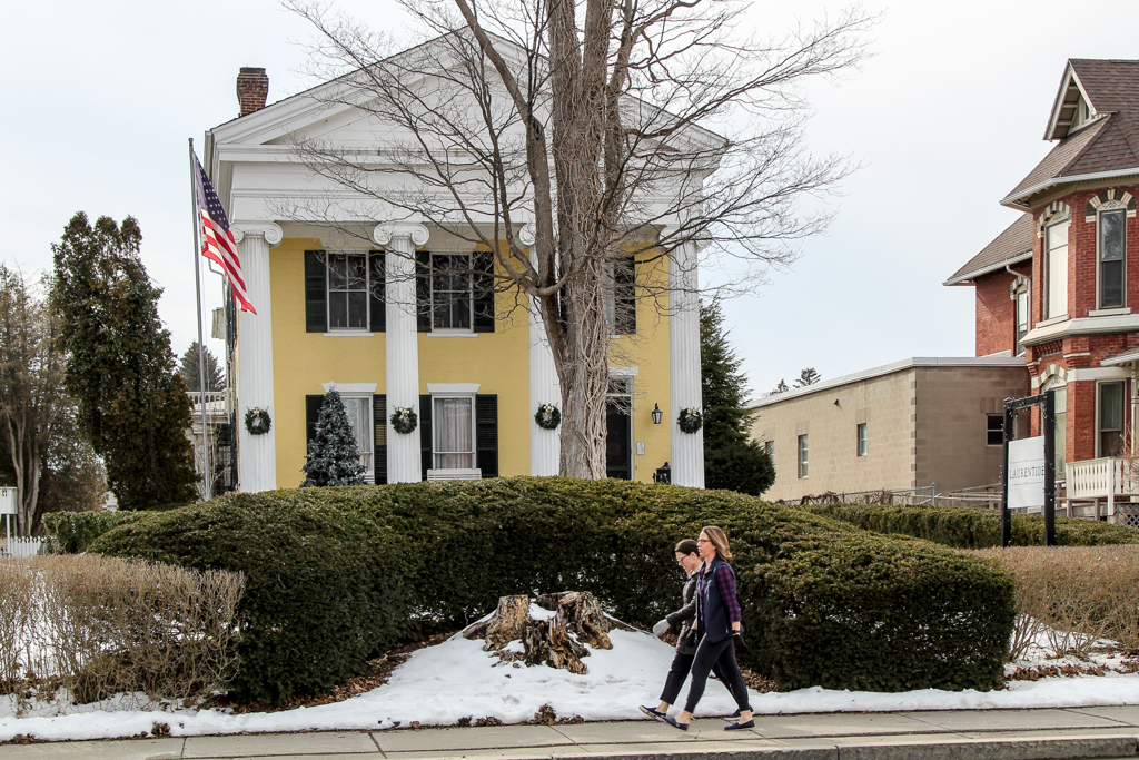
The social will be a share-a-dish affair at the Laurentide Brewing Company at 12 Maiden Lane, Penn Yan, NY 14527. This brewing company is in a barn behind the Laurentide Inn which faces Main Street in downtown Penn Yann, across from the Post Office. The Laurentide Inn is an imposing yellow civil war era building with four huge columns holding up a portico. The brewery does not serve food but we are welcome to bring anything we want with us and just buy their beer. We can gather inside if the weather is harsh, or there is a small garden with tables that we can use if it’s warm enough. There is some parking behind the inn and plenty of street parking in front of it.
Directions:
From Springwater, Wayland and Naples. Head south from Springwater on NY-15 south to Wayland, then turn left NY-21. Follow NY-21 for 12.7 miles through N Cohocton and Naples. Turn right on NY 245N across from Bob Ruth’s. Follow NY-245 for 8.9 miles to Middlesex and take a slight right turn onto NY 364E. In the Village of Penn Yan, turn right onto Liberty St., turn left onto Clinton St (State Route 54 North) and follow it 2 miles, turn right onto Bentley Rd (which becomes Bell Road) and go for 1 mile, turn left onto Outlet Road and go for .3.5 miles,; the parking area is on right. Don’t park at the rail on the left – that is set aside for horses and buggies.
Looking for brochure.or mailing list so I can receive it in the mail.
Nothing opens up for mailing list.
There’s all kinds of very bizarre ads and post for viagra and other drugs above on calender page.
Please let me know if there’s a brochure available