
Hikes led by Springwater Trails are generally held on Sunday afternoons and appear in this calendar in green.
| Sun | Mon | Tue | Wed | Thu | Fri | Sat |
|---|---|---|---|---|---|---|
| Ontario County Park 2:00 pm Ontario County Park @ FLT Entrance Dec 2 @ 2:00 pm – 4:00 pm  Ontario County Park is really a hidden gem in the area, providing hiking, biking, cross country skiing, fishing (no hunting), and camping or picnicking opportunities depending on the season. This Sunday we will explore some winter hiking trails we haven’t … Continue reading | ||||||
| Historic Geneseo Village Walking Tour 2:00 pm Historic Geneseo Village Walking Tour @ Municipal Parking Lot off Main Street Dec 9 @ 2:00 pm – 4:00 pm  This Sunday we will take a somewhat leisurely tour of Geneseo Historic District landmarks and properties described in the Association for the Preservation of Geneseo’s brochure ” A Walking Tour of Geneseo, New York Village Center”. At each of the … Continue reading | ||||||
| FLT Letchworth Branch – 4th in the Series 2:00 pm FLT Letchworth Branch – 4th in the Series @ Access F Dec 16 @ 2:00 pm – 4:00 pm This Sunday’s hike is the 4th in our series on the Letchworth Branch. This hike will join the trail at Access Point F and will follow the trail to Access H for a 5 mile hike. The Tourists and Naturalists … Continue reading | ||||||
| No hike – Christmas 2:00 pm No hike – Christmas Dec 23 @ 2:00 pm – 4:00 pm  This is the Springwater Trails holiday card from 2012. Enjoy your holidays and we will see you on the trails December 30th, January 1st and all next year! | ||||||
| Hike out of 2018 2:00 pm Hike out of 2018 @ Sugarbush Hollow Dec 30 @ 2:00 pm – 4:00 pm Please join us on the last Sunday of 2018 for a hike on the Springwater Trail at Pardee Hollow, followed by our holiday social at John’s house. Bring you extra cookies and a dish to pass (or make a contribution … Continue reading |
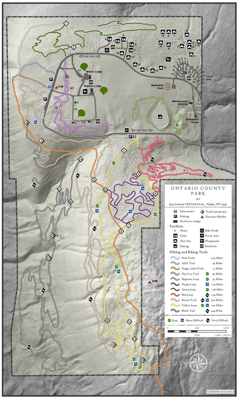
2017 Map
Ontario County Park is really a hidden gem in the area, providing hiking, biking, cross country skiing, fishing (no hunting), and camping or picnicking opportunities depending on the season. This Sunday we will explore some winter hiking trails we haven’t visited much over the years. You should expect some interesting views around the park..
The weather is very interesting right now. On Tuesday Mark and I did a prehike in a howling gale with blowing snow up on top of Gannett Hill. The temperature up on the hill was 29° when the village of Naples was us at 34° and no snow. On Thursday for a second prehike, we ran into snow drifts up to 2 feet deep and invisible trails covered with snow. And now weather forecasts are calling for rain on Saturday, and light rain with temperatures around 50 on Sunday. Right now is a good time to get our you rubber boots and your snow shoes and cross country skis, so you are ready for whatever comes.
Here are our current plans for Sunday – these may change depending on the conditions on Sunday.
The Climbers will explore the black trail on the west side of the park. This trail weaves along near the steep west hill of the park. It’s not clear we were actually on the trail on Thursday, but the hiking was generally quite easy and we have marked a trail with yellow tape so we won’t get lost.
The Tourists and Naturalists will explore the green trail on the north side of the park. Mark will lead this hike which means we may not always know where the trail is.
Following our hike, all interested hikers will gather at the Neapolitan in Naples for Pizza or hot sandwiches.The Neapolitan is located on the west side of Main St one block south of the high school.
Directions: The easiest route is to take NY 64 to Bristol Springs and turn west on Gannett Hill Rd. There is a sign indicating Ontario County Park. At the top of the hill turn right onto South Gannett Hill Road. The park entrance is straight ahead. Follow the park road for about .5 miles to our meeting place which is the parking area along the park road near the information kiosk at the Finger Lakes Trail trail-head.
Parking is available off Main St between Center and Chestnut streets or at the meters on Main St (no cost on Sunday). We will meet on the west side of Main St at the Memorial Fountain at the intersection of Main and Center streets.
Although there will be a few available to share, you may want to bring your own copy of the brochure with you. Here is the link.
As time allows, some people may also want to visit the Roemer Arboretum on the SUNY Geneseo Campus and/or the Genesee Valley Conservancy’s Island Preserve across from Geneseo Central School.
An after hike social will be held at The Village Tavern, 137 Center Street, Geneseo (Menu).
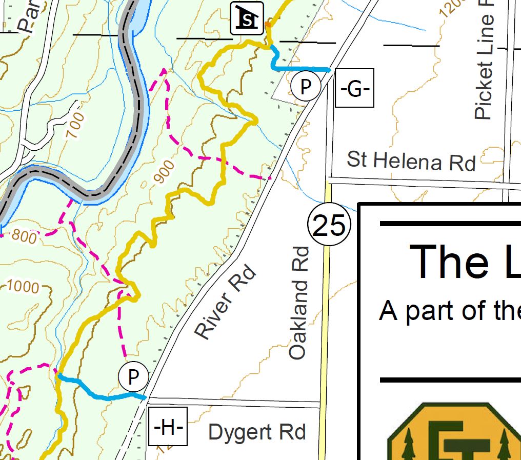
This Sunday’s hike is the 4th in our series on the Letchworth Branch. This hike will join the trail at Access Point F and will follow the trail to Access H for a 5 mile hike. The Tourists and Naturalists will exit early at Access G for a 2 or 3 mile hike. For hikers tracking our progress on this branch trail, you will note that we have skipped the section from E to F. This section is six miles with no early exits – so, we are postponing that hike until March and daylight savings time when less snow should allow us to finish the hike well before sunset.
Starting from shoulder parking at Access F, all hikers will follow the blue trail into the main yellow trail. The climbers will turn left onto the main trail. In a mile and a half, we will stop at a shelter for a sip of water from our individual supply of water which all hikers are expected to carry on all hikes. In another mile, we will cross the abandoned St. Helena Rd. This road carried traffic to a bridge across the Genesee to a hamlet of St. Helena on the west side of the river. At the time of the Civil War, St. Helena had 90 students in its school, but in 1884 and again in 1904, the bridge was washed away by ice jams. In 1920, there were just 6 families left, and the school was closed. The last resident left in 1948. The Mt Morris Dam was completed in 1952 and contained the hamlet within the lake that forms behind the dam during floods. About two miles after crossing the St Helena road, we will turn left onto the blue trail and hike out to an awaiting car to carry us back to our cars at the trail head.
The Tourists will follow the same access trail as the climbers to the main trail, but will continue straight across and continue of the park trail to the edge of the river flats or as far as the hikers wish to go. If they hike for 0.6 miles, they can reach a large old sycamore tree, the largest tree in Letchworth. The tourists will then return on the same park trail back to the yellow trail, and will turn right to follow the hikers (and naturalists). About 500 feet past the shelter, the tourists will leave the branch trail on a blue access trail and hike out to another waiting car on River Rd which will transport them back to cars at the trail head.
The Naturalists will also follow the blue trail into the yellow trail. Turning left they will follow the climbers to the shelter. A tenth of a mile past the shelter, the Naturalists will turn left onto another blue access trail to Access G on River Rd. The Naturalists should wait for the Tourists behind them and share the car ride back to the cars Access F.
Following the hike, please join us for a social at the Sunrise restaurant in Dansville. Prior to the hike, the tourists and naturalists should confirm that they plan to meet the climbers at the restaurant. They can let the restaurant know the number of climbers that should be expected about a half hour later than the tourists and naturalists.
Directions
From Springwater: Take NY 15-N west from the light in Springwater. At the top of the hill and around the curve, turn left onto Liberty Pole Rd (CR 38). Continue straight across Reed’s Corners Rd where it becomes CR 1A, and across Stagecoach Rd where it becomes Springwater-Scottsburg Rd and finally across NY 256 where it becomes Groveland-Scottsburg Rd (CR 1). Finally, in 8.1 miles from NY 15, in Groveland, turn left onto NY 63. Take the first right onto NY 258 (Flats Rd). At the end of that road, turn right onto NY 36. After the Correctional Institution. take the second left onto Dutch Street Rd. In 1.3 miles, turn right onto Ridge Rd. Turn left onto NY 408. Go past Frost Rd and turn left onto Hoagland Rd. At the tee, turn left onto River Rd. Parking is on the right just past the next street (Picket Line Rd).
From Wayland: Take I-390N through Dansville. Take Exit 6 for NY-36. Turn left onto NY-36. After the Correctional Institution. take the second left onto Dutch Street Rd. In 1.3 miles, turn right onto Ridge Rd. Turn left onto NY 408. Go past Frost Rd and turn left onto Hoagland Rd. At the tee, turn left onto River Rd. Parking is on the right just past the next street (Picket Line Rd).
From Mt Morris: Take NY-408 south from Main St. In 2.5 miles, bear right onto River Rd. Continue on River Rd for 5.5 miles, past Ridge Rd, Frost Rd and Hoagland Rd. Just past Picket Line Rd, parking is on the right shoulder of the road.
From Nunda: Take NY 436 west from route 408. In 3.1 miles, turn right onto Oakland Rd. At the end, bear right onto River Rd. Parking will be on the left shoulder in about 3/4 mile.
Directions to Sunrise Restaurant: Follow River Rd south. In 0.7 miles, take a slight right onto Oakland Rd. Turn left onto NY 436. In 15 miles, continue straight onto NY-36. At Main St, turn left. Park on the street in front of the restaurant, or take the driveway past the restaurant to the parking area behind the restaurant.
 This is the Springwater Trails holiday card from 2012.
Enjoy your holidays and we will see you on the trails December 30th, January 1st and all next year!
Please join us on the last Sunday of 2018 for a hike on the Springwater Trail at Pardee Hollow, followed by our holiday social at John’s house. Bring you extra cookies and a dish to pass (or make a contribution to the social fund) and a beverage and join us at John’s for some good conversation and some music – you will be welcome to contribute your own rendition of favorite holiday tunes.
We will meet at the entrance to the Springwater Trail on Pardee Hollow. Lets park on the right hand side heading down hill from the Sugar Shack. The Tourists and Naturalists will carpool up Coates Rd to the seasonal entrance to the trail. They will follow the orange access trail into the blue trail, then turn left and climb to the fields at the top of the hill to enjoy the views. After walking the fields, head back down the blue trail to the cars on Pardee Hollow. Climbers will hike up the blue trail from Pardee Hollow, to the fields at the top. We will then explore the Trillium Trail and head back down the way we came up. This will include more climbing than the Tourist route.
Linda and I did a pre=hike on Friday and the temperature was around 50 and the trail had many slippery leaves to watch for. Sunday is predicted to be at or below freezing, so conditions may change. Poles are recommended and possibly traction devices on your feet, although they may quickly become clogged with leaves. Dress in layers so you can cool down on the way up and bundle up on the way down.
Directions: Please click here for directions,

What better way to kick off the New Year than by getting a jump start torching off those holiday calories in the great outdoors. Springwater Trails is leading one of the dozens of sponsored hikes held each New Year’s Day on public lands across the Empire State.
Local volunteers and staff from DEC and State Parks will be leading family-friendly walks and hikes. The hikes range from one to five miles depending on the location and conditions. Check out the great hikes available.
Our hike will be along Canadice lake. The trail will be easy to moderate difficulty. There are approximately 14 miles of marked hiking trails on Hemlock-Canadice State Forest. The trip length will be family-friendly and determined by participants.
Please dress appropriately for the weather. Bring snowshoes if there is snow. Bring hiking poles, wear good boots and carry water with you.
Directions: v Springwater: Head north on NY-15A. In 7.6 miles, turn right into Purcell Hill Rd. Go up and over the hill (1.2 miles). At the bottom but before the lake, the parking is on the right.
From Rochester and Hemlock: head south on Ny-15A. Go through Hemlock NY. In 3.5 miles, turn left onto Purcell Hill Rd. Go up and over the hill (1.2 miles). At the bottom but before the lake, the parking is on the right.
 Please join us on the first Sunday of 2019, Jan 6, for a hike at Robs Trail, a trail built in 2016 by the Nature Conservancy. The trail has beautiful views, two lovely bridges over bubbling streams and meanders on moss covered trails along stream gorges. Stop and look at the descriptive map that shows all the cottages once located on this pristine lake.
We will meet at the entrance to the Robs Trail on Route 15A. The trailhead has a large sign at the parking lot that is 3.9 miles from Rix Hill rd at the North End of Hemlock lake. The Tourists and Naturalists
Following the hike, please join us for a pot-luck social at Mary’s. Directions available at the hike. Bring a dish to pass and your own beverage.
For a more detailed description of Rob’s trail, check out their website.
Directions to the trailhead:
From Springwater: Take Rt 15A north. In 6.1 miles, the parking lot is on the left just after the north end of Old Bald Hill Rd South.
From Hemlock: Take Rt 15A south. At 4.7 miles south of the 20A/15A intersection south of Hemlock, the parking lot is on the right.
Directions to Decker Rd from the Parking area: Head north on NY-15A N for 3.9 mi. Turn left onto Rix Hill Rd. In 1.2 mi merge onto Blank Rd. Take the first left onto Cleary Rd. In 2.2 mi turn left onto NY-15 S. Take the third right (in 1.5 mi) onto Decker Rd.
Hike Description – Hike at Mendon Ponds Winterfest 2019
 Once again, we host our mid-January hike at Mendon Ponds Park, coinciding with Monroe County’s 24th annual Winterfest. The park will be teeming with cold-weather fun activities between 10:30 and 4, including programs on nature and winter sports for kids and adults – see https://www2.monroecounty.gov/parks-winterfest for full details.
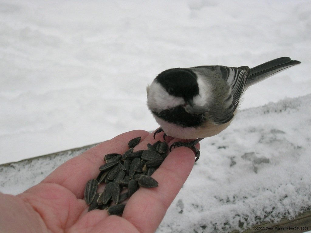
Dena sent a picture she took back in 2009. She fed the chickadee with her left hand and took the picture with her right hand – what a challenge!
We will meet at 1:45 at the Nature Center Lot – the first lot on the right, just inside the Pond Road entrance off Route 65/Clover Street. Come earlier if you’d like to take advantage of the refreshments from Chef’s Catering, the free coffee and hot chocolate, or the Wild Wings Birds of Prey demonstrations, all at the Nature Center, or for other free activities scheduled throughout the park. We will all start out hiking the Birdsong and Swamp Trails (2 miles), and the Naturalists will return to the Nature Center after the loop. From the Birdsong Trail midpoint, the Climbers and Tourists will continue around the Quaker Pond Loop Trail for another 2.7 miles, returning to the Nature Center by the rest of the Birdsong/Swamp Trail, for a total of 4.7 miles. Both trails are relatively level and pass through an interesting variety of habitat types. The Birdsong Trail is well known for its tame chickadees, and if you bring a handful of seeds or nuts, you may be rewarded with birds eating directly from your glove!
The Seneca Siberian Husky Club’s Sled Dog Races are scheduled for the Southern Meadow Trail at 11-1, though the forecast is questionable for snow. Anyone with other dogs, please keep your dog on a short leash throughout the day, and stay away from the race course during these hours.
Social: Afterwards please join us for the social at the Brewery Pub and Grill at 8 West Main Street, Honeoye Falls, overlooking the picturesque falls.
Directions:
From Springwater: Head north on 15A for 21.6 miles through Hemlock and Lima. Take a right at the exit to Honeoye Falls. Stay on W Main St into the village where you will pass the Brewery Pub and Grill on the right at the intersection with NY 65 (1.9 mi). Continue straight onto NY 65 for 4.4 mi. (At 2 miles, you will go around a traffic circle. Stay on NY 65.) Turn right onto Pond Rd at the park entrance. The Nature Center is just inside the entrance, on the right.
From Honeoye, take US 20A west and head north on CR 37 for 8.2 miles to W Bloomfield. Continue straight on NY 65 for about 3 miles, and make a right on Quaker Meeting House Road just before you come into Honeoye Falls. When Quaker Meeting House Road ends at Route 251 (Rush-Mendon Road), go left and then right on Route 65/Clover Street. The Pond Road entrance to the park is about 2 miles to the north, on the right. The Nature Center is just inside the entrance, on the right.
From Rochester: Exit I590 at Monroe Ave toward Pittsford. Turn right (south) onto NY 65 (Clover St). In about 6.7 miles you will come to the Canfield Road entrance to the park – this is not the one you want. Continue another 1.5 miles, then turn left onto Pond Rd, the second entrance into the park. The Nature Center is just inside the entrance, on the right.
Directions to the Social: From the Nature Center lot, go left back to Route 65/Clover Street. Make a left and go 4.4 miles to the village center of Honeoye Falls. The Brewery Pub and Grill is on the left, just after the traffic light.
CANCELED: Due to the storm yesterday and the low temperatures expected this afternoon, Springwater Trails will NOT be leading a hike today. Stay warm, drive only when it is safe, but take some time this afternoon to enjoy our winter weather!
This hike at Letchworth will be rescheduled for February.
If I can count, this Sunday is our 5th hike in our Letchworth Branch series. I would love to hear your comments about this series, and also whether you would like us to do more “Series” hikes.
Weather predictors are calling for 12 inches of snow on Saturday, so please check your driveway and the website before you head out to this hike. If conditions look bad Sunday morning, we will post a cancellation on the website.
Linda and I did a pre-hike on Thursday. It was cold with very little snow. We found several streams that could be a challenge to cross. Slippery ice and steep banks, so we had to walked downstream to an easier crossing.
If we get 12 inches of snow on Saturday, everything will change. I don’t recommend skis, but snowshoes, cleats, and poles will all be useful. The description below is based on conditions on Thursday.
All hikes will start at Access Pt H at the corner of Dygert Rd and River Rd on the east side of Letchworth State Park. We are planning three routes for this hike, depending on who comes and the conditions. The Climbers will follow the main trail from Access H to G for a 3.6 mile hike. The Tourists will use park trails (old roads) at the start and end of the hike to reduce the length to about 2.7 miles. Finally, the naturalists will follow the Park trail, then explore the main trail as time and interest permit, or will to a road walk, returning to the cars they way they went in. This hike would vary between 1 and 2 miles.
 This is a one way hike for the Climbers and Tourists so we will need to stage cars at the end. We are looking for volunteers who can arrive 20 minutes early to position the cars. If you arrive by 1:40, please meet at the intersection of Oakland Rd and River Rd (Access G). We will carpool from there to the trailhead, leaving some Climber’s cars at the end of the hike to transport us back to the start. If you find you are later than 1:40, please go directly to Dygert and River Rd (Access H). See directions below.
Hike details
All hikers will start from Access H. The Climbers will follow the blue blazes for less than a half mile to the main yellow blazes. We will turn right and scramble up a steep, but short, hill. Snow will likely cover the narrow trail, but the blazes are new and easily followed. In 0.4 miles, we will cross Park trail #9. We left an orange tape on a tree at this intersection for reference. You may notice some orange blazes and some older yellow blazes with the number 9 marking this part trail. We will stay with the newer and brighter yellow blazes. The trail turns slightly going up stream to find a crossing point, the loops down the other side of the stream. Watch for the double blaze indicating a right turn – if you go straight you will go downhill on the park trail #9. In another 1.2 miles, we will cross park trail #12. We also marked this trail with orange tape. The Climbers will continue on the main trail crossing two more streams that will require some bushwhacking to find a way down to a safe crossing. At the junction with the blue access trail, we will turn right and hike out to awaiting cars.
From Access H, about 100 feet down the blue trail, the Naturalists and Tourists will turn right at the orange arrow and follow park trail #9 down a slight grade to the main trail. At the main trail the Tourists will turn right and follow the main trail for 1.4 miles. After crossing the first stream, there is a sharp right turn that you don’t want to miss. If you miss the turn, you will end up at the river on Park trail #9. The turn is easy to see – just watch for the double blazes on the left side of the trail. When you come to Park trail #12 (There is an orange tape on the main trail and a couple more on trail #12), turn right and follow the trail out to River Rd. Turn left on River Rd for a half mile walk to the awaiting cars.
The Naturalists who followed the Tourists from Access H and down park trail #9, should do some exploring when they reach the main trail. If they turn left and follow the main trail, it is fairly level until a steep downhill that connects to the blue access trail. Turn around at the top of the steep downhill or at 3:00 and return the way you came. If there is deep snow, the Naturalists may prefer to hike River Rd.
Following the hike, all hikers are invited to meet at the Nunda Pizza Corner for some comfort food and conversation.
Directions:
From Springwater: Take NY-15 north from the light. In 1.5 miles, turn left onto Liberty Pole Rd (CR 38). Continue straight for 8.1 miles to Groveland. Turn left onto NY-63 S and then right (in 1/4 mile) on NY-258. At the tee, turn right onto NY 36. Go past the Correctional Facility and take the second left onto Dutch Street Rd. In 1.3 miles, turn right onto Ridge Rd and follow it to the end. Turn left on River Rd and continue for 4.2 miles to Oakland Rd which branches off at a slight left. If you are earlier that 1:40, please wait here for the car pool. Otherwise, go left onto Oakland Rd, take the first right onto Dygert Rd to get to Access H.
From Wayland: Follow NY-63 to Dansville. In Dansville turn left on Ossian St (NY-36 N) (don’t turn on 36 south!). Stay straight on Ossian St which becomes NY-436. Continue on NY-436 for 15 miles through Nunda. Turn right on Oakland Rd. If you are earlier that 1:40, stay on Oakland Rd to the end at River Rd. Otherwise, take the first left after the stop sign at Short Track on Dygert Rd to get to Access H.
From Rochester, Geneseo and Mt Morris: From Rochester, take I-390 south to Exit 7 (Mt Morris, NY-408). Turn left onto NY-408S. From Geneseo, take NY-63S and turn right onto NY-408S. At Main St in Mt Morris, turn left and then right to stay on NY-408. Stay on NY-408 for 2.6 miles past the Visitor Center Rd. Bear right onto River Rd. In 6.3 miles, Oakland Rd will bear to the left. If you are earlier that 1:40, please wait here for the car pool. Otherwise, go left onto Oakland Rd, take the first right onto Dygert Rd to get to Access H.
Directions to the Nunda Pizza Corner: Take Oakland Rd south to NY-436. Turn left on NY-436. At the first stop sign, turn left onto N State St. The Pizza Corner is on the right.
Join us for a winter outing on the Canadice Lake Trail and try out your favorite winter equipment. Starting at the north end, the trail skirts the west side of Canadice Lake, mostly a wide and level easy surface. We’re hoping the trail will remain snow-covered, and we offer an out-and-back option or the chance to hike, snowshoe or cross-country ski the full four-mile length, with a ride back to the start. At about the mid-point, the lake trail joins Rob’s Trail, which heads up the hill, and any energetic hikers craving an elevation challenge can take that route as an alternative.
Please dress appropriately for the weather. Bring traction devices, poles and snowshoes if you expect to try Rob’s Trail. Otherwise wear good boots and poles, cross country skis if desired, and carry water with you. We’ll provide an update on conditions a few days before the hike.
Trail condition update: With new snow on Sunday morning, it’s mostly a rough surface of frozen hikers’ tracks with some fresh snow on top, so the potential ski conditions are hard to predict. We suggest you bring boots, poles and spikes at a minimum, plus whatever other equipment you’d like to try out. For Rob’s Trail, poles and snow shoes or boots and traction devices should work.
Meet at 1:45 at the north end parking lot, Purcell Hill Road. Car Pool Drivers needed: We’ll need three or four people to volunteer to meet at 1:30 at the south end trailhead on Canadice Lake Road and leave cars for the return trip. Please leave a comment below if you can take at least 3 in your car in addition to the driver and gear.
Naturalists will hike south as far as they wish, and return to their cars. Tourists will hike the full length of the trail on the level (4 miles), and catch a ride back to the parking lot at the end. Climbers will hike as far as Rob’s Trial and then up to the top, returning the way they came – this is about 3.5 miles on the level and another 1.5 miles up and down.
The Social will be held at Honeoye Boat House Grill, 5226 East Lake Road, Honeoye
DIRECTIONS:
From Springwater: Head north on NY-15A. In 7.6 miles, turn right into Purcell Hill Rd. Go up and over the hill (1.2 miles). At the bottom but before the lake, the parking is on the right.
From Rochester and Hemlock: head south on Ny-15A. Go through Hemlock NY. In 3.5 miles, turn left onto Purcell Hill Rd. Go up and over the hill (1.2 miles). At the bottom but before the lake, the parking is on the right.
From Canandaigua and points east: Take Routes 5 & 20 to Toomey’s Corners and go south on Route 64. In 3.7 miles, make a right on Route 20A. This will take you to Honeoye in 6 miles. Continue west on 20A for another 4 miles, and make a left on Canadice Lake Road. After 3.4 miles, make a right on Purcell Hill Road. The parking area will be on your left in .2 miles, before you go up the hill.
Directions to the Social: Turn right out of the parking lot onto Purcell Hill Road, and at the end turn left on Canadice Lake Road. After 3.4 miles take a right on NY-20A, and go 4.1 miles through Honeoye Village. After passing the school on your left, make a right on East Lake Road. The Boat House Grill is 1 mile down, on the right, on the same driveway as Trident Marina.
Looking for brochure.or mailing list so I can receive it in the mail.
Nothing opens up for mailing list.
There’s all kinds of very bizarre ads and post for viagra and other drugs above on calender page.
Please let me know if there’s a brochure available