
Hikes led by Springwater Trails are generally held on Sunday afternoons and appear in this calendar in green.
| Sun | Mon | Tue | Wed | Thu | Fri | Sat |
|---|---|---|---|---|---|---|
| Finger Lakes Trail Conference Trail Maintenance Meeting 10:00 am Finger Lakes Trail Conference Trail Maintenance Meeting @ First Congregational Church Apr 7 @ 10:00 am – 2:00 pm | ||||||
| 7 Locks Hike 2:00 pm 7 Locks Hike @ Genesee Valley Greenway Apr 8 @ 2:00 pm – 4:00 pm 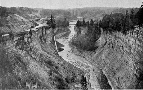 This week’s hike will follow trail #7 in Letchworth Park. Trail #7 is the portion of the Genesee Valley Greenway through the park. It is also the section of the Greenway with the most impressive relics of the Genesee Valley … Continue reading | ||||||
| Bristol Hills Branch 1:45 pm Bristol Hills Branch @ Bassett Hill Apr 15 @ 1:45 pm – 3:45 pm 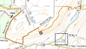 We are returning to our monthly series on the Bristol Hills Branch (BHB) of the Finger Lakes Trail (FLT). This Sunday and in May, we will climb up out of Italy Valley and cross Hi Tor overlooking Canandaigua Lake. These … Continue reading | Earth Dance 11:00 am Earth Dance @ Little Lakes Community Center Apr 21 @ 11:00 am – 5:00 pm Please join us on Saturday at the Earth Dance sponsored by and held at the Little Lakes Community Center in Hemlock. The community center is housed in the former Hemlock School across from the fair grounds. There are activities all … Continue reading | |||||
| Earth Day Road Side Clean Up 2:00 pm Earth Day Road Side Clean Up @ Firehall Apr 22 @ 2:00 pm – 4:00 pm Springwater Trails is taking part in the Livingston County “Operation Community Cleanup” in honor of Earth Day 2018. Join us at the Springwater Firehall at 2:00 on Sunday. After a brief safety reminder and cleanup instructions, we will break into groups … Continue reading | FLTC 2018 Spring Wally Wood Hike 9:30 am FLTC 2018 Spring Wally Wood Hike @ Parking area on Rt. 13/34/96 Apr 28 @ 9:30 am – 2:00 pm  We will be hiking from Stevenson Forest Preserve to and thru Robert H. Treman State Park. Distance 8.8 miles (there will be no shorter hike offered). We start the hike along the Stevenson Forest Preserve for about .5 mile and then … Continue reading | |||||
| Ontario Pathways Trail in Flint, NY 2:00 pm Ontario Pathways Trail in Flint, NY @ Parking Area Apr 29 @ 2:00 pm – 4:00 pm This hike will be an out-and-back walk along a section of the Ontario Pathways – a disused railway bed now open to all leisure activities. Starting in the hamlet of Flint, Springwater Trails hikers will walk north for a few … Continue reading |
This hike will be an out-and-back walk along a section of the Ontario Pathways – a disused railway bed now open to all leisure activities.
Starting in the hamlet of Flint, Springwater Trails hikers will walk north for a few miles along this former railroad bed. Because it is a linear trail and not a loop, we will return along the same path. There will be two groups this week – the Streakers and the Strollers.
Because the trail runs over a disused rail bed, it is pretty level. If the weather is suitable then it’s an easy trail for bicycles; there’s the occasional patch of gravel to pedal hard through, but mostly it’s a good surface.
Directions – The meeting point is a trail parking lot at GPS coordinates 42.860068, -77.111470 .
From the south, follow NYS Rt. 21 North from Naples (or wherever) to Canandaigua and then turn east on Rts. 5&20. In about 10 miles you will approach Flint and turn left (north) on County Road 20. You will see the parking lot immediately on your right that is for Ontario Pathways. Beyond that driveway is the Wayne Finger Lakes BOCES – don’t go there.
From the north come down Rt. 88 from Newark, turn right at Phelps and proceed west on Rt. 96, then turn left on Rt. 488 and proceed to the hamlet of Orleans. Just after the bend at Orleans, turn south on CR#20 to proceed to that same parking lot on the left this time.
Social – There will be a social somewhere in the vicinity to be determined by who is open on Sunday. If possible, it will be at Sweet Sue’s which is a short distance to the east on Rts. 5&20.
2:00 p.m. (Climbers: plan to arrive at 1:30 to help with a car pool to the parking lot at the north end boat launch. Please see below).
Join us for a spring hike on the new section of Rob’s Trail which meanders from Route 15A south of Hemlock to the shores of Hemlock Lake. We will meet at the new parking lot for Rob’s Trail on the west side of 15A. It is suggested that you wear sturdy hiking boots, and use a pole because of slippery leaves on steep inclines. With the warm weather predicted for this week, many of the spring wildflowers should be blooming.
Climbers: will hike down to Hemlock Lake and connect to the trail leading to the north and terminus (4.8 miles) at the Hemlock Lake boat launch. This will necessitate leaving one or more cars at the parking lot before the hike. Tourists: you may hike down the trail to the shore line and return back up to the starting point (1.5 miles each way). The hike back up is fairly strenuous in some places. Naturalists: you may hike halfway down to the new bridge and back up from there.
The social following the hike will take place at Sammy’s Place, 8148 S Main Street in Springwater. To get to Sammy’s Place, head south on 15A through the Springwater Hamlet. Sammy’s is on the right across from the Fire Hall.
Directions to TNC Parking Area West Side of Route NY 15A: From Springwater: Take Rt 15A north. In 6.1 miles, the parking lot is on the left just after the north end of Old Bald Hill Rd South. From Hemlock: Take Rt 15A south. At 4.7 miles south of the 20A/15A intersection south of Hemlock, the parking lot is on the right.
The hike on May 13th 2018 with be at the Cumming Nature Center in Honoeye. It will be a repeat of the hike we did there in the winter, and again Shariee Edersheim, the Cumming Center resident naturalist, will be guiding us along the route and showing us how much has changed since the winter and what to look for now that the New York spring is in full swing.
We’ll meet at the Nature Center reception at the usual time of 2:00pm. The part of the hike with Shariee will be suitable for all levels of hiker. Shariee’s part will be for about an hour; each group can then walk the center trails as much as they feel up to.
This hike is on Mother’s Day. Feel free to bring your mothers and any other relatives – it will be a great treat for them!
Directions;
From Rochester and points North: Take 390 South to Routes 5 & 20. Proceed east to Rt 15A in Lima. Head South on Rt 15A to Route 20A in Hemlock. Head East on 20A to East Lake Road in Honeoye. Proceed South on East Lake Road to County Road 33 (there are signs pointing the way from the junction of East Lake Road and County Road 33) Turn East on County Road 33 then Southwest on Pinewood Hill Road. This becomes Gulick Road. After 4.7 miles Coming Nature Center entrance will be on the Right.
From Springwater: Go North on Rout 15A to Route 20A in Hemlock. Head East on Route 20A to East Lake Road in Honeoye. Proceed South on East Lake Road to County Road 33 (Signs point the way from the junction of East Lake Road and County Road 33) Turn East on County Road 33, then South East on Pinewood Hill Road. This becomes Gulick Road. After 4.7 miles the Cumming Nature Center entrance will be on the right.
From Wayland, Naples, and points South: Follow NY21 East from Wayland thru N.Cohocton to Naples (11.4 miles) Turn Left onto Clark Street (County Road 36) heading North (Next to Middletown Tavern)) Take Right on Gulick Road. Follow Gulick Road for 6.6 miles. The Nature Center entrance will be on the Left.
The Social;
The After Hike Social will be at the Neapolitan Pizza at 120 N Main St, Naples, NY 14512.
Turn right out of the Nature Center onto Gulick Road. After 7 miles Gulick ends at County Road 36. Turn left (that’s south, and going downhill) onto County Road 36 and continue down the hill to where it ends at Rt. 21. Turn left (north) on Rt. 21; the Neapolitan is in a lovely Victorian house on the left after the center of the village, just before Lyon Street and opposite the Trinity Methodist Church.The sign hangs from a post at the end of the front garden; it’s small for the purpose and easy to miss.
 This Sunday, Springwater Trails returns to the Bristol Hills Branch of the Finger Lakes Trail. We will hike from Brinks Rd through Hi Tor to Rt 245. The group has done many hikes on this portion of the trail, but never all of the way across Hi Tor. So join us for a new view of the many aspects of this wonderful wildlife area.
NOTE: The weather report calls for rain on Sunday, so dress appropriately. Dress in layers – a backpack to carry your rain-gear may be a good idea. If lightning is expected we may need to cancel, so check here Sunday morning.
The Bristol Hills Branch through High Tor (from Access 7 to Access 5) is 5.6 miles. To allow for the extra distance, Climbers will meet at the Access 5 parking area on NY-245 in Naples at 1:15. We will carpool up to Access 7 on Brink Hill Rd. From there, the trail (marked with orange blazes) follows the creek to the upper section of Parrish Gully. In 1.8 miles, we will cross a different creek and climb up to a DEC access road which is a part of the blue trail. Crossing the blue trail we will cross the blue trail a second time during a steady 400 foot climb over the next 1.2 miles. At the top we will see a pond on the left, and a half mile later the blue trail will join us from the left. Continuing straight on the combined orange and blue trail, we will all assure Char that is all down hill from this point. The blue trail will leave us to the right and we will continue on the orange trail down a series of switchbacks to the Naples Creek and then out to our awaiting cars.
The Tourists and Naturalists will meet at Access 7 on Brink Hill Rd at 2:00. Plan to come 15 minutes early if you want to drop of food for the social at Amy’s house. There will be directions at the access point. The Tourists will follow the orange trail for 1.8 miles to the blue trail on the grassy access road. We will then turn right and follow the access road along the edge of Parish Gully to the parking area on NY-245 near the intersection with Parish Hill Rd. Cars will be available to transport the tourists back up to the cars and the social.This hike is about 3 miles and mostly downhill.
The Naturalists will enter High Tor 0.2 mile south of access 7, on a DEC access road. This hike will be an out and back, allowing the Naturalists to adjust the length of the hike to meet the wishes of the hikers. The road continues straight though the first intersection. At the second intersection, the naturalists should turn right to come to the lean-to and enjoy a long view of Canandaigua Lake. From there, turn around and follow the same road back to the cars.
Following the hike, join us for a social at Amy’s. Please bring a dish to pass and your own beverage (or make a small $5 contribution to the social fund).
Directions:
Climbers: Plan to arrive at the NY-245 parking area before 1:15. We will load perishable food for the social into coolers and leave in a carpool to the top of Brink Hill Rd.
From Springwater: Take NY-15 south to Wayland. Turn left and follow NY-21N through N. Cohocton (turn left at the stop sign), and Naples (another left at the stop sign).. 1.5 miles past the stop sign, across from Bob & Ruths, turn right onto NY-245. Just past the Naples Creek, park in the long lot in front of the DEC chain link fence. Plan on 30 minutes from Springwater.
From Honeoye: Take W. Lake Rd (CR 36) south to Naples. Turn left on NY-21 for 1.2 miles. Turn right onto NY-245. Just past the Naples Creek (0.3 miles), park in the long lot in front of the DEC chain link fence. Plan on 30 minutes from Honeoye.
Carpool to Access 7: Head east on NY-245 for 1.4 miles. Turn right onto Parish Hill Rd (a dirt road). In 1.9 miles, at the first intersection, turn right to stay on Parish Hill Rd. Turn left at the next intersection onto Shay Rd.Turn right at the next intersection (Brink Hill Rd), At the next intersection, turn right to stay on Brink Hill Rd. The parking area is on the right in about a quarter mile.
Tourists and Naturalists: Plan to arrive at the Brink Rd parking area by 1:45 if you want to drop off food at Amy’s. We will have directions to the social at the trail head. We will start the hike at 2:00.
From Springwater: Take NY-15 south to Wayland. Turn left and follow NY-21N through N. Cohocton (turn left at the stop sign). At the next stop sign in Naples, turn right onto NY-53. In 1.1 miles, turn left onto Italy Valley Rd. In 2.1 miles, turn left onto Basset Rd. In 1.6 miles, turn left onto Brink Hill Rd. The parking area is on the left.
From Honeoye: Take W. Lake Rd (CR 36) south to Naples. Turn right onto NY-21S. Continue straight onto NY-53S. In 1.1 miles, turn left onto Italy Valley Rd. In 2.1 miles, turn left onto Basset Rd. In 1.6 miles, turn left onto Brink Hill Rd. The parking area is on the left.
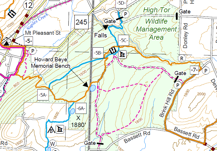
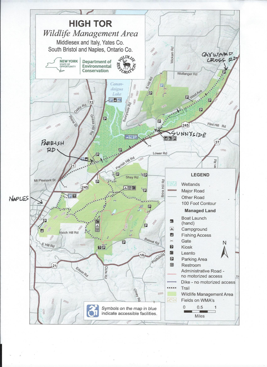 This Sunday we will hike the Middlesex Valley Rail Trail, which runs northeast from Naples, passing through the lowlands of the Hi Tor Wildlife Management Area. The 7.2 mile rail trail is parallel to and north of Route 245, and follows alongside of sections of the West River. We will hike the section between Parrish Road and Cayward Cross Road, placing cars at different parking areas along the way to allow for several distances of hiking. The trail is level and wide and slightly downhill, easy walking in grass, only partially mowed, and going through a few wet, muddy areas, so waterproof boots/long pants tucked into socks are recommended, along with insect spray and rain gear in case of showers. Also, please be alert for poison ivy on the trail, as there is quite a bit.
The Middlesex Valley Railroad began service in 1892 between Naples and Stanley, with connections to Geneva, Canandaigua and Wayne County. In 1895 it became part of the Lehigh Valley Railroad system, and continued running until 1970. Now part of the State-owned Hi Tor area, most of the trail is a raised path with wetlands on either side – some open and some forested. Along the way are wildflowers, waterfowl nesting boxes, and about a mile from the north end is a heron rookery. Hi Tor has been designated as an Important Bird Area by the Audubon Society, so we may see some interesting birds, and the frogs are likely to be croaking up a storm.
We will meet at 1:45 PM at the parking lot on the north side of Parrish Road, which runs across the valley from Route 21 (near Monica’s Pies) to Route 245 (near the base of Conklin Gully). We will leave enough cars at Parrish Road to accommodate the return trip for the Climbers. Tourists and Naturalists will proceed to the Sunnyside parking lot, from which the Tourists will hike south to Parish Road and back, a total of about 3.5 miles, all in the mowed section of the trail, with only minimal poison ivy along the way. Naturalists will hike from Sunnyside south to the DEC West River Boat Launch and back, a total of about 1 mile (farther if they are so inclined). The Climbers will drive to the north end of the trail, at Cayward Cross Road, and hike south, though the unmowed (but particularly scenic) section of the trail, past Sunnyside and on to Parrish Road, for a total distance of about 6 miles. Climbers are advised to wear heavy washable boots, as footwear will be exposed to some poison ivy in the northern section of the trail. Bring rubber gloves and plastic bags for use in safely removing boots, and clean footwear thoroughly with laundry detergent to avoid getting a poison ivy rash from your footwear. See https://rainyadventures.com/remove-poison-ivy-from-shoes/
Following the hike, please join us for an optional dish-to-pass social at the DEC West River Boat Launch, off of Route 245 about .5 mile south of the Sunnyside intersection. There is a porta-potty there, but no tables and chairs, so bring your own lawn chair and a card table or folding table if you have one. Alternative rain location for the social is the Naples Community Park, about 2.5 miles south of the Boat Launch on Route 45, just north of the DEC building, near the Village of Naples. The Park has a covered pavilion with picnic tables.
DIRECTIONS: From Springwater/Dansville/Wayland: Take Rt 21N into Naples. Turn left onto Main St for 1.5 miles. Turn right on Rt#245 (across from Bob and Ruth’s). Continue 1.5 miles, make a left on Parrish Rd., just after the intersection with Parrish Hill Road on the right. There is no street sign for Parrish Road, but there is a yellow house at the corner. Parking area is on the right, in about 0.2 miles.
From Honeoye: Take Rte.#36 south into Naples, left on Main St for approximately 1.25 miles. Right on Rte. #245 (Across from Bob and Ruth’s). Continue 1.5 miles then left on Parrish Rd., just after the intersection with Parrish Hill Road on the right. There is no street sign for Parrish Road, but there is a yellow house at the corner. Parking area is on the right, in about 0.2 miles.
From Canandaigua: Take Rt#21S to Woodville. Keep straight toward Naples. Turn left on Parrish Road about 1.5 miles past Woodville, just after you pass Monica’s Pies. The parking area will be on your left, in about 0.4 miles.
Annually, one of two big shindigs that Victor Hiking Trails (VHT) sponsors, is National Trails Day (NTD) observed each year on the first Saturday of June. In 2018 the date is June 2nd. VHT is of course one of many hiking groups that plans some organized observance on NTD. Yep, that word “national” does in fact imply many groups across the USA observe or celebrate NTD in some manner. Now, before I describe more about NTD activities that VHT hosts, you were wondering what the other big shindig that VHT has annually. Weren’t You? Answer: the second big shindig VHT does is the VHT “challenge hike” usually held sometime around late September.
NTD in Victor with VHT is usually three serial hikes, with a break in between each of the three hikes for rest and refreshment. The first hike is a morning hike and the last hike finishes in the afternoon.
Details for 2018 are: On Saturday, June 2nd, Victor Hiking Trails will host the 26th annual National Trails Day in Victor. Come to Finger Lakes Community College, Victor Campus, located at 200 Victor Heights Parkway, Victor, NY 14564, at 8:30 a.m. for a free continental breakfast. There will be three easy hikes beginning at 9:00 A.M., bottled water and snacks, a free pizza lunch with drinks and raffle prizes. Everyone who completes all three hikes will receive a free one-year membership to Victor Hiking Trails.
You can also read about National Trails Day 2018 in the the VHT newsletter The Pathfinder Spring 2018 edition (volume 23, issue 1, pages 2 & 7). A direct hyperlink to a VHT webpage about NTD 2018 is here. And of course, you can check the VHT website for updated details about VHT’s NTD hike for June 2nd, 2018.
This is a joint trip with the Rochester Mycological Assn & NYFA. We will explore Keshequa Creek with its cliffs and see beautiful large trees. Bring
lunch. Leader: Ed Fuchs, 598-1307, edfuchs.nfbs@gmail.com Call or e-mail Ed for meeting place and time.
SPRINGWATER TRAILS HIKE FOR 4:00 pm, June 3, 2018
LOCATION: Harriet Hollister Spencer State Park
HIKE DESCRIPTION: HIKERS WILL SPLIT INTO 3 GROUPS. Each group will walk at their own
pace. We will start at the main parking lot at the entrance to the park.
Naturalists have a couple of choices; walk the roadway into the park and enjoy the
spectacular view of Honeoye lake and continue into the picnic area. There are a few shorter
loop trails around the picnic area that can be walked , i.e. Raccoon Run, Whiteface and Blue Spruce.
Tourists have several options they can walk the roadway into the park,take the bicycle trail
Take Ruthie’s trail or any of the other trails in the park.
Climbers may wish to head out to the south end of the park on C4 snowmobile trail and walk
the field back out to Townline road where the can be picked up and shuttled back to the parking lot.
RECOMMENDATIONS: Bring water,bug juice,hat and preferably,light weight pants.
After hike social: We will have our social at the picnic area at Harriet Hollister Spencer. Hot dogs and hamburgers will be provided. Bring a dish to pass or a five dollar donation would be appreciated.
DIRECTIONS : From Rochester: Take RT 15A south.Two miles before Springwater village, turn
left onto Wheaton Hill Road. Drive for about 3 miles. Turn Left onto Wetmore Rd. and
straight thru onto Canadice Hill road and drive another 2 miles to The Park.
From Honeoye: take Cty Road 37 for 4-5 miles.Continue straight onto Canadice Hill Rd. at Cty
Rd 37 turnoff in Canadice Hamlet.follow Canadice Hill Rd for 3.4 miles until you reach the Park entrance.
The Finger Lakes Trail Conference Spring Weekend is a time when we bring members and guests from across the state together for a 3-day weekend of hikes and programs. It is also the time of the Annual Meeting of the FLTC Membership and Annual Awards Presentation.
Additional information will be posted on the FLTC Website.
The 21st Annual ADK-GVC Outdoor Expo will be held on Saturday, June 9th 2018 at the Beach area of Hundred Acre Pond in Mendon Ponds County Park off Douglas Road. Outdoor activities, learning, experiences, educational & workshop sessions, etc abound at this free event, 9:30AM-3:30PM. And, YES, there are free trials of various kayaks and/or canoes, this aquatic activity is at the beach area of the Hundred Acre Pond.
Myriad presentations and interactive events are mostly centered around the area near the beach and contiguous areas of the adjacent parking lot. Many organizations, individuals, and businesses, all come together with the Genesee Valley Chapter of the Adirondack Mountain Club (ADK-GVC) to make this a premier event for outdoor enthusiasts.
Here is a hyperlink to ADK Outdoor Expo. http://www.gvc-adk.org/expo
And here is a hyperlink to an article about the 2015 Outdoor Expo, included for reference of the myriad type activities.
Looking for brochure.or mailing list so I can receive it in the mail.
Nothing opens up for mailing list.
There’s all kinds of very bizarre ads and post for viagra and other drugs above on calender page.
Please let me know if there’s a brochure available