
Hikes led by Springwater Trails are generally held on Sunday afternoons and appear in this calendar in green.
| Sun | Mon | Tue | Wed | Thu | Fri | Sat |
|---|---|---|---|---|---|---|
| Finger Lakes Trail Conference Trail Maintenance Meeting 10:00 am Finger Lakes Trail Conference Trail Maintenance Meeting @ First Congregational Church Apr 7 @ 10:00 am – 2:00 pm | ||||||
| 7 Locks Hike 2:00 pm 7 Locks Hike @ Genesee Valley Greenway Apr 8 @ 2:00 pm – 4:00 pm 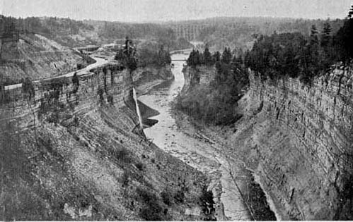 This week’s hike will follow trail #7 in Letchworth Park. Trail #7 is the portion of the Genesee Valley Greenway through the park. It is also the section of the Greenway with the most impressive relics of the Genesee Valley … Continue reading | ||||||
| Bristol Hills Branch 1:45 pm Bristol Hills Branch @ Bassett Hill Apr 15 @ 1:45 pm – 3:45 pm 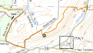 We are returning to our monthly series on the Bristol Hills Branch (BHB) of the Finger Lakes Trail (FLT). This Sunday and in May, we will climb up out of Italy Valley and cross Hi Tor overlooking Canandaigua Lake. These … Continue reading | Earth Dance 11:00 am Earth Dance @ Little Lakes Community Center Apr 21 @ 11:00 am – 5:00 pm Please join us on Saturday at the Earth Dance sponsored by and held at the Little Lakes Community Center in Hemlock. The community center is housed in the former Hemlock School across from the fair grounds. There are activities all … Continue reading | |||||
| Earth Day Road Side Clean Up 2:00 pm Earth Day Road Side Clean Up @ Firehall Apr 22 @ 2:00 pm – 4:00 pm Springwater Trails is taking part in the Livingston County “Operation Community Cleanup” in honor of Earth Day 2018. Join us at the Springwater Firehall at 2:00 on Sunday. After a brief safety reminder and cleanup instructions, we will break into groups … Continue reading | FLTC 2018 Spring Wally Wood Hike 9:30 am FLTC 2018 Spring Wally Wood Hike @ Parking area on Rt. 13/34/96 Apr 28 @ 9:30 am – 2:00 pm  We will be hiking from Stevenson Forest Preserve to and thru Robert H. Treman State Park. Distance 8.8 miles (there will be no shorter hike offered). We start the hike along the Stevenson Forest Preserve for about .5 mile and then … Continue reading | |||||
| Ontario Pathways Trail in Flint, NY 2:00 pm Ontario Pathways Trail in Flint, NY @ Parking Area Apr 29 @ 2:00 pm – 4:00 pm This hike will be an out-and-back walk along a section of the Ontario Pathways – a disused railway bed now open to all leisure activities. Starting in the hamlet of Flint, Springwater Trails hikers will walk north for a few … Continue reading |
This view of the Genesee River middle falls in Letchworth Park, shows the Genesee Valley Canal clinging to the steep wall of the gorge in the 1860s. Click on the image for more information from Letchworthparkhistory.com.
This week’s hike will follow trail #7 in Letchworth Park. Trail #7 is the portion of the Genesee Valley Greenway through the park. It is also the section of the Greenway with the most impressive relics of the Genesee Valley Canal.
Trail #7 starts at Oakland Rd about a mile outside of Nunda. Here we will walk next to the original locks that allowed boats to climb the hill to the River. The canal operated in this section between 1862 and 1878 and the right of way was sold to the Genesee valley Canal Railroad Company which built a railroad along much of the canal towpath. As we walk next to the canal lock, the railroad took another route slightly north. In about a half mile, the canal path rejoins the rail path up to Short Track Road. A short detour on Williams Road will take us into Letchworth Park proper, where we can pick up the rail bed again. After crossing a seasonal section of River Rd, the trail continues for another two miles to the Parade Grounds where, in warmer weather, we will return for a picnic.
All hikers will meet at the Parade Grounds in Letchworth Park, and will carpool to the start of the hike at Oakland Rd. The Tourists will drop off a car at River Rd on the way, to allow them to ferry back to their cars.
The Naturalists will start from Oakland Rd, following the canal to the junction with the railbed. It is just over a mile to Short Tract Road, where the Naturalists will turn around and hike back to the cars, using the railbed route all of the way, for a two mile hike.
The Tourists will follow the same route to Short Tract Rd. There is a slight jog to the right to follow a detour along Williams Rd. When the road turns left, continue straight into the woods on the Genesee Valley Greenway. The next road is River Rd, also known as Trail #8, where the Tourists will turn left and follow the road south to their cars on NY 436..This hike will be about 3 miles total.
 The Climbers will follow the Tourist route to River Rd, where it will continue on the Letchworth Branch of the FLT until we come to the Park Road. Turning left on the road will take us up to our cars at the Parade Ground parking area. Total hike: 4 miles.
Following the hike, we will gather at the Sunrise Restaurant in Dansville (188 Main St) for an optional social.
Directions Directions to the Parade Grounds inside Letchworth Park near the Portageville entrance.
From Springwater: Follow NY-15 South for 6.8 miles. Turn right onto I-390N. , take Ossian St (rt 36) west. In 6.2 miles, take the next exit (#4) for Dansville. Turn left onto NY-36 N and take the first left onto Jefferson St. At the end of Jefferson St, turn left on Ossian St.. Stay on Ossian St which becomes Rt 436. Continue on 436 for 18 miles to the Parade Grounds Entrance to Letchworth. Follow the Parade Grounds Road (a 90 degree right from Rt 436) into the park about 0.75 mile. We will meet in the parking area on the left side of the Parade Grounds Road. (N 42° 35.013 W 078° 01.910)

The entrance to Letchworth Park from Rt 436
From Dansville: From Main St, take Ossian St (rt 36) west. Stay on Ossian St which becomes Rt 436. Continue on 436 for 18 miles to the Parade Grounds Entrance to Letchworth. Follow the Parade Grounds Road (a 90 degree right from Rt 436) into the park about 0.75 mile. We will meet in the parking area on the left side of the Parade Grounds Road. (N 42° 35.013 W 078° 01.910)
From Mt Morris: Take Rt 408 S on Chapel St for 11.1 miles to Nunda. Turn Right on Rt 436 and proceed for 4.6 miles to the Parade Grounds Entrance to Letchworth. Follow the Parade Grounds Road (a 90 degree right from Rt 436) into the park about 0.75 mile. We will meet in the parking area on the left side of the Parade Grounds Road. (N 42° 35.013 W 078° 01.910)
Directions to the Sunrise Restaurant from Nunda: Take NY-436 East from Nunda. In Dansville, continue straight onto NY-36 Ossian St. At the light, turn left onto Main St. The restaurant is on the right side.
 We are returning to our monthly series on the Bristol Hills Branch (BHB) of the Finger Lakes Trail (FLT). This Sunday and in May, we will climb up out of Italy Valley and cross Hi Tor overlooking Canandaigua Lake. These two hikes are each over 5.5 miles, but don’t worry, we are planning hikes of various lengths so everyone is welcome to enjoy the trails.
This section of the BHB connects High Tor to Italy Hill State Forest with road walks and across private property. From the top of the hill, we will stop to enjoy a spectacular view of Italy Valley to the south.
 The Climbers will start on Italy Valley Road at 1010′ above sea level. We will cross a narrow field and then start climbing. All hikers will need to watch for the orange blazes and orange FLT discs to ensure we stay on the trail as it goes on and off a logging road. In just under a mile, we will climb 800 feet, to where the trail turns south and more closely follows the contours so we only climb another 200 feet over the next two miles. Just past the view clearing, we will turn north and exit the woods onto Wood Hill Rd. Following this seasonal road, we will return most of our altitude gain until we reach Bassett Rd and our waiting cars. If hikers want to continue on the road walk up Bassett Rd and Brink Hill Rd to Access Point 7 where next month’s hike will start, a car will meet them at
 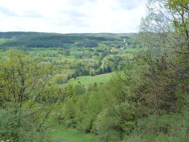 the end of the hike.
The Tourists will enjoy the same hike as the climbers but in reverse. This climb up Wood Hill Rd is only 700 feet over a mile. Once we leave Wood Hill Rd, the last 2.5 miles is all down hill. Bring a granola bar and enjoy a snack and a drink of water at the overlook at the top. The Climbers and Tourists will need to swap car keys when they pass each other.
 The Naturalists will hike the back side of High Tor, starting from the Bassett Rd parking area. This hike is on DEC maintenance roads which are wide and fairly flight (about 200 feet over a mile walk into the park. The Naturalists will follow the road to the left and continue for a mile until they reach the orange trail. A left turn onto the orange trail will bring the hikers to a pretty pond with the Howard Beye memorial bench to relax and enjoy the wildlife. From the pond, return on the orange trail back to the maintenance road. Turn right and continue down to the parking lot.
All hikers should meet at the Bassett Rd parking area in High Tor by 1:45 to give the tourists and climbers time to car pool to the starts of the hike. Tourists will go left on Bassett Rd and drive to Wood Hill Rd (the second left) and park on the shoulder of Bassett Rd. Climbers will continue on Bassett Rd past Wood Hill and turn left on Italy Valley Rd. In 3 miles, there are wooden horse fences on each side of the road. Just past the bridge across the creek, there is parking on the left at the trail head.Climbers will want to give their car keys to the Tourists when they meet them on the trail, so they can bring the cars back to Wood Hill Rd.
Following the hike, please join us for an optional social at the Redwood Inn in Naples. Follow Bassett Rd and Italy Valley Rd west to NY-53. Turn right toward Naples. At the hardware store, turn left onto NY-21 and the Redwood inn is on the left.
From Wayland: Head east on NY Route 21 toward N Cohocton and Naples. Turn left at the stop sign in N Cohocton to stay on Rt 21. At the stop sign in Naples, turn right onto NY 53. Follow Rt 53 for 1.3 miles, and turn left onto Italy Valley Rd (Co Rd 21). After 2.1 miles, turn left onto Bassett Rd. The parking area is on the left after the first curve (about 0.3 miles) up Bassett
From Naples: Take Main St (Rt 21) South through the town of Naples. Continue of Rt 53 when Rt 21 turns right. Follow Rt 53 for 1.3 miles, and turn left onto Italy Valley Rd (Co Rd 21). After 2.1 miles, turn left onto Basset Rd. The parking area is on the left about 0.3 miles up Basset.
Please join us on Saturday at the Earth Dance sponsored by and held at the Little Lakes Community Center in Hemlock. The community center is housed in the former Hemlock School across from the fair grounds.
There are activities all afternoon including:
|
Speakers |
||
| 11:30 | “What is Sustainable Beef?” | Fred Forsburg raises 100% grass-fed and finished cattle on organic pastures. |
| 12:00 | “Educating for Good Stewardship: The Gap Year Experience with Lagom Landing,” | Laurel Nelson and Roc Castor. |
| 1:00 | “Permaculture: Earth Care, People Care, and Resource Care,” | Patty Love from Barefoot Permaculture. |
| 2:00 | “Solar and Geothermal Installation Basics,” | Zack Parker from ACES Energy. |
| 3:00 | “Local Medicinal Plants and Community Herbalism,” | Sherry Gendreau. |
| 4:00 | “Hiking Opportunities in the Little Finger Lakes Area,” | Mark Hopkins, Melissa Cohen. |
|
Children’s Activities |
||
| 12:00 | “Raptor Connections, featuring Live Birds of Prey” | Deana Ford, President, Braddock Bay Raptor Research, |
| 1:00 | “Reading with Rabbits,” | Dorothea Prine, Story Book Cottage Rabbitry. |
| 2:00 | “Seeker’s Circle: Interactive Native Entertainment for Children,” | Stan Kawasczynski, Native American Faith Keeper and Story Teller for the Seneca Nation. |
| 3:00 | “Kid Fit Exercise,” | Shanna Butler Fitness and Dance (children 5 years and up.) |
|
Yoga |
||
| 11:00 | “Introduction to Yoga,” | Audrey Harpe of Yoga Bhoga |
| 2:00 | “Yoga for Gardeners,” | Audrey Harpe of Yoga Bhoga |
Springwater Trails is taking part in the Livingston County “Operation Community Cleanup” in honor of Earth Day 2018. Join us at the Springwater Firehall at 2:00 on Sunday. After a brief safety reminder and cleanup instructions, we will break into groups to remove trash and litter that has gathered along seven miles of highway.
All members of the greater Springwater Community are welcome to join this effort.
Directions:
From Springwater: The Fire Hall is 0.6 miles south of the intersection of NY 15 and NY 15A in Springwater, on the left (East) side of route NY 15.
From Wayland: Head north on NY 15 for 4.5 miles. The Fire Hall is on the right.
From Hemlock: Head south on NY 15A for 11 miles. At the flashing light, continue straight onto NY 15 for 0.6 miles. The Fire Hall is on the left.
We will be hiking from Stevenson Forest Preserve to and thru Robert H. Treman State Park. Distance 8.8 miles (there will be no shorter hike offered). We start the hike along the Stevenson Forest Preserve for about .5 mile and then have an early road walk with an uphill on Porter Hill Road. Overall, we will be going on a descending plane on the hike. Poles are recommended. On the way, we will have an option of going thru the Bock-Harvey Preserve and will pass nearby the Pinecreek Campground. We will enter the State Park at Woodard Road. The trail parallels the Enfield Creek. Please come out and join your fellow hikers to get those legs moving on our spring hike in honor of Wally Wood.
Please check for updates on the FLTC Website.
HIKE LEADERS
Theresa and Jay Evans
MEETING TIME
9:30 a.m. Please try to be there and ready to go at this time
MEETING LOCATION
Parking area on Rt. 13/34/96—918-998 W. Danby Rd., Ithaca, NY 14850 – coordinates 42.3982,-76.5426 or N 42.23.8934 W76 32.7699, which is outside of Robert H. Treman State Park (Eastern End) .
DIRECTIONS TO MEETING LOCATION
From Rt. 81 N/S take Exit 12onto Rt 281 to Rt. 13, continuing on thru Dryden, then to Ithaca, NY, Continue on Rt. 13 past entrance to Robert Treman State Park. You then bear to left lane onto Rts. 34/96 and left again (circle around), parking area is the 2nd right (comes up quickly) – Google the FLT interactive map if not familiar with this area.
(NOTE: there will be a car pool shuttle (about 10 minutes) to the start of the hike at Stevenson Forest Preserve (on Trumble Corners Road).
This hike will be an out-and-back walk along a section of the Ontario Pathways – a disused railway bed now open to all leisure activities.
Starting in the hamlet of Flint, Springwater Trails hikers will walk north for a few miles along this former railroad bed. Because it is a linear trail and not a loop, we will return along the same path. There will be two groups this week – the Streakers and the Strollers.
Because the trail runs over a disused rail bed, it is pretty level. If the weather is suitable then it’s an easy trail for bicycles; there’s the occasional patch of gravel to pedal hard through, but mostly it’s a good surface.
Directions – The meeting point is a trail parking lot at GPS coordinates 42.860068, -77.111470 .
From the south, follow NYS Rt. 21 North from Naples (or wherever) to Canandaigua and then turn east on Rts. 5&20. In about 10 miles you will approach Flint and turn left (north) on County Road 20. You will see the parking lot immediately on your right that is for Ontario Pathways. Beyond that driveway is the Wayne Finger Lakes BOCES – don’t go there.
From the north come down Rt. 88 from Newark, turn right at Phelps and proceed west on Rt. 96, then turn left on Rt. 488 and proceed to the hamlet of Orleans. Just after the bend at Orleans, turn south on CR#20 to proceed to that same parking lot on the left this time.
Social – There will be a social somewhere in the vicinity to be determined by who is open on Sunday. If possible, it will be at Sweet Sue’s which is a short distance to the east on Rts. 5&20.
2:00 p.m. (Climbers: plan to arrive at 1:30 to help with a car pool to the parking lot at the north end boat launch. Please see below).
Join us for a spring hike on the new section of Rob’s Trail which meanders from Route 15A south of Hemlock to the shores of Hemlock Lake. We will meet at the new parking lot for Rob’s Trail on the west side of 15A. It is suggested that you wear sturdy hiking boots, and use a pole because of slippery leaves on steep inclines. With the warm weather predicted for this week, many of the spring wildflowers should be blooming.
Climbers: will hike down to Hemlock Lake and connect to the trail leading to the north and terminus (4.8 miles) at the Hemlock Lake boat launch. This will necessitate leaving one or more cars at the parking lot before the hike. Tourists: you may hike down the trail to the shore line and return back up to the starting point (1.5 miles each way). The hike back up is fairly strenuous in some places. Naturalists: you may hike halfway down to the new bridge and back up from there.
The social following the hike will take place at Sammy’s Place, 8148 S Main Street in Springwater. To get to Sammy’s Place, head south on 15A through the Springwater Hamlet. Sammy’s is on the right across from the Fire Hall.
Directions to TNC Parking Area West Side of Route NY 15A: From Springwater: Take Rt 15A north. In 6.1 miles, the parking lot is on the left just after the north end of Old Bald Hill Rd South. From Hemlock: Take Rt 15A south. At 4.7 miles south of the 20A/15A intersection south of Hemlock, the parking lot is on the right.
The hike on May 13th 2018 with be at the Cumming Nature Center in Honoeye. It will be a repeat of the hike we did there in the winter, and again Shariee Edersheim, the Cumming Center resident naturalist, will be guiding us along the route and showing us how much has changed since the winter and what to look for now that the New York spring is in full swing.
We’ll meet at the Nature Center reception at the usual time of 2:00pm. The part of the hike with Shariee will be suitable for all levels of hiker. Shariee’s part will be for about an hour; each group can then walk the center trails as much as they feel up to.
This hike is on Mother’s Day. Feel free to bring your mothers and any other relatives – it will be a great treat for them!
Directions;
From Rochester and points North: Take 390 South to Routes 5 & 20. Proceed east to Rt 15A in Lima. Head South on Rt 15A to Route 20A in Hemlock. Head East on 20A to East Lake Road in Honeoye. Proceed South on East Lake Road to County Road 33 (there are signs pointing the way from the junction of East Lake Road and County Road 33) Turn East on County Road 33 then Southwest on Pinewood Hill Road. This becomes Gulick Road. After 4.7 miles Coming Nature Center entrance will be on the Right.
From Springwater: Go North on Rout 15A to Route 20A in Hemlock. Head East on Route 20A to East Lake Road in Honeoye. Proceed South on East Lake Road to County Road 33 (Signs point the way from the junction of East Lake Road and County Road 33) Turn East on County Road 33, then South East on Pinewood Hill Road. This becomes Gulick Road. After 4.7 miles the Cumming Nature Center entrance will be on the right.
From Wayland, Naples, and points South: Follow NY21 East from Wayland thru N.Cohocton to Naples (11.4 miles) Turn Left onto Clark Street (County Road 36) heading North (Next to Middletown Tavern)) Take Right on Gulick Road. Follow Gulick Road for 6.6 miles. The Nature Center entrance will be on the Left.
The Social;
The After Hike Social will be at the Neapolitan Pizza at 120 N Main St, Naples, NY 14512.
Turn right out of the Nature Center onto Gulick Road. After 7 miles Gulick ends at County Road 36. Turn left (that’s south, and going downhill) onto County Road 36 and continue down the hill to where it ends at Rt. 21. Turn left (north) on Rt. 21; the Neapolitan is in a lovely Victorian house on the left after the center of the village, just before Lyon Street and opposite the Trinity Methodist Church.The sign hangs from a post at the end of the front garden; it’s small for the purpose and easy to miss.
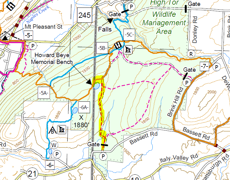
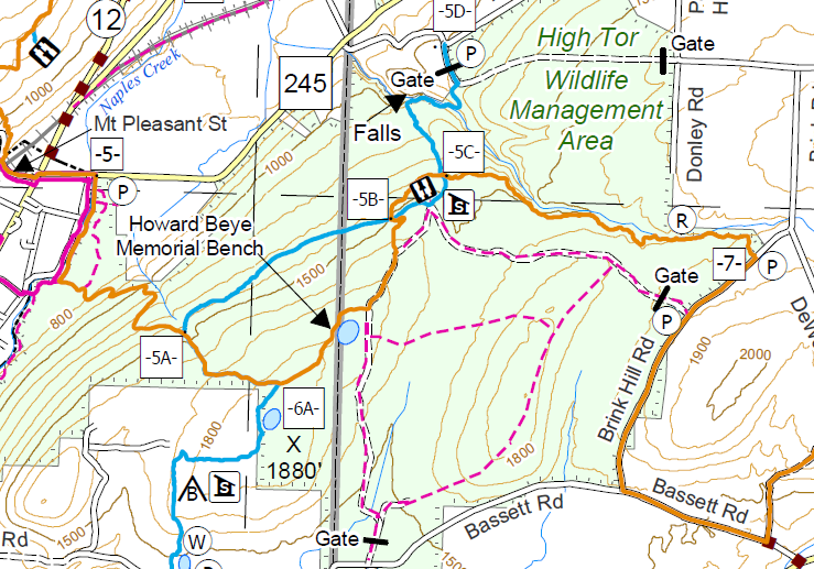 This Sunday, Springwater Trails returns to the Bristol Hills Branch of the Finger Lakes Trail. We will hike from Brinks Rd through Hi Tor to Rt 245. The group has done many hikes on this portion of the trail, but never all of the way across Hi Tor. So join us for a new view of the many aspects of this wonderful wildlife area.
NOTE: The weather report calls for rain on Sunday, so dress appropriately. Dress in layers – a backpack to carry your rain-gear may be a good idea. If lightning is expected we may need to cancel, so check here Sunday morning.
The Bristol Hills Branch through High Tor (from Access 7 to Access 5) is 5.6 miles. To allow for the extra distance, Climbers will meet at the Access 5 parking area on NY-245 in Naples at 1:15. We will carpool up to Access 7 on Brink Hill Rd. From there, the trail (marked with orange blazes) follows the creek to the upper section of Parrish Gully. In 1.8 miles, we will cross a different creek and climb up to a DEC access road which is a part of the blue trail. Crossing the blue trail we will cross the blue trail a second time during a steady 400 foot climb over the next 1.2 miles. At the top we will see a pond on the left, and a half mile later the blue trail will join us from the left. Continuing straight on the combined orange and blue trail, we will all assure Char that is all down hill from this point. The blue trail will leave us to the right and we will continue on the orange trail down a series of switchbacks to the Naples Creek and then out to our awaiting cars.
The Tourists and Naturalists will meet at Access 7 on Brink Hill Rd at 2:00. Plan to come 15 minutes early if you want to drop of food for the social at Amy’s house. There will be directions at the access point. The Tourists will follow the orange trail for 1.8 miles to the blue trail on the grassy access road. We will then turn right and follow the access road along the edge of Parish Gully to the parking area on NY-245 near the intersection with Parish Hill Rd. Cars will be available to transport the tourists back up to the cars and the social.This hike is about 3 miles and mostly downhill.
The Naturalists will enter High Tor 0.2 mile south of access 7, on a DEC access road. This hike will be an out and back, allowing the Naturalists to adjust the length of the hike to meet the wishes of the hikers. The road continues straight though the first intersection. At the second intersection, the naturalists should turn right to come to the lean-to and enjoy a long view of Canandaigua Lake. From there, turn around and follow the same road back to the cars.
Following the hike, join us for a social at Amy’s. Please bring a dish to pass and your own beverage (or make a small $5 contribution to the social fund).
Directions:
Climbers: Plan to arrive at the NY-245 parking area before 1:15. We will load perishable food for the social into coolers and leave in a carpool to the top of Brink Hill Rd.
From Springwater: Take NY-15 south to Wayland. Turn left and follow NY-21N through N. Cohocton (turn left at the stop sign), and Naples (another left at the stop sign).. 1.5 miles past the stop sign, across from Bob & Ruths, turn right onto NY-245. Just past the Naples Creek, park in the long lot in front of the DEC chain link fence. Plan on 30 minutes from Springwater.
From Honeoye: Take W. Lake Rd (CR 36) south to Naples. Turn left on NY-21 for 1.2 miles. Turn right onto NY-245. Just past the Naples Creek (0.3 miles), park in the long lot in front of the DEC chain link fence. Plan on 30 minutes from Honeoye.
Carpool to Access 7: Head east on NY-245 for 1.4 miles. Turn right onto Parish Hill Rd (a dirt road). In 1.9 miles, at the first intersection, turn right to stay on Parish Hill Rd. Turn left at the next intersection onto Shay Rd.Turn right at the next intersection (Brink Hill Rd), At the next intersection, turn right to stay on Brink Hill Rd. The parking area is on the right in about a quarter mile.
Tourists and Naturalists: Plan to arrive at the Brink Rd parking area by 1:45 if you want to drop off food at Amy’s. We will have directions to the social at the trail head. We will start the hike at 2:00.
From Springwater: Take NY-15 south to Wayland. Turn left and follow NY-21N through N. Cohocton (turn left at the stop sign). At the next stop sign in Naples, turn right onto NY-53. In 1.1 miles, turn left onto Italy Valley Rd. In 2.1 miles, turn left onto Basset Rd. In 1.6 miles, turn left onto Brink Hill Rd. The parking area is on the left.
From Honeoye: Take W. Lake Rd (CR 36) south to Naples. Turn right onto NY-21S. Continue straight onto NY-53S. In 1.1 miles, turn left onto Italy Valley Rd. In 2.1 miles, turn left onto Basset Rd. In 1.6 miles, turn left onto Brink Hill Rd. The parking area is on the left.
Looking for brochure.or mailing list so I can receive it in the mail.
Nothing opens up for mailing list.
There’s all kinds of very bizarre ads and post for viagra and other drugs above on calender page.
Please let me know if there’s a brochure available