Hikes led by Springwater Trails are generally held on Sunday afternoons and appear in this calendar in green.
- Categories
- Tags Barry Childs and Kathy Cloonan barry@africabridge Bike Bill Cooke Bob Menz (bert6952@yahoo.com) Bristol Hills Branch CANCELED Clarks Gully CLWA Colorado Trail Dog friendly Finger Lakes Trail FL FLT Gene & Georgia Binder (585) 236-5384 Gene and Georgia Binder (585) 236-5384 Greenway Gully Gypsy moth Hemlock Hike John L Katherine Humphrey? Kayak Landowner Liability Leader: Mark Lehigh Valley Trail Mark and Laure Allen (585) 662-9305 Mark and Linda Mary Ann Devey (315) 573-0774 Mary Lou Wenthe (585) 208-4337 Melissa Mitchellsville mjkcloonan@frontiernet.net Mushroom Foray Naples Nunda POSTPONED Saralinda Saralinda Hooker Schribner Scott Sevensma (585) 413-8461 Sharon Boldt (boldtbs@yahoo.com) sugarbush hollow Summer Weekly Wendy Stevenson
| Sun | Mon | Tue | Wed | Thu | Fri | Sat |
|---|---|---|---|---|---|---|
| SWCHS Annual Pulled Pork Dinner 12:00 pm SWCHS Annual Pulled Pork Dinner @ Springwater/Webster Crossing Historical Museum Sep 3 @ 12:00 pm As a tradition started several years ago, the Springwater / Webster Crossing historical Society is serving Pulled Pork prepared by Ted Canute and Scott Standish. The $10 Dinner includes Salt Potatoes, Vegetable in Season, dish-to-pass Dessert, and Pink Lemonade. Cookies … Continue reading → All Western Evergreen Tree Farm Annual Mushroom Hunt & ID 2:00 pm All Western Evergreen Tree Farm Annual Mushroom Hunt & ID Sep 3 @ 2:00 pm – 4:00 pm  Welcome to the Fourth Annual Mushroom Foray at the All Western Evergreen Farm. Three hiking groups are planned, all starting and ending at the farm house. We will explore much of the farm, enjoying views of the valley and close-ups of the … Continue reading → | Genesee Valley Greenway Passport Series – 2017 – hike #6 (modified) – Fowlerville Rd southbound 10:00 am Genesee Valley Greenway Passport Series – 2017 – hike #6 (modified) – Fowlerville Rd southbound @ Genesee Valley Greenway - Fowlerville Rd Sep 9 @ 10:00 am – 12:00 pm Genesee Valley Greenway (GVG) hike on Saturday, 9/9/2017. Series Hike #6 (modified)—Fowlerville Road going south. Historic Interpretive Hike Series (Wegmans Hike #6, please note this hike is modified): Fowlerville Rd going south Saturday, September 9th, 2017 10:00 AM GVG Parking … Continue reading → | |||||
| Hike Rob’s Trail & Paddle Hemlock Lake 2:00 pm Hike Rob’s Trail & Paddle Hemlock Lake Sep 10 @ 2:00 pm – 4:00 pm 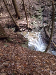 This Sunday Springwater Trails will be hosting a hike and kayak event at the Hemlock Lake north boat launch. Rather than our normal three hikes, you will be able to choose whether to Hike, Kayak, or do a mix hike/kayak. … Continue reading → | Mid-week Vermont hiking outing 4:00 pm Mid-week Vermont hiking outing Sep 12 @ 4:00 pm – Sep 14 @ 1:00 pm Come to the Green Mountains! Join Pam and Bill for 3 days of midweek hiking centered in the Killington area, home of Vermont’s second-highest mountain at 4,235′. Dates are Tuesday-Thursday, September 12-14. As explained in the details below, we request … Continue reading → | |||||
| Huckleberry Bog – BHB Hike#3 2:00 pm Huckleberry Bog – BHB Hike#3 Sep 17 @ 2:00 pm – 4:00 pm 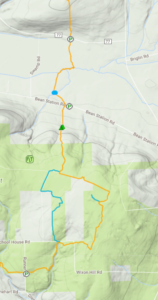 Linda and I did a pre-hike on Saturday, 9/16/2017, and we have some updated details, which are shown in purple below. The September Bristol Hills Branch hike will feature a return to Huckleberry Bog in the Urbana State Forest. For hikers … Continue reading → | ||||||
| Open House at Parsons’ Workshop 1:00 pm Open House at Parsons’ Workshop @ Parsons Pipe Organ Builders Shop Sep 24 @ 1:00 pm – 4:00 pm All are welcome to view and play the Aeolian home organ recently restored for a private residence. Originally installed in 1928, this organ is equipped with a player mechanism that enables the instrument to play from a repertoire of over … Continue reading → Stid Hill 2:00 pm Stid Hill Sep 24 @ 2:00 pm – 4:00 pm 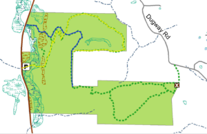 As the forecast for this Sunday is calling for temps to approach 90, the one saving grace will be that we will be in the woods… Stid Hill WMA is a DEC managed property consisting of two tracts in Bristol … Continue reading → |
-
Categories
-
Tags
Barry Childs and Kathy Cloonan barry@africabridge Bike Bill Cooke Bob Menz (bert6952@yahoo.com) Bristol Hills Branch CANCELED Clarks Gully CLWA Colorado Trail Dog friendly Finger Lakes Trail FL FLT Gene & Georgia Binder (585) 236-5384 Gene and Georgia Binder (585) 236-5384 Greenway Gully Gypsy moth Hemlock Hike John L Katherine Humphrey? Kayak Landowner Liability Leader: Mark Lehigh Valley Trail Mark and Laure Allen (585) 662-9305 Mark and Linda Mary Ann Devey (315) 573-0774 Mary Lou Wenthe (585) 208-4337 Melissa Mitchellsville mjkcloonan@frontiernet.net Mushroom Foray Naples Nunda POSTPONED Saralinda Saralinda Hooker Schribner Scott Sevensma (585) 413-8461 Sharon Boldt (boldtbs@yahoo.com) sugarbush hollow Summer Weekly Wendy Stevenson
 Linda and I did a pre-hike on Saturday, 9/16/2017, and we have some updated details, which are shown in purple below.
The September Bristol Hills Branch hike will feature a return to Huckleberry Bog in the Urbana State Forest. For hikers who joined Wendy on the hike last November, each route will have enough differences to keep you interested.
The hike will pass an old cemetery (see below) where we will have a more informal “bring your own sandwich” social following the hike. We will not try to carry the Picnic Tote up to the social, so bring hand food and a drink. A blanket or chair to sit on might also be good.
We will all meet at Access 15 on CR 77, Shuart Rd, just past the “Welcome to Pulteney” sign. Climbers and Naturalists will leave their cars on the shoulder parking area just west of the trail entrance. Others should temporarily park on the shoulder past the entrance.
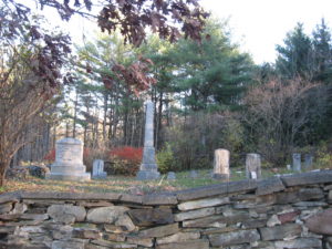 Climbers will head south on the Orange blazed trail for a total of 4 miles and a climb of 600 ft. The trail crosses Bean Station Rd and passes a restored cemetery and a shelter available to hikers wishing to camp. At the first register, take time to look at the interpretive nature guide books, the work of Irene Szabo and Wayland-Cohocton High School science class and their teacher, Robert Hughes. Climbers should stay on the orange trail around the bog. The blue trail to the left will rejoin in 1.6 miles. At the next register, stay left to the Access 17 and the Tourists cars. Hopefully, we will have met the tourists and borrowed a couple of keys to return their cars down to Bean Station Rd
 The Tourists will carpool to the end of their hike at Access 16 on Bean Station Rd, leaving as many cars as possible there. They will then drive enough cars to carry all of the Tourists, and also to carry all of the Climbers back, up to Access 17. There is parking for 3 cars off road. The rest will need to park on the side of the road. In about half a mile there is a registry and the trail goes left and right to start the loop around the bog. You better sign in and note that the climbers are coming the other direction and will sign in at the north register. Stay on the main orange BHB trail to the right. The blue trail is half a mile shorter. The two sides of the loop join at a second register and the main orange trail turns right (north). Its all down hill from here, so watch your step if the ground is wet. When you get to the Evangeline Shelter on the right, the cars at Bean Station Road are 2/10ths of a mile ahead.
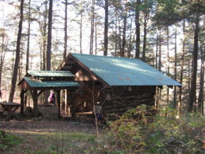 The Naturalists will start the same direction as the Climbers, though at a more relaxed pace. After crossing a small bridge in the middle of a field, the trail will slowly climb about 70 ft to Bean Station Rd. The naturalists, now have the option to continue across Bean Station Rd to the Cemetery and the Shelter. The Naturalists may then hike back to to cars on Shuart Rd for a round trip hike of 2.2 miles, or can use a Tourists car to return to the cars (Please arrange at the start of the hike to keep a spare set of keys with one of the tourist drivers).
Directions:
From Springwater: Take Rt 15 South to Wayland. At the stop light, turn left and follow Rt 21 through North Cohocton (take a left at the stop sign) to the south end of Naples. At the stop sign, turn right onto NY 53S for 12.1 miles. Turn left onto Waldo Rd. Continue straight onto CR 77 (Shuart Rd). In 2.3 miles, parking is on the right hand shoulder just past the “Pulteney” sign. Tourists should temporarily park east of the trailhead.
From Naples and points north: Follow Rt 21S through Naples. Continue straight onto NY 53S. Continue for 12.1 miles. Turn left onto Waldo Rd. Continue straight onto CR 77 (Shuart Rd). In 2.3 miles, parking is on the right hand shoulder just past the “Pulteney” sign. Tourists should temporarily park east of the trailhead.
Directions for Tourists to parking areas:
From CR77 to Bean Station Rd: Continue east on CR77. Take the first right to stay on CR77. Continue straight on Depew Rd when CR77 turns left. Take the first right on Bean Station Rd. The trail crosses the road. Park on the side of the road opposite the trail bridge Leave some cars here for the end of the hike.
To Glenbrook or Runner Rd: Continue west on Bean Station Rd for about 1.5 miles. Turn left onto Colegrove Hill Rd. Follow Colegrove Hill Rd for 2 miles. At the 4 way intersection, turn left on Dinehart Rd. Take the first left onto Glenbrook Rd (aka Runner Rd). There is a small parking area on the right side in about 0.2 miles.
Back to CR77 from Runner Rd: Head down hill (south) from the parking area on Runner Rd. Turn right on Dinehart, and right again onto 2 Rod Road (or Colegrove Hill Rd).Continue to the end of the road. Turn left onto Bean Station Rd. In 1 mile, turn right on Muck Rd. Turn right on CR77 (Shuart Rd). The cars will be on the right in 1.7 miles. Follow the directions to Bean Station Rd above to get back to the cemetery.
All are welcome to view and play the Aeolian home organ recently restored for a private residence. Originally installed in 1928, this organ is equipped with a player mechanism that enables the instrument to play from a repertoire of over 800 musical compositions.
Unfortunately, this open house coincides with the Stid Hill hike, but interested hikers might be able to work in a half hour or so with careful planning. Their facility is about a mile north of the Stid Hill parking lot.
Even if you can’t make the open house, take a moment to view pictures of the restoration.
 As the forecast for this Sunday is calling for temps to approach 90, the one saving grace will be that we will be in the woods…
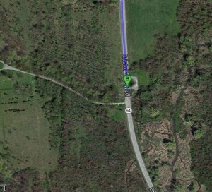
Stid Hill WMA is a DEC managed property consisting of two tracts in Bristol and South Bristol. We will meet at the northern parking area on NY-64 north of Bristol Mountain Ski Resort.
This week’s hike will vary somewhat from others we have done on Stid Hill – it will be free of the many downed trees that required ducking under/climbing over and, the ground is bone dry which means no slippery muck. There has also been quite a bit of mowing around the meadows which will make the Tourist and Naturalist hikes more enjoyable.
Three hikes will be offered: Climbers will hike along the switchbacks, created by the mountain bikers, for a leisurely stroll to the intersection of the YELLOW and BLUE trails. They will then bear right onto the BLUE trail heading uphill – a short but steep climb – and continue along on the BLUE trail until we reach the turnoff for the YELLOW trail that heads towards Dugway Road. We will take the YELLOW trail about halfway there, then follow a loop back to the BLUE trail and return to the parking lot.
Tourists will take the same switchback trail to the YELLOW and BLUE intersection and will bear left onto the BLUE trail, heading downhill to the meadow and following it back to the parking lot. If there is time, they can also do some creek walking in Mud Creek which has a very low water level now.
Naturalists will stay below, to explore the meadows and Mud Creek.
Our after-hike social will be at Brew and Brats, about 3 miles south of Stid Hill on Rte. 64. In addition to Brats, they also offer a variety of salads, craft beer and wine.
Directions
PLEASE NOTE: This weekend is the Naples Grape Festival. If you are coming from or going through Naples, allow extra time or take CR 36 (across from the Kwik Fill) north to Honeoye and follow the directions from there.
From Honeoye: Take US-20A East to Bristol Valley. Turn right on NY-64 S. Follow NY-64 for 4.8 miles. The parking area is on the left.
From Naples: Take NY-21 North to the intersection with NY-64 just before S. Bristol. Stay left onto NY-64. The parking area is 4.8 miles north on the right (1.4 miles past the ski area).
From Rochester: Take 490 East to the Victor Exit. Follow NY-96 into Victor. At the road sign for Bristol Mountain Ski Area, turn right on Maple Ave (NY-444) through Bloomfield (4 miles). Turn left on US-20 for 1.2 miles and right onto NY 64. The parking area is on the left 8.5 miles south of US-20.
From Springwater: Google recommends going north to Honeoye, saying that is 6 minutes faster than going south through Wayland and Naples. Take 15A north. Just before Hemlock, turn right on US-20A to Honeoye. Continue on US-20A East to Bristol Valley. Turn right on NY-64 S. Follow NY-64 for 4.8 miles. The parking area is on the left.
From Wayland: This weekend avoid Naples, so Take NY15 north to Springwater. Continue straight through the flashing light on NY-15A. Just before Hemlock, turn right on US-20A to Honeoye. Continue on US-20A East to Bristol Valley. Turn right on NY-64 S. Follow NY-64 for 4.8 miles. The parking area is on the left..
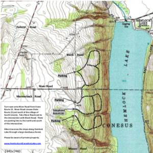 This Sunday we are returning to the upper trails on the west side of Hemlock Lake. There are several loops that have been mowed and we will take advantage of them to create Naturalists, Tourists and Climbers hikes. Following the hike, bring a dish to pass and we will have an optional social at the Eagle Crest Winery (wine tasting available for $3) two miles south of our meeting spot.
This is the first day of Bow-hunting, so please wear some bright orange so we can safely share the woods with the hunters.
The history of the Eagle Crest Winery reaches back to 1872 when Bishop McQuaid of Rochester established the O-Neh-Da Vineyard on the hills above Hemlock Lake. Today, the privately owned winery produces both O-Neh-Da and Eagle Crest wines. The Tasting Room is open from 11am to 5pm (tastings $3) and will be open following our hike.
We will meet at the first parking area coming from the north. The parking will be on the left (east) side, before you come to the intersection with Niver Rd. All hikes will start and end at this point.
The Naturalists will stay to the right on the first loop, then go right to cross over to the second loop. Turning left onto the second loop, the Naturalists will then stay on the upper part of the loop (turn right at the intersections) until they come back to the road. They can walk north back along the road, or go back into the woods at the first entrance and stay to the left to return to the cars.
The Climbers and Tourists will go to the left from the cars, go around to first double loop, then take the connector to the second loop. The Climbers will take the lower portion of this loop, while the Tourists will take the first right for the upper part of the loop. Based on time, when the hikers reach the road, they can turn left (south) to go down to the third loop and follow it around. Finally, return to the cars along the road.
When the hikes are complete, all hikers are invited to join us at Eagle Crest for an outdoor social under their tent. Bring a dish to pass, and your own beverage (or contribute to our social fund). The winery tasting room will be open until 5:00. Turn left out of the parking area and continue straight south for 1.8 miles. Go past the old Mission and take the next left on Vineyard Rd. The winery is about a quarter mile down the hill.
Directions:
 From Wayland and Springwater: take 15A N to the North end of Hemlock Lake. Go Left on Rix Hill Rd for 1.2 miles through the park. Take a sharp left on Blank Rd at the top of the hill. Continue south for 1.4 miles to the first DEC parking lot on the left. (If you come to Niver Rd, where Blank Rd becomes a dirt road, you have gone too far. Turn around and go back about 0.2 miles.)
From Websters Crossing: take 15N for 4.6 miles from May Rd, past Sliker Hill Rd. After the hamlet of Conesus, take a slight right onto Federal Rd (CR 56). In 2.9 miles, turn Right on Niver Rd. Follow Niver for 1.9 miles. At the end, turn left onto Blank Rd. The parking lot is on the right in 0.2 miles.
From Livonia: take 15S 4.2miles and turn Left on Niver Rd. At the end, turn left onto Blank Rd. The parking lot is on the right in 0.2 miles.
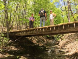 The NCS Honor Society has offered to do some maintenance and construction work on the BHB in Naples as part of their community service commitment. They will be working on the landscaping around the new bridge on Gideon Hanggi’s land. If you can spare a couple of hours on a Sunday afternoon in October to help Donna, our FLT volunteer coordinator, to support these teenagers, please meet at Bob and Ruth’s parking lot on Rt 21 in Naples at 12:30. We will work from 1 to 3. Please RSVP if you plan to come.
Genesee Valley Greenway State Park Passport Series – 2017 – hike #7 on 2nd Saturday of October
Historic Interpretive Hike Series (Wegmans Hike #7):
– – – Please check the online sources below for particulars of this hike. – – –
The guide will provide history of the Town of York and also point out historic canal and railroad features, and also note interesting natural features along the way. This hike is one of 14 hikes in the Wegmans Passport to Wellness Program. Completion of hikes in this series makes the trail user eligible for Wegmans grocery coupons or a NYS Parks Empire Passport. Passports will be available at the time of the hike and there will be an opportunity to complete the rubbing for this hike. Questions: fogvg@frontier.com or (585) 493-3600
The Genesee Valley Greenway State Park is hosting this hike. There is no charge to attend this hike. Therefore, please consider joining us.
For more information, check the Friends of the Genesee Valley Greenway (FOGVG) website, their Passport page, and the complete 2017 GVG Passport Series.
– – – Additionally, the Genesee Valley Greenway State Park (GVGSP) Facebook page usually lists the upcoming GVGSP events, and the FOGVG Facebook page also lists numerous GVG events in our area albeit a greater proportion of events listed on this page may at times be in the “Southern Tier” portion of the GVG as planned by a group of hikers known as the Southern Tier Greenway Hiking Group (STGH or STGHG) who welcomes all to hike with them.
– – – We also have a short history of the Greenway.
Springwater Trails has agreed to maintain the Bristol Hills Branch of the Finger Lakes Trail between Clement Rd and NY 245 in Naples. The FLT is sponsoring a workshop on trail mainentance on Oct 14th in Bath.
This is an opportunity for all hikers interested in helping to maintain hiking trail with Springwater Trails to learn more about the tasks required to maintain a great trail and to get to know other people who are also working on the trail.
Please look at this season’s Trail Tenders News for more details and RSVP if you are interested in attending. We can arrange a car pool if we know you want to come.
Directions from Springwater: Take NY 15 south through Wayland. Turn left onto I390 S, which joins I86 E in 16 miles. Take Exit 38 and turn left onto NY 54 N. Go under the expressway and turn right at the first intersection E. Morris St. The Fire Hall is on the right in 1.1 miles.

The fourth hike in our Bristol Hills Branch series will be called the up and down hike.The longest climb on this section will be 300 feet in elevation over half a mile, but there are two of those plus a third climb of about 150 feet. So this hike is a challenge to select a sections that are less steep, so you will find that the hikes are a little shorter than usual, allowing some time for catching our breath.
All hikers will meet at Access Pt 15 on CR 77. This is the same spot that we meet last month.
The Naturalists and Tourists will carpool to Williams Rd to the north. This hike starts with a short step descent from the road, followed by a half mile of uphill. A downhill section through woods and down shared driveway will cross CR 74 and follow Presler Rd into the Bud Valley Campground. This is the targeted end of the Naturalist hike and cars will be pre-staged here. Based on the interest of the hikers, and the time, the Naturalists can explore the campground or continue on with the trail as it climbs to an abandoned road and another high point. The Tourists should check their watches at this high point and turn around to return to the campground.
Meanwhile, the Climbers will leave CR 77 and head north on the BHB. The trail immediately starts a climb to about 1600′ and to open views to the north. After crossing a creek, the trail turns west to follow an abandoned road between fields and descends to the campground. Continue to follow the campground driveway north to CR 74. After crossing the road, we continue north along an old shared road. Follow the blazes and don’t miss the sharp left off the road. This hike ends at Williams Rd at the Naturalists cars. Hikers intent on completing all of the BHB trail should turn right and follow the road to the next driveway where the trail enters the woods to the left. We will continue the trail at this point after hunting season.
Following the hikes we will need to find all of the cars and then return to Naples for a social.
Directions:
From Springwater (and Wayland, N Cohocton and Naples): Take Rt 15 South to Wayland. At the stop light, turn left and follow Rt 21 through North Cohocton (take a left at the stop sign) to the south end of Naples. At the stop sign, turn right onto NY 53S for 12.1 miles. Turn left onto Waldo Rd. Continue straight onto CR 77 (Shuart Rd). In 2.3 miles, parking is on the right hand shoulder just past the “Pulteney” sign.
From Bath: Take Exit 37 from I86 (NY 17) for NY 53. Head north on NY 53 for 8.8 miles. Turn right onto Bean Station Rd and take the first left (in 0.4 miles) on Muck Rd. At the end of Muck Rd, turn right on Shuart Rd. Parking is on the right in 1.6 miles.
Directions to Williams Rd: Head west on CR 77. Stay on Cr 77 (turns to right) at Waldo Rd, and continue past Flynn Rd. The next right is Trant Rd which continues straight onto Williams Rd. The trail head is 0.3 miles up on Williams Rd.
Just when you thought we had moved out of the picture, here we are again, leading a hike in our new Ontario County location. We have hiked the nice, flat Ontario Pathways Trail, converted from a former railroad bed, before, but usually, at the west end, by Canandaigua. This day, we’re going to explore a section we haven’t gone to before, a part of the east end, north of Stanley. Our meeting place is the parking lot on CR 20, just north of US 20. Detailed directions from Springwater are below.
Climbers and tourists will car pool north on CR 20, to the parking lot by the Orleans water tower, where SR 488 makes a right angle turn to the north. They will then walk south, on the OP trail, to the meeting point. Tourists will walk straight down the main trail and climbers will also explore 2 loop trails, east of the main trail. Naturalists will be driven to Ferguson St., where they will walk to the trail, then south on the trail to the meeting point.
The nice, flat trail is conducive to a nice autumn bike ride so, we’re also offering this option, this day. Bikers will ride south on the trail, to the parking lot in Stanley. There, they will ride the trail, northwest, across 5&20, to Spangle St. Ride north on Spangle, east on CR 4 to the trail, and south on the trail to the meeting point.
Hoping for a nice fall day, late October should still be warm enough for us to have a picnic social at the parking lot where we meet, maybe he last one of the year. Bring chairs, a folding table, if you have one, and a dish to pass. However, if one of you tries to feed margarine to Mother Nature, getting her to show her nasty side that day, we’ll reserve the option of going inside. I don’t know of any place between Stanley and Canandaigua that’s open Sunday afternoon so, think of some place in Canandaigua. I’ll check the weather forecast around the end of the week and post a final decision.
UPDATE: Congratulations! All of you have been nice to the sweet lady and, to show her gratitude, looks like she’ll be giving us an autumn day, for our hike this Sunday, that couldn’t be better if you tried, with lots of sunshine and temps in the 70s, perfect for an outdoor picnic after the hike. So, prepare one of your great culinary creations for us to enjoy, concluded by one of Char Buck’s fabulous desserts. Also, pack some folding chairs. We’re bringing a folding table but, if you have one you can bring, we could probably use it too.
From Springwater, go north on SR 15A, then east on US 20A. Turn right and continue east on US 20. At CR 20, turn left. The parking lot is immediately on the right, after you turn. Springwater Town Hall at 1:00 or Honeoye Shopping Plaza (Surefine, CVS) at 1:15 are suggested car pool locations.
And finally, for all you brilliant trivia gurus, “It’s not nice to fool Mother Nature” was an ad for what product?
May the Schwartz be with you. See you Sunday.


Looking for brochure.or mailing list so I can receive it in the mail.
Nothing opens up for mailing list.
There’s all kinds of very bizarre ads and post for viagra and other drugs above on calender page.
Please let me know if there’s a brochure available