
Hikes led by Springwater Trails are generally held on Sunday afternoons and appear in this calendar in green.
| Sun | Mon | Tue | Wed | Thu | Fri | Sat |
|---|---|---|---|---|---|---|
| National Trails Day 2017 in Victor 9:00 am National Trails Day 2017 in Victor @ Ganondagan State Historic Site Visitor's Center Jun 3 @ 9:00 am Annually, one of two big shindigs (of a hiking variety) that Victor Hiking Trails (VHT) sponsors, is National Trails Day (NTD) observed the first Saturday of June. In 2017, the 25th year for this event in Victor, the date is … Continue reading | ||||||
| Springwater Community Day Hike – Canceled 4:00 pm Springwater Community Day Hike – Canceled Jun 4 @ 4:00 pm – 6:00 pm 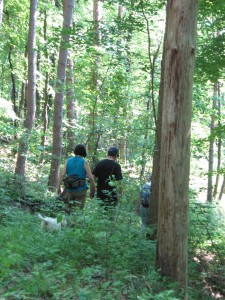 Today’s hike is canceled. Thunderstorms are predicted from 11 to 8 this afternoon. The Springwater Community Day is postponed and hiking during a thunderstorm is not recommended. Enjoy your indoor activities and join us next Sunday at Pat and Tony’s … Continue reading | 20th Annual ADK Outdoor Expo – 2017 9:30 am 20th Annual ADK Outdoor Expo – 2017 @ Beach area of Hundred Acre Pond Mendon Ponds County Park Jun 10 @ 9:30 am – 3:30 pm The 20th Annual ADK-GVC Outdoor Expo will be held on Saturday, June 10th 2017 at the Beach area of Hundred Acre Pond in Mendon Ponds County Park off Douglas Road. Outdoor activities and learning abound at this free event, … Continue reading Genesee Valley Greenway Passport Series – 2017 – Hike #3 10:00 am Genesee Valley Greenway Passport Series – 2017 – Hike #3 @ Brookdale Preserve & southward Jun 10 @ 10:00 am Genesee Valley Greenway State Park (GVGSP) Passport Hike Series–Brook Road to Morgan Road–Wegmans Hike #3 Saturday, June 10, 2017 at 10:00 AM Brookdale Preserve, on Brook Road, Scottsville, NY The GPS Coordinates: N43 04.577 W77 42.550 Meet at the Brook … Continue reading | |||||
| Conesus Lake Inlet 1:45 pm Conesus Lake Inlet @ Pat and Tony's Jun 11 @ 1:45 pm – 4:00 pm 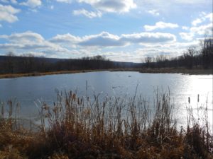 NOTE: This hike will start at 2:00PM (Please meet at 1:45 to allow for car-pooling). The Conesus Lake Inlet is an 1100 acre Wildlife Management Area (WMA). On June 11th we will walk 2 or 3 areas in this WMA. … Continue reading | ||||||
| Cohocton Valley 4:00 pm Cohocton Valley @ Deusenbery Farm Jun 18 @ 4:00 pm – 6:00 pm 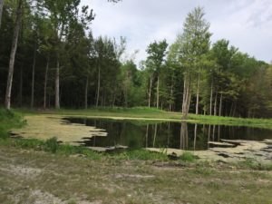 This Sunday is our first 4:00 hike of the summer season. Please plan to arrive shortly before 4:00 PM on Sunday, June 18. Our hike this Sunday will explore the fields and woods along the Cohocton River in Atlanta, NY … Continue reading | Springwater Town Public Hearing 7:00 pm Springwater Town Public Hearing @ Springwater Town Hall Jun 19 @ 7:00 pm – 9:00 pm This public hearing has been rescheduled for June 19. The Spirngwater Town Board will hold a Public Hearing for the adoption of its first Comprehensive Plan. | |||||
| High Tor 4:00 pm High Tor @ Basset Rd Parking Jun 25 @ 4:00 pm – 6:00 pm 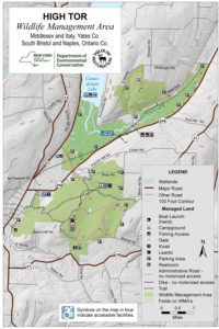 This Sunday we will hike the maintenance trails in High Tor WMA off Bassett and Brink Hill Rds. Naples. The footing is easy, along dirt tracks with grass that has recently been rough mown. There are a few slow rise … Continue reading |
The 20th Annual ADK-GVC Outdoor Expo will be held on Saturday, June 10th 2017 at the Beach area of Hundred Acre Pond in Mendon Ponds County Park off Douglas Road. Outdoor activities and learning abound at this free event, 9:30AM-3:30PM.
Presentations and interactive events are mostly centered around the beach area and contiguous areas of the adjacent parking lot.
Here is a hyperlink to ADK Outdoor Expo. http://www.gvc-adk.org/expo
And here is a hyperlink to an article about the 2015 Outdoor Expo, included for reference of the myriad type activities.
Genesee Valley Greenway State Park (GVGSP) Passport Hike Series–Brook Road to Morgan Road–Wegmans Hike #3
Saturday, June 10, 2017 at 10:00 AM
Brookdale Preserve, on Brook Road, Scottsville, NY
The GPS Coordinates: N43 04.577 W77 42.550
Meet at the Brook Rd Genesee Valley Greenway (GVG) Parking area.
The hike will be going southward from the Brook Road parking lot along the eastern edge of Brookdale Preserve. We will see remnants of the Genesee Valley Canal and the well preserved Lock #2.
The hike leader is Elijah Kruger from the educational staff of Letchworth State Park. The hike distance is 4.3 miles round trip. The Genesee Valley Greenway State Park is hosting this hike. There is no charge to attend this hike. Therefore, please consider joining us.
For more information, check the Friends of the Genesee Valley Greenway (FOGVG) website, their Passport page, and the complete 2017 GVG Passport Series.
– – – Additionally, the Genesee Valley Greenway State Park (GVGSP) Facebook page usually lists the upcoming GVGSP events, and the FOGVG Facebook page also lists numerous GVG events in our area albeit a greater proportion of events listed on this page may at times be in the “Southern Tier” portion of the GVG as planned by a group of hikers known as the Southern Tier Greenway Hiking Group (STGH or STGHG) who welcomes all to hike with them.
– – – We also have a short history of the Greenway.
NOTE: This hike will start at 2:00PM (Please meet at 1:45 to allow for car-pooling).
The Conesus Lake Inlet is an 1100 acre Wildlife Management Area (WMA).
On June 11th we will walk 2 or 3 areas in this WMA.
We will meet, prior to the hike, at 7980 State Route 256, Dansville NY (approx. half-way between Dansville and Scottsburg)
The trails are not maintained on a regular basis so some bush-whacking may be necessary. Because of the rainy weather the ground may be soggy. Recommend long pants and stout footwear. This is a good opportunity to see some nice ponds and possibly some wild life
Meet a Pat and Tony’s at 1:45 to get organized. Some of the parking areas are small so maybe we can cram into 4 or 5 vehicles.
After the hike all are welcome to meet at Pat & Tony’s for a social. Bring a dish to pass. Tony will attempt to cook some Zweiglers.
Directions
From Springwater: Turn (left 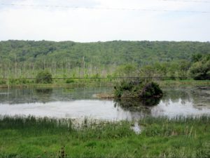 or Right) at light onto Springwater Hill (Rt 15), In 1.5 miles turn left onto Liberty Pole Road (CR 38) In 3.6 miles turn left onto Stage Coach Road (Rt 255) in 1.8 miles turn right onto Rt 256 (W Swamp Rd) in .3 miles you will arrive at Pat & Tony’s at 7980 State Route 256. (The last intersection prior to this location is Powell Road, on the left, we are in the blue house (sits back) on the left side after Powell Road. If you reach Springwater Road (CR1) you’ve gone too far
From Wayland: Start point Mobil/7-eleven on corner. Head west on Rt 63, (past the High School), go down Wayland Hill to Main St, Dansville, turn right on Perine Street and Perine street will turn into Route 256, proceed approx. 4.8 miles to 7980 State Rt 256 on left.
Will put a flag near diveway
This Sunday is our first 4:00 hike of the summer season. Please plan to arrive shortly before 4:00 PM on Sunday, June 18.
Our hike this Sunday will explore the fields and woods along the Cohocton River in Atlanta, NY (not GA, but NY). The hike will be through rolling hills and along farm roads and through forests. We will walk along the Cohocton River, so bring your fishing gear if you would like to catch some trout. Hikes for Climbers and Naturalists will be available.
 We will meet on a field road off of Rt 21. Watch for the Springwater Trails sign on Rt 21 and follow the road back to a parking area near the pond. Following the hike, join us for a “dish to pass” social with hamburgers and hotdogs on Cheryl’s grill. Bring a dish to pass and your own beverage, or make a small ($5) contribution to the social fund.
Directions:
From Wayland, Springwater and Dansville: From the traffic light in Wayland on Rt 15, follow NY 21N east toward N. Cohocton and Naples. In 3 miles you will pass over the Cohocton Creek at Bowles Corners. Continue for another half mile. The driveway will be on the right just before you pass the “School Bus Stop Ahead” sign. Look for the Springwater Trails sign. Continue for about 400 ft (0.1mi) down the farm road to park near the pond.
From Naples, Honeoye and N Cohocton: Take NY 21S from Naples. Turn right to stay on NY 21S through N. Cohocton. In 3.3 miles, the driveway will be on your left, just before the guardrails. Look for the Springwater Trails sign. Continue for about 400 ft (0.1mi) down the farm road to park near the pond.
This public hearing has been rescheduled for June 19.
The Spirngwater Town Board will hold a Public Hearing for the adoption of its first Comprehensive Plan.
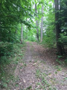
This Sunday we will hike the maintenance trails in High Tor WMA off Bassett and Brink Hill Rds. Naples.
The footing is easy, along dirt tracks with grass that has recently been rough mown. There are a few slow rise hills. We will pass 4 ponds along the way where ducks and turtles have been spotted.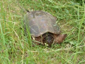
Let’s all meet at the Bassett Rd parking area at 3:45pm to leave a few cars. The remaining cars will then proceed to Brink Hill Rd maintenance trail parking lot.
Please remember to spray for ticks.
CLIMBERS will leave from Brink Hill Rd, staying right at the V, turning left at the intersection of the main trail then take the sharp left maintenance road to return to Brink Hill. Maps will be available. This route will probably exceed the 2 hours unless Char is setting the pace:~).
TOURISTS will also leave Brink Hill, stay right at the V, past the ponds to the main intersection. Time permitting, we will visit the Canandaigua Lake overlook, backtrack, then finish the hike along the maintenance road to Bassett parking.
NATURALISTS, should we have at least 2, will walk in from Brink parking, visit the ponds and retrace their steps back to the parking area.
The SOCIAL will be at Amy’s. Directions given at hike. Please bring a dish to pass or plan to make a donation. Meat will be provided. BYO drink. If you would like to drop your dish off prior to the hike, please let Amy know via the website’s contact address or directly, if you have her info.
DIRECTIONS: From Naples, take Main St south up Route# 53. Turn left on Italy Valley. Turn left on Bassett Rd at the curve. The parking area will be just after the first Bassett curve.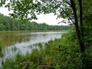
Little Rock City (a rather unique hike destination) is located in Rock City State Forest, and as cities go, well, it is not a city in the traditional sense, as occupied by humans, … it is a city of rocks. “Little Rock City” is one of three “Rock Cities” in Cattaraugus County, NY. [For the curious … The other two are: Rock City Park (a privately owned tourist attraction of huge rock formations and more), and Thunder Rocks in Allegany State Park may be considered by some to be a rock city.] Please don’t let “Little” in Little Rock City mislead you, the rocks are actually huge here, the diminutive is likely a mere delineation from the larger “Rock City Park”.
For Sunday, July 2nd 2017, ST has not planned a ST hike (that was announced at the 6/25 ST hike) . BUT WAIT- do not be dismayed, here is a hike opportunity at Little Rock City that some ST hikers may be willing to travel to and find the hike well worth the distance of travel. (This hike opportunity came to ST on Monday morning 6/26, and by Monday afternoon this hike got posted for ST and other hikers too.)
The Finger Lakes Trail (FLT) runs thru Rock City State Forest, as do some other trails. Here is an opportunity to avail yourself of these trails with some like minded hikers.
This is a hike provided by the group Chautauqua Hikes, and likely you’ll be joined by some hikers from Olean Area Hiking Group (yes, the same group that ST did a joint hike with at Hanging Bog three or so years ago). Hikes are open to other hikers.
The two paragraphs below in italics are the hike particulars as provided by “Chautauqua Hikes”.
Come out and join us for a hike at Little Rock City on Sunday July 2nd. Various skill levels are welcome. We will meet at the park and ride on Rt 60 at 9:30am to carpool to the trail. This is a trail that we did a few times years ago but not recently. Bring
a lunch and water. Dress for the weather. The trial is hilly and rocky.
I’m not sure of the distance but we will be out all day, including travel
time.
This state forest received its name due to the massive boulders the size of
houses which are naturally arranged so that they resemble a city with
“streets” running between them. This unique “city” is formed by many
factors including a massive resistant conglomerate bed, erosion of the weak
shale base and soil creep. The conglomerate bed actually has its own
geological designation known as Devonian Salamanca conglomerate. A
conglomerate is a rock consisting of individual stones that have become
cemented together.
– – Please note, the carpool point (park & ride on Rt 60 at 9:30am) listed in the two italics paragraphs above is not one that ST hikers would use, as it is in Jamestown area well west of Little Rock City. ST hikers would be coming from the east.
Basics of this hike – for ST hikers:
Hike start time for this “Little Rock City” hike is targeted as 10:30AM. Hike Leader is Eileen of Chautauqua Hikes. Bring a lunch and water. Dress for the weather. The trial is hilly and rocky. Various skill levels of hikers are welcome.
Parking for this hike and Hike start locale are both at the former CCC Camp Seneca on the west side of Hungry Hollow Rd. Map or GPS coordinates ~ 42.224246, -78.699124
Carpool for ST hikers Carpool (unsupervised) is at Springwater Town Hall with gathering time at 8:05AM and depart time of 8:15AM. (A potential carpool point in Wayland is under consideration at present.)
Driving Directions (from Springwater Town Hall): Drive time to the hike from Springwater is ~ 2 hours. Rt 15 south; to Rt 21 south; to Rt 36 north (very briefly) ; to Rt 17 Southern Tier Expressway (aka I-86) west. From Southern Tier expressway take Exit 23 to Rt 219 north (Business) / Rt 417. From 219 north / Rt 417 turn right onto Killbuck Rd (aka Co Rd 49), which will eventually merge back into Rt 219 north. Continue briefly on Rt 219 north (aka Buffalo-Pittsburgh Hwy, likely named for the routing of the railroad of same name) crossing over Great Valley Creek, then just past Great Valley Creek and the large antique place on the left turn left onto Hungry Hollow Rd. The CCC Camp Seneca parking area is a couple miles down Hungry Hollow Rd on the left/west. – – – Hint:The parking area is a short distance after passing Perrault Rd which intersects Hungry Hollow Rd (on the right/east). If you reach the intersect of McCarthy Hill Rd (on the right/north) while on Hungry Hollow Rd you’ve gone to far.
Map or GPS coordinates (approximate) for CCC Camp Seneca parking area (trailhead access to Little Rock City) ~ 42.224246, -78.699124 ( A reminder: Bear in mind in some areas, especially more remote areas, GPS units may not give accurate routing directions. Oooo, err, uhmm, RECALCULATING. ;~)
– – – (optional, not required) – – – Interested hikers should feel free to “log-in” to the ST website (as an authorized user) and post “comments” to this post (perhaps confirm who is going and advance carpool arrangements, etc). (Alternatively, you may also send an e-mail to: damhikes [at] springwatertrails.org ; and communications efforts can be coordinated via e-mail.)
As a primer, here at two links about Rock City State Forest (and more), both are on CNYhiking website. You’ll find some photos of Little Rock City in the links. – – A shout out of “THANKS” to Ed of CNYhiking for the plethora of fantastic info he has cataloged for use by hikers and other outdoor enthusiasts … all listed in the CNYhiking.com website!
http://www.cnyhiking.com/RockCityStateForest.htm
http://www.cnyhiking.com/NCT-RockCityStateForest.htm
>>> most recent update to this hike event post by author – Friday 6/30/2017 ~ 12:25PM <<<
Please check this post for any additional info or changes as we approach hike day.
Just Sayin’ … after the hike, when returning to the Finger Lakes area, hikers may wish to consider taking in the free concert performed by Bluegrass group “South 79” at Vitale Park located at the head of Conesus Lake in Lakeville. Concert time is 6-8PM. Parking may be a bit of a challenge, … none-the-less an additional chance to kick-back and get in some recreatin’ on a Sunday of Independence Day weekend.
Lastly, a suggestion, toward a future ST hike. … If you go to this Little Rock City hike, perhaps keep a perspective eye toward possibility of planning a future ST hike at Little Rock City, which for sure would be a rare distance travel exception hike for ST if our group decides there is willingness to make the travel.
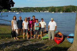 For the last two years the happy kayakers have ventured out into the center of the Annual Conesus Lake Ring of Fire, while others less willing or non-kayakers enjoyed watching the fireworks from the shore. This year Springwater Trails is invited to join the happy kayakers for a picnic at 6:00 at Long Point Park in Geneseo to celebrate the 4th of July. The kayaking will launch at 8:00 and return at 10:00.
Because Conesus Lake can be rough at times and because of the return in darkness, only experienced kayakers will participate. Also, we’ll only kayak if the weather is favorable.
 Thanks to Jim Clark, Marine Patrol on Conesus Lake, we have the privilege of grouping at the Sheriff’s Substation on the lake. The park is expected to be crowded to we will need to limit the number of hikers to 20. Please RSVP if you are planning to join us.
Fireworks are loud and close by. Dogs on leashes are allowed, but not encouraged for the comfort of both the dog and other spectators.
Traffic will be heavy, so plan ahead. Please arrive at 6:00 to drop off your kayaks and park on the grounds. Bring a dish to pass, a beverage, a lawn chair or blanket, flashlight, and mosquito repellent. We will picnic at 7:00. The excitement begins around dusk.
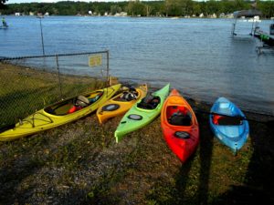
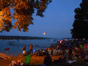 Kayakers will need to have not only life preservers, but headlamps and bright lights on their boats as we will be on the lake amidst motorboats. Staying close to the shoreline, we will experience seeing the Ring of Fire from the lake. We must stick close together and have a buddy system since it is easy to get disorientated in the dark. Caution should be taken to avoid other boats and to be as bright as possible. In addition, powerful fireworks will explode directly overhead and some sparkles may be hitting the water around us. Communication is important.
 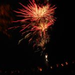 We will return to Long Point, planning additional time to secure your kayak on your car in the dark.
The Conesus Lake of Fire is an incredible local event in our area. If you have not experienced it, come join us for a fun, memorable time!
On Sunday 9th July, Springwater Trails will be cleaning up the Wheaton Hill Trails.There are two loops on each side of the road. We will split into four groups, with each group taking one of the loops. We will hike the loop, clearing any branches on the trail, clipping anything that is interfering with with hiking the trail, and we will take notes concerning larger items that need to be done on the trail in the future.
NOTE: If you plan to use a weed whacker, PLEASE BRING EYE PROTECTION! These devices can kick up a lot of dust and small stones.
Bring gloves to protect your hands, loppers to cut branches and if you have one, a small saw for branches that are too large for the loppers. This trail tends to grow a LOT of grass, so we’ll need as many weed whackers as people can bring..
If the weather is good we’ll have a picnic social after the hike; bring a dish to pass and something to drink with you. If it’s cool or threatening to rain then we’ll skip the social this time.
Directions: Wheaton Hill is the first right turn north of the intersection of Rt 15 and Rt 15A in Springwater (0.9 mile north of the intersection). The trail head is 0.5 miles up Wheaton Hill just before the road turns straight east and heads up the main hill. More details are on the directions page.
What to bring:
- Gloves and clippers – hand clippers or long handled loppers for larger branches.
- A weed whacker if you have one, with gas mixture and extra string.
- Small bow saw.
- Plastic grocery bags in case you find any litter.
- Water to keep hydrated.
This Sunday hike is the first in a series. Over the next year we are planning to hike the entire Bristol Hills Branch I(BHB) of the Finger Lakes Trail (FLT). On the third Sunday of each month, we will hike a different section of the trail. The Climbers will do the longest hikes, completing the entire trail including all road walks. The Tourists will generally skip the road walks, making their hikes a bit shorter. And finally, the Naturalists will hike a selected portion of the trail, based on length and terrain. These hikes will be one way hikes, so expect some shuttling of cars.
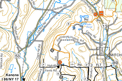 Our first BHB hike is on the Finger Lakes Trail map B3 (see the images). We will meet on Clark Hill Rd at the corner with LaRue Rd in Bath, NY. From there, some cars will drive to the north end of the hike on Mitchellsville Rd, the rest will drive to the south end of the hike at the corner of Ferris Rd and Harrisburg Hollow Rd.
The Climbers will car pool to the north end of the hike at Access Pt 18 on Mitchellsville Rd and will hike south. The hike will start with a long steep uphill, along a ravine. Once Lake David is reached, the trail flattens out, to a shallow, but steady climb to Harrisburg Hollow Rd. Crossing Harrisburg Hollow Rd, the hike will continue to the point where the BHB ends at the Finger Lakes Trail. Turning right, the climbers will follow the FLT west along the abandoned portion of Ferris Rd. When the FLT turns into the woods, we will continue on Ferris Rd back to the Tourists and Naturalists cars.
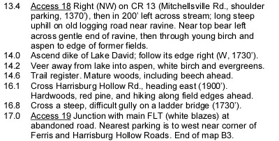 The Tourists and Naturalists will car pool to the south end of the hike. They will turn onto Harrisburg Hollow Rd and park the cars. The Naturalists and tourists will hike along Harrisburg Hollow Rd continuing north. In about half a mile, the Bristol Hills Branch will cross the road. The Tourists will turn left and follow the trail north (downhill) to Access 18 on Mitchellsville Rd where we hope to find the climbers cars and return by car to the southern start point. The Naturalists will turn right and follow the trail to the abandoned Ferris Rd. Turning right, they will follow the FLT and Ferris Rd to the top of the hill, and continue to the cars at Harrisburg Hollow. This trail passes through both forest and open fields. On the last leg of the BHB, you will cross a gully on a ladder bridge – a clever solution to a difficult crossing. If the Naturalists reach the FLT before 5:15, they may want to explore the FLT to the east, before returning to the cars.
We will do a picnic social after the hike on Harrisburg Hollow Rd and enjoy a beautiful view to the west. Bring a dish to pass and your own beverage (or contribute to the social fund). If it is raining, we will make other arrangements.
Directions:
From Springwater (and Wayland): Head south on NY-15 through Wayland. Turn left to get on I390. [If the entrance to I390 is still closed for construction, turn left on NY-415 just before going under I390. In 6.2 miles, turn righ onto Cohocton Look Lake Rd and in a half mile, turn left onto I-390S]. Continue onto I-86 (NY-17) east. Take Exit 37 and turn left only NY-53 north. In 2.8 miles, turn right onto Larue Rd, Take the first right onto Clark Hill Rd. We will meet here.
From Rochester and Dansville: Head south on I390 and join I-86 East. Take Exit 37 and follow the directions from Springwater.
From Bath and south: Head west on I-86. Take Exit 37 and follow the directions from Springwater.
From Naples and north: From NY-21 on the south edge of Naples, follow NY-53 South for 19 miles. Turn left onto Larue Rd. Take the first right onto Clark Hill Rd. We will meet here.
To get from the meeting location to Mitchellsville Rd: Turn right (North) onto Larue Rd for 2.2 miles. (Larue becomes Garner Rd in 1.3 miles) At the T, turn right onto CR 13 (Mitchellsville Rd. In 1.1 miles, the trail will be on the right. Best parking is on the right.
To get from the meeting location to Harrisburg Hollow Rd at Ferris Rd: Continue on Clark Hill Rd for 1.3 miles. Continue straight through the 4-way intersection. At the next intersection, turn left onto Harrisburg Hollow Rd. Park right there. (If you had continued straight, that would be Ferris Rd which becomes the FLT.) Warning: most of this route is dirt road.
To get from the North end back to the South end: As you come out of the trail to the cars, you will want to drive to the left on Mitchellsville Rd. Head north on Mitchellsville for 1.1 miles. Turn left onto Garner Rd. When Garner Rd turns right, continue straight onto LaRue Rd for 1.3 miles. Turn left onto Clark Hill Rd for 1.3 miles. Continue straight through the 4-way intersection. At the next intersection, turn left onto Harrisburg Hollow Rd. The Tourist cars should be there.
[ngg_images source=”galleries” container_ids=”15″ display_type=”photocrati-nextgen_basic_imagebrowser” ajax_pagination=”0″ order_by=”sortorder” order_direction=”ASC” returns=”included” maximum_entity_count=”500″]
If you have pictures of this section of the Bristol Hills Branch, please add them to our gallery. [ngg_uploader id=15]
Looking for brochure.or mailing list so I can receive it in the mail.
Nothing opens up for mailing list.
There’s all kinds of very bizarre ads and post for viagra and other drugs above on calender page.
Please let me know if there’s a brochure available