
Hikes led by Springwater Trails are generally held on Sunday afternoons and appear in this calendar in green.
| Sun | Mon | Tue | Wed | Thu | Fri | Sat |
|---|---|---|---|---|---|---|
| First Day Hike 10:00 am First Day Hike @ Genesee Valley Greenway State Park Jan 1 @ 10:00 am – 12:00 pm At 10:00 a.m. on New Years Day, you and your family and friends are invited to meet at at the Genesee Valley Greenway State Park’s Brook Road parking lot in the town of Chili. A walk one mile south will take … Continue reading New Years Day – NO HIKE 2:00 pm New Years Day – NO HIKE Jan 1 @ 2:00 pm – 3:00 pm Springwater Trails is relaxing after a busy 2016. Please join the Genesee Valley Greenway State Park on New Years Day for a hike on the Greenway. Or, check the rest of the calendar for organized hikes near Springwater. | ||||||
| Genesee Valley Greenway – Cuylerville to Piffard 2:00 pm Genesee Valley Greenway – Cuylerville to Piffard @ Greenway Parking Area on Rt 20A Jan 8 @ 2:00 pm – 4:00 pm Sunday’s destination is that section of the Genesee Valley Greenway between Cuylerville and Piffard. It has farmland, large ponds, woodlands, pastures and large oaks. All groups will meet at the Greenway Parking and Kiosk Area on the north side of Rt 20A in Cuylerville. … Continue reading | ||||||
| Mendon Ponds 2:00 pm Mendon Ponds @ Mendon Ponds Jan 15 @ 2:00 pm – 4:00 pm 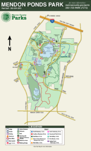 Springwater Trails continues it’s practice of scheduling a hike at Mendon Ponds park the same day as the annual Monroe County Winterfest. The impressive agenda of the 22nd edition of Winterfest is at http://www2.monroecounty.gov/parks-winterfest . The Winterfest activities start at 11am, … Continue reading | ||||||
| Harriett Hollister Spencer 2:00 pm Harriett Hollister Spencer @ Harriett Hollister Spencer State Recreation Area Jan 22 @ 2:00 pm – 4:00 pm  Today’s event will start in the Harriett Hollister Spencer State Recreation Area parking lot at the entrance to the park. We will break into 3 groups, Climbers Tourists and Naturalists. We are hoping for snow as this gives a chance … Continue reading | Hike Harriet Hollister with snow?, “just 6 days later” 10:00 am Hike Harriet Hollister with snow?, “just 6 days later” @ Harriett Hollister Spencer State Recreation Area Jan 28 @ 10:00 am – 12:30 pm 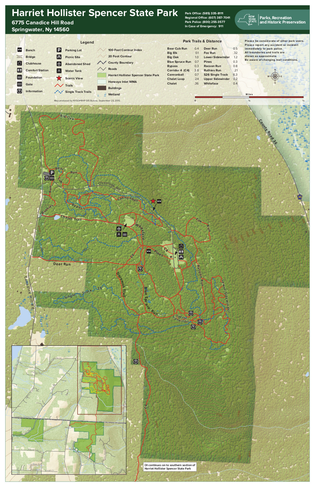 For those Springwater Trails hikers who revel in hiking Harriet Hollister Spencer State Recreation Area (HHSSRA aka HHSMRA where M is Memorial) with snow, well the ST hike on Sunday 1/22/2017 did not support that as the ground was … Continue reading | |||||
| All Western Evergreen Farm 2:00 pm All Western Evergreen Farm @ AWTF Jan 29 @ 2:00 pm – 4:00 pm  A Treasure Hunt is part of this hike. Come look for four GOLD, four SILVER, and four BRONZE tickets hidden in the trees all over the farm. The only rule is that if you find a ticket, then you need … Continue reading |
Sunday’s destination is that section of the Genesee Valley Greenway between Cuylerville and Piffard. It has farmland, large ponds, woodlands, pastures and large oaks. All groups will meet at the Greenway Parking and Kiosk Area on the north side of Rt 20A in Cuylerville. Be prepared to cross-country ski, snowshoe, or hike depending on conditions. Dress in layers and pack water and a snack.
Information on the Genesee Valley Greenway can be found on the NYS Parks, Recreation and Historic Preservation website at: http://nysparks.com/parks/189/details.aspx .
Hiking Groups
Climbers will go north to Piffard and make a round trip back to Cuylerville – 8 miles.
Tourists will car pool to Piffard and go south one way to Cuylerville – 4 miles.
Naturalists will go north and spend time looking for winter birds, animal tracks and other interesting things along the trail. The distance will be determined by the group.
Social
*** Note Change in Location. There will be an after hike social in the tavern at the Yard of Ale, 3226 Genesee Street (Route 63), Piffard. The Yard of Ale opens at 4:30.
Directions to Meeting Place
From Springwater: Take NY-15N west from the flashing light for 1.5 miles. Turn left on Liberty Pole Rd (CR 38). This road changes names and numbers (CR 1A and then CR 1) but continue for 8 miles. Turn right onto NY-63N for 9.4 miles. Take a sharp left turn onto US-20A W (NY 39 also). The parking area is on the right in 2.4 miles just before US-20A turns a sharp left in Cuylerville.
From Wayland: Take NY-21 south to Interstate 390. Turn right to take I390N for 22 miles to exit 7 – NY 408. Turn right onto NY-408N then slight left to continue on NY-63 for 3 miles. Take a sharp left turn onto US-20A W (NY 39 also). The parking area is on the right in 2.4 miles just before US-20A turns a sharp left in Cuylerville.
From Honeoye: For the entirety of the trip from Honeoye to Cuylerville, you’ll take US-20A W for about 22 miles of driving to the trailhead parking area. Its just that simple! But routing can be a bit confusing in some places, such as a junctions and where there are concurrently running routes, so watch signs carefully. ⇒Further detailed description (if you need it): Follow US-20A W from the hamlet of Honeoye through the hamlet of Hemlock and villages of Livonia and Geneseo and then heading into the small hamlet of Cuylerville. (Watch signs for US-20A carefully on the SW side of the village of Geneseo, or you may go astray.) SW of village of Geneseo, US-20A W & NY-39 W & NY-63 S all briefly run concurrently. Staying on US-20A (& concurrently running NY-39 W), from the US-20A (NY-39 also) split from NY-63 at the SW side of Geneseo, you’ll then travel 2.4 miles to the trailhead parking area located on the right just before US-20A (NY-39 also) turns a sharp left in Cuylerville. (By-the-way, as a digression, a short-cut on Big Tree Rd in the towns of Richmond and Livonia, circumventing a segment of US-20A, saves a mile but not any time).
Springwater Trails continues it’s practice of scheduling a hike at Mendon Ponds park the same day as the annual Monroe County Winterfest. The impressive agenda of the 22nd edition of Winterfest is at http://www2.monroecounty.gov/parks-winterfest . The Winterfest activities start at 11am, the hike begins at the usual time of 2pm.
 Springwater Trails hikers will meet at the parking area at the intersection of Pond Road and Douglas Road, marked with a Purple P on the current map. We will all access the East Esker (Green) trail across Douglas Rd and walk the section South to the Horse Trailer parking lot at Pond Rd
NOTE: Because of the heightened activity at Mendon Ponds for Winterfest, dog owners should plan to keep their dogs on a short leash. Specifically, dogs should stay away from the Stewart Lodge and the K9 Search & Rescue dog, and from the Seneca Siberian Husky Club Sled Dog Race on South Meadow Trail. The races will be over at 1:00 so our hike should not interfere, but remember to be a responsible dog owner.
Naturalists can break off from the pack at Pond Rd and wander the Green trail.
Tourists will cross Pond Rd and loop the Southern Meadow (Red) trail, and then retrace the same Green trail segment to the parking lot, for about 3.5 miles of mostly flat trail.
Climbers will have the option of extending the distance with parts of the Quaker Pond (Purple) trail where it meets the Red trail, for a maximum of around 6 miles, again mostly flat.
Following the hike, we will gather at the Brewery Pub and Grill at 8 W Main S in Honeoye Falls for refreshment and warm conversation.
Directions:
From Springwater: Head north on 15A for 21.6 miles through Hemlock and Lima. Take a slight right exit to Honeoye Falls. Stay on W Main St into the villiage where you will pass the Brewery Pub and Grill on the right at the intersection with NY 65 (1.9 mi). Continue straight onto NY 65 for 4.4 mi. (At 2 miles, you will go around a traffic circle. Stay on NY 65.) Turn right onto Pond Rd. The parking area is on the left a little over 1 mile down Pond Rd at the intersection with Douglas Rd, where Pond Rd makes a Right Turn. NOTE: to get to the Evergreen Shelter before the hike for Winterfest events, stay on NY 65 for another 1.2 miles past Pond Rd. Turn right on Canfield Rd. The shelter is on the right 0.7 miles down Canfield.
From Honeoye: From US 20A, head north on CR 37 for 8.2 miles to W Bloomfield. Continue straight on NY 65 for 0.7 miles, then continue straight onto CR 35/W Bloomfield Rd for 6.6 miles. Turn left onto Pond Rd. Inside Mendon Ponds Park, the road will come to a T – the parking area is visible from the intersection. Note: to get to the Evergreen Shelter before the hike for Winterfest events, stay on W Bloomfield Rd for another 1.7 miles past Pond Rd. Turn left on Canfield Rd. The shelter is on the left 2.1 miles down Canfield.
From Rochester: Exit I590 at Monroe Ave toward Pittsford. Turn right (south) onto NY 65 (Clover St). In 6.7 miles, turn left onto Pond Rd. The parking area is on the left a little over 1 mile down Pond Rd at the intersection with Douglas Rd, where Pond Rd makes a Right Turn. NOTE: to get to the Evergreen Shelter before the hike for Winterfest events, turn left from NY 65 in 5.5 miles onto Canfield Rd. The shelter is on the right 0.7 miles down Canfield.
From the Evergreen Shelter: Head west on Canfield Rd for 0.7 miles. Turn left onto NY 65 for 1.2 miles. Turn left onto Pond Rd. The parking area is on the left a little over 1 mile down Pond Rd at the intersection with Douglas Rd, where Pond Rd makes a Right Turn.
 Today’s event will start in the Harriett Hollister Spencer State Recreation Area parking lot at the entrance to the park. We will break into 3 groups, Climbers Tourists and Naturalists. We are hoping for snow as this gives a chance to use our snowshoes and cross country skis. Those that decide to ski vs those that snowshoe may find the need to use different trails to keep their hike to 2 hours. If there is no snow, we will hike in 3 groups as usual.
The climbers will take Ruthie’s run across from the parking lot. Continue out to The Chalet trail. Continue on Chalet trail and turn right on the Bypass trail for a short time and then right onto C4. Stay on C4 the rest of the hike.The hike will end out at the junction of Townline Rd and Canadice Hill Rd. Those that wish can be shuttled back to the parking lot. This is a longer walk for snowshoes so they may want to turn off back in the park and follow the bicycle root inside the park.
The Tourists can follow the snowshoe hikers along the bicycle trail that wanders thru the park. This trail doesn’t show up on some maps but in general, follows the trails around the outside of the Park occasionally crossing more established trails. This is a less evasive trail to skiers that might be using the main trails.
Naturalists can pick any of the trails in the park and stop at their leisure.
Bring your gear as needed. Hiking poles and traction devices are recommended especially if there is no snow the trails are icy. Since it is expected to be around 50 tomorrow, the after hike social will be in the parking lot at the park rather than indoors at Sammy’s Restaurant in Springwater. Pam will bring a grill and some chili and John will bring hot dogs and rolls. If you wish to bring anything to add at this short notice, please do – but at any rate, everyone is welcome to stay for hot dogs.
Directions: From 1 mile north of Springwater on Rt. 15A, turn up Wheaton Hill RD. Drive all the way to Wetmore RD. and turn left. Continue straight onto Canadice Hill RD. and drive another 2 miles to the park on the right.
From Honeoye: Take County Road 37 and continue straight onto Canadice Hill Rd. to the park on the left..
For those Springwater Trails hikers who revel in hiking Harriet Hollister Spencer State Recreation Area (HHSSRA aka HHSMRA where M is Memorial) with snow, well the ST hike on Sunday 1/22/2017 did not support that as the ground was devoid of the white stuff. But then it snowed on Tuesday 1/24/2017 and is predicted to do so again before Saturday 1/28/2017. Which leads me to citing a second chance for participation in a group hike where perhaps there may be snow, albeit this one on Saturday 1/28/2017 a mere 6 days since ST Sunday 1/22/2017 hike.
This hike is a scheduled hike on the Genesee Valley Hiking Club (GVHC aka GVHG where G is Group) hike schedule, and Ryan B. is the Hike Leader (& Planner). Some ST hikers are acquainted with Ryan as result of his hike leads and shared hiking enthusiasm.
The salient info for this hike is below in quotes, from the GVHC website. Hike start time is 10:00AM, likely most folks from ST will not benefit from use of the 9AM carpool as it is in Bushnell’s Basin. Please know that there are no dogs allowed on this or any other GVHC hike.
“January 28/Saturday Strenuous/hilly 6-7 mile hike. Harriet Hollister Spencer Memorial Recreation Area. Meet at Bushnell’s Basin Park & Ride at 9 a.m. Hike starts at 10 a.m. at Harriet Hollister. Ryan B. 802-999-8554 #6016″
( #6016 is the GVHC assigned sequential hike number for this hike.)
Rules for hikers on GVHC hikes are much the same as are rules for ST hikes, with the most glaring contrast perhaps being the no dogs rule. Please note the 12:30PM hike end time listed in this ST post is a mere guesstimate.
Of course, no guarantee that there will be snowpack on Saturday, and if not, well, no blamin’ the local meteriologist or weather-person. The adage … any hike is a good hike.
– – – And regardless of snow or not, Traction Devices (TDs) may be in order as trails can be icy even if there is no snow. There was a comment for the Sunday 1/22/2017 ST hike that trails were in fact icy!
Directions to the hike:
From Springwater: From 1 mile north of Springwater on Rt. 15A, turn right onto (and up) Wheaton Hill Rd. Drive all the way to Wetmore Rd. and turn left. Continue straight onto Canadice Hill Rd. and drive another 2 miles to the HHSSRA entrance road parking lot on the right.
From Honeoye: Take County Road 37 and continue straight onto Canadice Hill Rd. to the HHSSRA entrance road parking lot on the left
Note: The entrance road parking lot is siutate at Canadice Hill Rd & the entrance road (aka Overlook Rd) . This time of year the entrance road (aka Overlook Rd) may be gated to restrict “road vehicle” access past the entrance road parking lot. Regardless (gated or not), the hike meet point & start point is at the entrance road parking lot (Canadice Hill Rd & Overlook Rd), not the entrance road terminus which is much further “inside HHSSRA”.
Climbers’ route
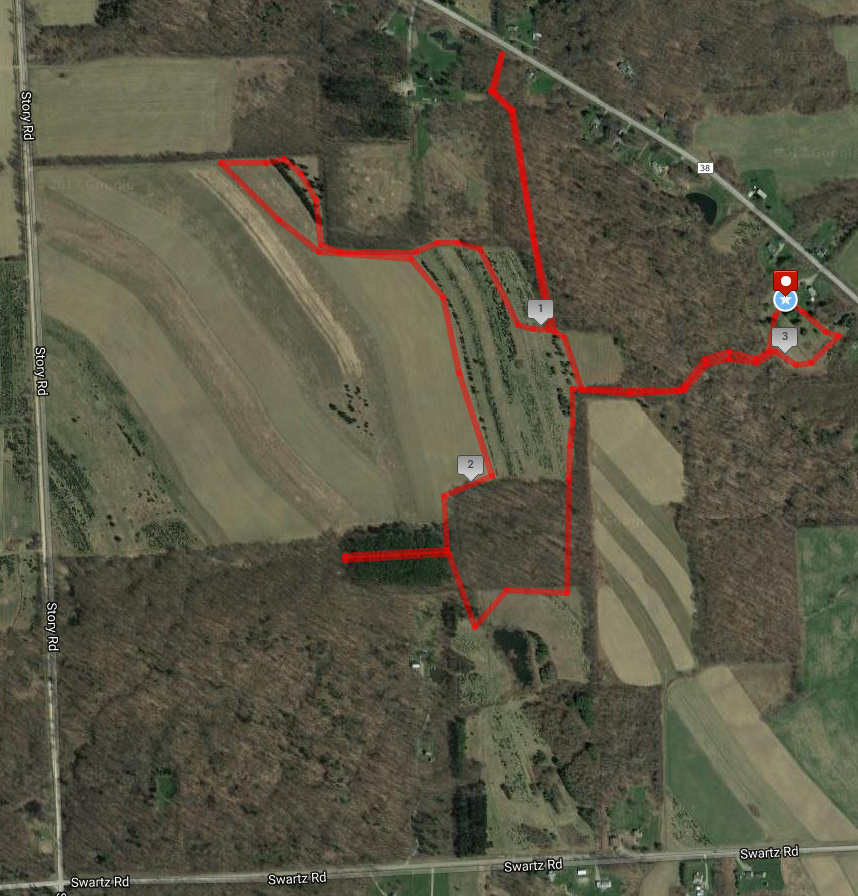
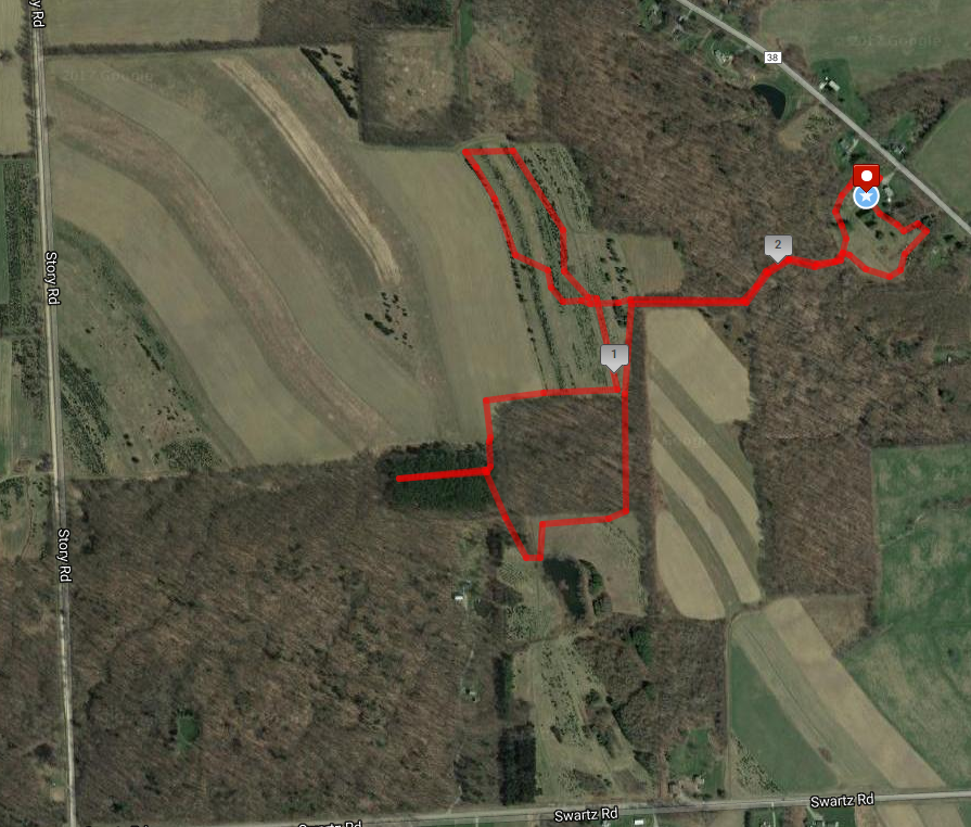
A Treasure Hunt is part of this hike. Come look for four GOLD, four SILVER, and four BRONZE tickets hidden in the trees all over the farm. The only rule is that if you find a ticket, then you need to help someone else find the next one. The 12 tickets are redeemable for treasures at the social afterwards at the house at 6840 Liberty Pole Road.
People had lots of fun looking for the Chamber of Commerce Golden tickets in the trees the last two Christmases as part of Shop Small in LivINgston County, so this is what gave me the idea. People like hunting for mushrooms, so why not hunt for other “treasure”?
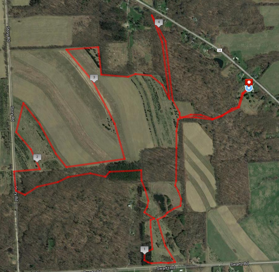
We will have three hikes. All hikers will take the farm road to the fields at the top of the hill and explore the woods and fields of Christmas Trees planted over the last 50 or more years. The Climbers will follow a 4 mile route around the pond in the south field, then bushwhack through the Spruce woods near Swartz Rd. Then a walk through the Cathedral Pines will bring us out on Story Rd. From there we will pass through several Christmas tree plantations ranging from 40 year old trees to trees planted just last spring.
Tourists’ route
The Tourists will travel 3 miles around the upper fields in a counter clockwise direction. They will take a side trip down to Liberty Pole Rd through hardwoods and a second branch through the Cathedral Pines, with the remainder of the hike checking out the various Christmas trees.
Meanwhile, the Naturalists will start with a tour of the unusual trees near the house including Dawn Red Wood, giant Concolor fir, Colorado Spruce, Englemann Spruce and Alaska Yellow Cedar. After climbing to the upper fields, with a short stop at the half-way bench, the naturalists will walk through the Fraser and Korean Fir trees, and under the beautiful Cathedral Red Pines before returned to the Sequoia, Western Red Cedar and Black Walnut trees near the house.
Naturalists’ route
Following the hike, Katherine will host a social at the farm house. Bring a dish to pass or make a contribution to the social fund. Membership forms for Springwater Trails will also be available. Bring your own beverage and redeem your treasure hunt ticket.
Directions to the hike are available here.
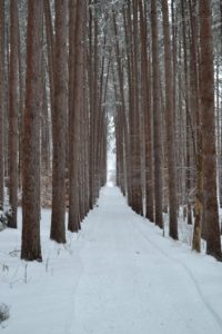 The Feb 5 Hike will take place at Cumming Nature Center in the hills above Naples NY. The Nature Center is an extension of the Rochester Museum and Science Center.
Dress warm. If conditions are right snow-shoeing is available.
There is a small fee to access the Center. Fees have been paid so just identify yourself , at the desk, as part of Springwater Trails Hiking Group.
You may want to arrive early to see the exhibits (and use the bathrooms) prior to the hike. (Additional donations are welcome)
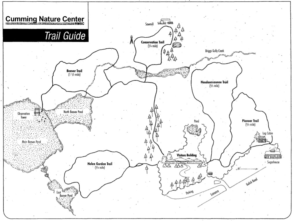 There are several interesting trails (The Beaver Trail and Conservation Trails are great). Maps will be available. We will split into groups and enjoy a nice walk.
Visited Nature Center 2 Feb. Some trails are off limits for hiking as they are being groomed for Cross-country skiing. There are still some nice trails to walk (I visited a good portion of those today) If the area gets another 2″ of snow between now and Sunday the cross-country ski trails will be opened. I will contact Cumming and leave a message if skiing is available. Bring your own or rent ski equip for $15.
Directions
From Rochester and points North: Take 390 South to Routes 5 & 20, Proceed to Rt15A in Lima. Head South on Rt15A to Route 20A in Hemlock, Head East on 20A to East lake Road in Honeoye. Proceed South on East Lake Road to County Road 33, (there are signs pointing the way from the junction of East Lake Road and County Road 33). Turn East on County Road 33, then Southwest on Pinewood Hill Road. This becomes Gulick Road. After 4.7 miles the CNC entrance will be on the right
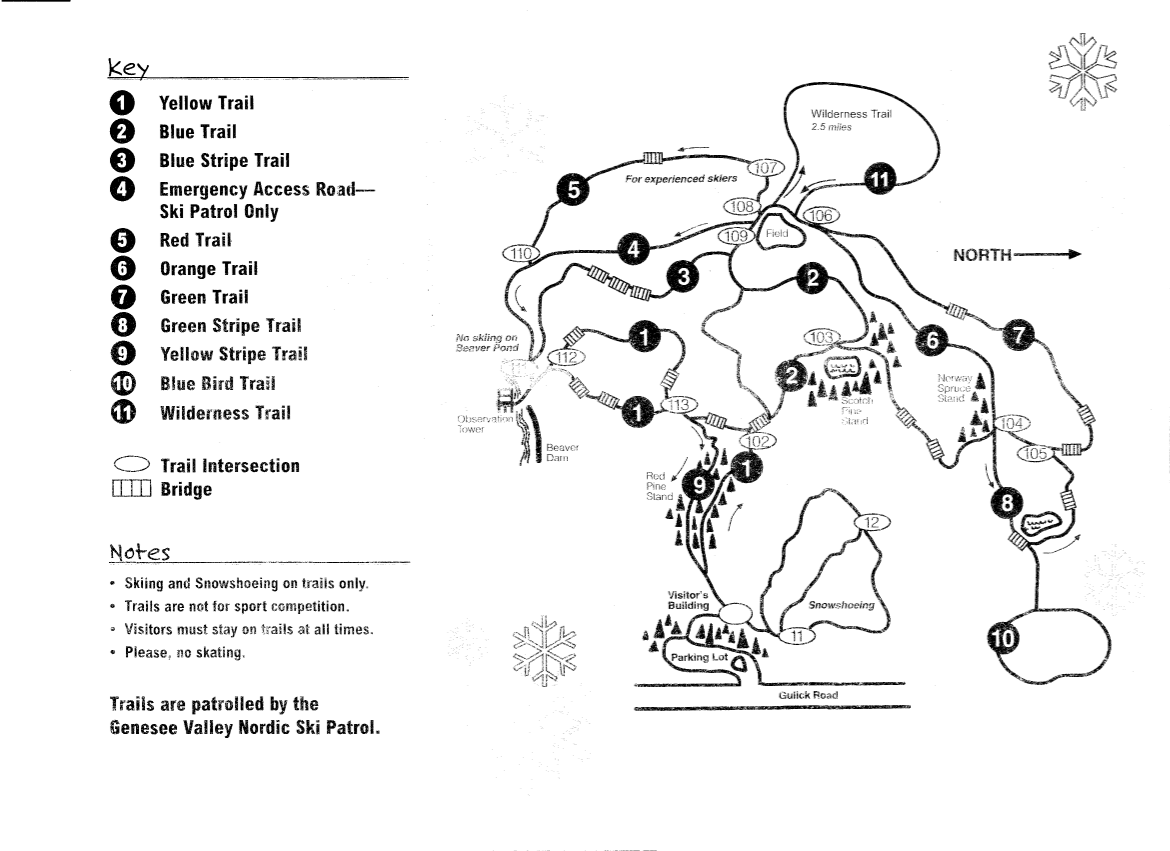 From Springwater: Go North on Rt 15A to Route 20A in Hemlock, Head East on Rt 20A to East Lake Road in Honeoye. Proceed South on East Lake Road to County Road 33 (Signs point the way from the junction of East Lake Road and County Road 33). Turn East on County Road 33, then Southeast on Pinewood Hill Road. This becomes Gulick Road. After 4.7 miles the CNC entrance will be on the Right.
From Wayland, Naples, and points South: Follow NY 21 East from Wayland,thru N.Cohocton to Naples (11.4miles). Turn Left onto Clark Street (County Hwy36), heading North (Next to Middletown Tavern). Take first Right onto Gulick Road. Follow Gulick Road for 6.6 miles. CNC will be on the lLeft.
______________________________________________
The after-hike Social will be at the Middletown Tavern (1835 Main St.,Naples NY), the intersection of County Hwy 36 and Rt 21.
Turn Right out of the CNC. onto Gulick Road. After 7 miles turn Left onto County Hwy 36.. Follow Hwy 36 until immediately before the intersection of Rt 21. The Tavern is on the Right.
 The Penfield Trails Committee will host its annual ‘Indoor Hike’ on Saturday, February 11, 10:00 am at Penfield Town Hall Auditorium, 3100 Atlantic Avenue. There will be a presentation entitled “Letchworth’s Portage Viaduct – New and Old”, information on trails groups from around the Rochester area, and light refreshments will be served. This event is free.
Please click on the poster to the right for a full size version.
Chris Costello, professional land surveyor, will speak about the 1875 Portage high bridge / railroad viaduct high above the Genesee River in Letchworth State Park. Costello will give an inside look at the construction of the new bridge in progress. Learn the history and the future of Letchworth rails and trails. Hikers, history buffs, and rail fans – lace up your boots and join us!
“This year’s speaker will give participants a rare behind-the-scenes glimpse of the much anticipated construction of the new railroad bridge,” says Nels Carman, Penfield Trails Committee chair. “This iconic structure has an interesting past and a promising future.”
While the “hike” is free, participants are asked to pre-register by calling Penfield Recreation at 340-8655, option 0. (requested, albeit not required)
Penfield Trails Committee is always seeking volunteers to serve on its planning committee, as well as to do manual labor for trails maintenance. For more information, please call Penfield Recreation at (585) 340-8655.
For general information – Penfield Trails Committee leads one guided hike per month March through January, and the twelfth hike of the year is the annual ‘indoor hike’ in February.
Springwater Trails Note: Following the “indoor hike”, there are two hikes that Springwater Trails hikers can take advantage of. A strenuous 5-6 mile hike at Lucien Morin Park, 1131 Empire Boulevard, Rochester, will be hosted by the Genesee Valley Hiking Club. And ST’s own, Gene will be leading a shorter hike at Ellison Park. Both hikes start at 1:00. So, come and enjoy the Monroe County Parks. An after-hike social will be held ~ 3:330PM at MacGregor’s loacted at 1129 Empire Blvd (next to Lucien Morin Park).
Ellison Park is a Monroe County Parks System park. Start point for this hike is in the parking lot on the north side of Blossom Rd at the intersection with Ellison Park Rd – the parking lot at the bottom of Blossom Rd hill that is not the “Dog Park” parking lot. Well behaved dogs accompanied by owners are allowed on this Ellison Park hike route, where Gene will be the ST Hike Leader.
This Ellison Park hike route is mostly a flat route for an easy hike, substantially paralleling two bifurcations of Irondequoit Creek, reaching a memorial marker of an Indian trading post and site of Fort Schuyler where a reproduction of the original fort structure is situated.
Directions:
From the Penfield Town Hall: From Penfield Town Hall utilize the Town Hall’s Atlantic Av drive. Turn right heading westbound on Atlantic Av, to the 4-way intersection with Creek St and Blossom Rd. Turn left onto Blossom Rd and proceed on Blossom Rd to the Ellison Park parking lot on the right immediately after crossing Ellison Park Rd.
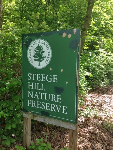
This weekend, February 11th & 12th, 2017, you’ll have two Springwater Trails (ST) hike event opportunities. The Sunday hike is a “travel hike” to Steege Hill in Big Flats, NY. There is also a ST “Bonus Hike Event” on Saturday in form of a Hike Combo Event in Penfield, NY, … which is the subject of the ‘event post’ you are reading (here and now). This Hike Combo Event in Penfield is also a “travel hike”, albeit a closer travel than is Steege Hill.
The Saturday 2/11/2017 ST hike starts at 1:00PM in Penfield, NY. There are two separate start points for the ST hike event!!! In fact there are two different parks, both in Penfield NY, which are holding the hike routes and start points for this ST hike event. One hike is described as strenuous, hilly, 5-6 miles in length at Lucien Morin Park (aka Rifle Range Trail & more trails), a hike for ST Climbers. (Mildly stated, it is highly likely you’ll want TDs for this hilly hike at this time of year, be it snow/ice/mud for trail conditions. See the further description about TDs below.) The other hike is described as easy, ~ 2 miles on mostly flat trails, a hike for ST Tourists & Naturalists. After-hike social to be held at MacGregor’s Grill & Tap Room at 1129 Empire Blvd, Penfield.
This ST Bonus Hike Combo Event is scheduled in Penfield so as to conveniently sync with the 6th Annual Hikers’ Jamboree (HJ2017), which is badged as an “Indoor Hike” event, organized by Penfield Trails Committee (PTC), scheduled for 10:00AM-12:00Noon at Penfield Town Hall Auditorium situate at 3100 Atlantic Avenue, Penfield, NY. Following HJ2017, two outdoor hikes are subsequently provided at 1:00PM at two separate parks in Penfield, both with some included history components. This years program presentation for HJ2017 is on the famed railroad high bridge (viaduct) situate in Letchworth State Park. The viaduct high above the Genesee River is 140+ years old and will soon be replaced by a new viaduct. You’ll learn much more about these two viaducts at the HJ 2017 viaduct program presentation which runs ~10:30-11:40am. Penfield Town Hall is located at 3100 Atlantic Av, Penfield NY; ~ GPS coords 43.160959 , -77.446125
(Of note, many ST hikers will recall a ST hike on Oct 13, 2013 in Letchworth State Park where all three hiking subgroups by chance were on the trail near the base of this 1875 railroad high bridge, when we all had chance opportunity to view a train pass overhead! Thanks go to superb arrangement by that day’s Hike Planners Joan & Bob for the rare experience.)
During HJ2017 light refreshments will be served, so you’ll have sustenance/fuel opportunity before availing of choice of two outdoor hike locations with an 1:00PM start time. For easy reference and more info, here is an Event post about Hikers’ Jamboree 2017 as published on the ST website.
⇓ TWO HIKES ⇓ Start times for both at 1:00PM.
Those ST hikers desiring a Climbers level hike, (which will finish ~ 3:15PM), will hike in Lucien Morin Park, an “undeveloped” Monroe County Park, located at 1135 Empire Blvd. Climbers, as a ST subgroup, will actually be “joining-in” a GVHC hike that is led by Ryan B. (A number of ST hikers are previously acquanted with Ryan from previous hikes & socialization.) The hike start is at the entrance to Lucien Morin Park (a Monroe County Parks System park), the park entrance is off Empire Blvd near the foot of Irondequoit Bay, and situate immediately east of MacGregor’s Grill & Tap Room Restaurant (1129 Empire Blvd).
This hike will be hilly and will be adjacent Irondequoit Creek in some areas, and will traverse areas that were used in World War reserve troop training, including rifle training and more. Remnants of training areas still remain suggesting some of the training that took place. The “lost city of Tryon” lies on the the east side of Irondequoit Creek as does Tryon Park, an undeveloped Monroe County Park. Tryon Park can be seen accros the creek at various places on this hike.
Parking at Lucien Morin Park: There is a parking lot for this park at the end of the rather short park entrance road (entrance road runs off Empire Blvd). You can see the parking lot from Empire Blvd. Additional parking if needed can be had at MacGregor’s Grill & Tap Room Restaurant parking lot, said parking lot is immediately adjacent the park’s parking lot and entrance road. Please be respectful of this business who allows hikers to utilize the lot for overflow parking, if needed please park as far back in this business’s parking lot as is possible.
Being Climbers subgroup is joining-in a GVHC hike, GVHC hike rules apply (which are quite similar to ST hike rules). Perhaps the most glaring difference of hike rules … on GVHC hikes DOGS ARE NOT ALLOWED! So, if you want to hike with your dog on today’s ST provided for hike, you’ll need to do so with the Tourists/Naturalists which is wholly a ST hike (ie – not a join-in with GVHC).
Note: Climbers should expect many more hikers at this hike than ST hikers usually experience at a hike. Lucien Morin Park hike route is hilly and can be strenuous for some, but hey, that’s what Climbers are all about.
Naturalists & Tourists will hike in Ellison Park as accessed via Blossom Rd (at the bottom of Blossom Rd hill, ~1809 Blossom Rd). Ellison Park is a Monroe County Parks System park. Start point for this hike is in the parking lot on the north side of Blossom Rd, … the parking lot at the bottom of Blossom Rd hill that is not the “Dog Park” parking lot but is slightly east of the Dog Park parking lot. Well behaved dogs accompanied by owners are allowed on this Ellison Park hike route, where Gene will be the ST Hike Leader.
This Ellison Park hike route is mostly a flat route for an easy hike, substantially paralleling two bifurcations of Irondequoit Creek, reaching a memorial marker of an Indian trading post and site of Fort Schuyler where a reproduction of the original fort structure is situate.
⇓ TRACTION DEVICES, A HIKER’S FRIEND ⇓
Given that it is winter season, Traction Devices (TDs) may be in order (read … probably an excellent idea) for each of these two hikes routes. Lucien Morin Park trails are hilly and under certain conditions can be strenuous sans TDs. TDs help to tame the hills when they are slippery with ice &/or mud. Ellison Park trail route can also be slippery albeit the trail route is mostly flat. TDs such as Kahtoola MICROspikes, Hillsound Trail Crampons, Hillsound Trail Crampons Ultra, and similar, may be desirable on Lucien Morin Park hills, and same type or lesser aggressive TDs may be good for Ellison Park.
If your best guess is there is no snow and/or ice if hike day’s temps are higher than average, well… that could equate to mud on the hills which equates to a need for added traction. (A side note, I have under similar conditions seen hikers quickly return to the start point due to lack of having TDs and the trail being beyond their best adjudged capabilities without them.)
Hug The Trees, Please! When wearing TDs with spikes/cleats & similar … please be kind to trees … whenever possible anticipate your footing placement on the trail and step over tree roots, not directly on them which can puncture and damage roots & ultimately health of those trees and on larger scale the forest and ecosystem. Think about it … If you were lying on the trail gazing at the sky would you rather have a group of hikers wearing sharp piercing TDs step on you, or, step over you or around you. Safe to say if hikers were NOT stepping on you you’d be unscathed by those sharp cleats and spikes of said passing hikers, but not so if alternatively they stepped on you with those sharp metal cleats & spikes.
⇓ DIRECTIONS TO HJ2017 AND THEN TO TWO SUBSEQUENT SEPARATE HIKES ⇓
Directions to PENFIELD TOWN HALL AUDITORIUM, 3100 Atlantic Ave aka NYS Rt 286. For Penfield Trails Committee’s (PTC) “Indoor Hike” aka Hikers’ Jamboree 2017 scheduled 10:00AM-12:00Noon. From points south of Rochester take expressway I-390 northbound, to expressway Rt 590 northbound, to exit for Browncroft Blvd / NYS Rt 286, head east on NYS Rt 286 which is also Browncroft Blvd and which will change names to Atlantic Avenue at the intersect with Whalen Rd & Scribner Rd 4-way intersection, continue on NYS RT 286 / Atlantic Avenue to just past Jackson Rd and then turn let into the Penfield Town Hall driveway.
⇓ Directions: to the two separate hike start locations (1:00PM hike), from Penfield Town Hall. ⇓
To LUCIEN MORIN PARK (1135 Empire Blvd) – NO DOGS ALLOWED on this hike: From Penfield Town Hall utilize Town Hall’s entrance/exit drive aka Columbus Crossing (westbound) to Jackson Rd and turn right onto Jackson Rd, proceed northbound on Jackson Rd to Plank Rd & turn Left, proceed on Plank Rd to Empire Blvd, turn left onto Empire Blvd and near the bottom of the Empire Blvd hill on the left you will find the entrance drive to Lucien Morin Park. (It is immediately adjacent MacGregor’s Grill & Tap Room Restaurant.)
To ELLISON PARK (~1809 Blossom Rd) – DOGS ARE ALLOWED on this hike: From Penfield Town Hall utilize the Town Hall’s Atlantic Av aka NYS Rt 286 entrance/exit drive, turn right heading westbound onto NYS RT 286 aka Atlantic Av, continue on NYS RT 286 / Atlantic Av westbound (realizing Atlantic Av will change names to Browncroft Blvd at the intersect with Whalen Rd & Scribner Rd 4-way intersection), continue on NYS RT 286 / Browncroft Blvd to the 4-way intersect with Creek St and Blossom Rd, turn left onto Blossom Rd and proceed on Blossom Rd down a winding hill to the Ellison Park parking lot on the right which is is slightly east of the Dog Park parking lot. (hints: There is a porta-potty at the far west side of this hike meet parking lot, and also a winter ice skaing rink immediately contiguous to the west side of this parking lot. Hike Meet point is about in the middle of this designated parking lot. If as you travel on Blossom Rd, you reach the dog Park parking lot, you went to far and have passed the designated hike meet parking lot.)
⇓ Directions: to the two separate hike start locations (1:00PM hike), from points south of Rochester. ⇓
Directions to LUCIEN MORIN PARK: – take expressway I-390 northbound, to expressway Rt 590 northbound, to the exit for NYS Rt 404 / Empire Blvd exit, head east NYS Rt 404 / Empire Blvd to the bottom of the hill / foot of Irondequoit Bay, Lucien Morin Park (1135 Empire Blvd) entrance road and parking lot is immediately east of MacGregors Grill & Tap Room Restaurant at 1129 Empire Blvd.
Directions to ELLISON PARK: – take expressway I-390 northbound, to expressway Rt 590 northbound, to Blossom Rd exit, head east on Blossom Rd to the bottom of the hill, where Ellison Park will then be on both sides of Blossom Rd. Ellison Park parking lot for this hike is on the north side of Blossom Rd (a left turn into the lot), further described as the parking lot at the bottom of Blossom Rd hill that is not the “Dog Park” parking lot but is slightly east of the Dog Park parking lot. (If you reach “Gatherings Catering” Company – at “Daisy Flour Mill” Party House / Restaurant, situate in the circa 1840 Daisy Flour Mill building, on the right side of Blossom Rd, you’ve gone too far.)
AFTER-HIKE SOCIAL & ⇓ Directions thereto ⇓: After-hike social is at MacGregor’s Grill & Tap Room Restaurant [phone=288-8630] located at 1129 Empire Blvd next to Lucien Morin Park. So Climbers will merely walk nextdoor from the hike end portal to MacGregor’s.
Naturalists/Tourists will need to drive to the social. From Ellison Park on Blossom Rd head east up a long winding hill, at the 4-way intersection of Blossom Rd & Creek St (where Browncroft Blvd aka Rt 286 intersects) continue straight onto Creek St, at Plank Rd turn left, at Empire Blvd turn left, at the bottom of Empire Blvd hill & the foot of Irondequoit Bay will be MacGregor’s of the left.
Springwater Trails (ST) and Genesee Valley Hiking Club (GVHC aka GVHG) both provide their hikes as open to the general public, no need to be a respective member to hike with either group. Hike rules as set by respective groups and Hike Leaders apply.
Located in Chemung County in the town of Big Flats, Steege Hil is a 794 acre preserve acquired in 2001 by the Finger Lakes Land Trust from an anonymous donor. In 1970, this area was nearly ruined by heavy logging. The Town of Big Flats took action to stop the degradation on the hill by shutting down the operation and passing a law regulating future logging within town limits. Now the original forest is making an impressive recovery. Numerous species of hardwoods prevail, mixed with conifers on the steeper slopes. Wildlife include black bear, timber rattle snakes, and Allegheny Mound Ants. Their distinctive nests can be found trail side and in open areas. For additional information and maps go to http://fllt.org/preserves/steege-hill-preserve
Steward, Bob Corneau has maintained a network of more than 6 miles of trails, mostly over old logging roads. It is our good fortune to be able to enjoy the quiet beauty of these tails on a winter afternoon, Check the Springwater Trails website on February 11 for an update on trail conditions. If there is snow we could ski or snowshoe.
Parking in very limited at this preserve so car pooling is strongly encouraged.
Hike Description
All groups will depart from the parking area on Steege Hill Rd. After a short but steep ascent, our groups will branch out as follows:
Naturalists will follow the yellow loop in a clockwise direction, enjoying some gentler terrain as well as views of the Chemung River and ponds. The ant mounds are numerous on this trail. Out nature experts will no doubt enjoy identifying the many varieties of trees and birds. Hike length will be about 2.5 miles.
Tourists will head our on the yellow loop in a counter clockwise direction, past the ponds and then onto the blue trail to loop through the forest back to the yellow trail. Views of the valley as well as the lower slopes should be nice. Hiking distance about 3.5 miles.
Climbers An ambitious journey awaits you, a complete circuit of the trail system.. This group will veer off from the initial climb to follow the white trail, traversing some significant ups and downs. They will sample the blue and red trails (more hills) before returning home on the yellow loop for about 5 miles. It’s all down hill on the return.
After Hike Social will be at Tag’s Restaurant on Rte, 352 in Big Flats.
Getting There Parking is VERY LIMITED. Roadside parking is not advisable. Please carpool from the Springwater Town Hall, leaving at 12:30. Drive time is about 1 hour 15 minutes.
 Directions: Take 390 South to I 86 East. Take Exit # 48. Turn Right on NY 352. Go 1.5 miles. Turn right on S. Corning Rd. (Chemung CR 10). Go .7 miles. Just after bridge turn left on Steege Hill Rd. Go 1 mile. Slow down. Parking is on left. Preserve sign is difficult to spot.
Social There is a great little joint called Tags, recommended by local folks. To get there, retrace your steps back to Rte 352. Turn right and travel about 0.6 mile. Restaurant is on the right. Menu is full of salads, burgers, wraps and apps. See it at tagsrestaurant.com
Trail conditions Update 2/11/17. Looks like freezing rain tonight and rain tomorrow. Best bet is to wear waterproof clothing and bring traction control devices/ hiking poles in case conditions are slippery.
Looking for brochure.or mailing list so I can receive it in the mail.
Nothing opens up for mailing list.
There’s all kinds of very bizarre ads and post for viagra and other drugs above on calender page.
Please let me know if there’s a brochure available