
Hikes led by Springwater Trails are generally held on Sunday afternoons and appear in this calendar in green.
| Sun | Mon | Tue | Wed | Thu | Fri | Sat |
|---|---|---|---|---|---|---|
| A Comprehensive Plan Workshop for our Town of Springwater 9:00 am A Comprehensive Plan Workshop for our Town of Springwater @ Springwater Fire Department May 2 @ 9:00 am – 12:00 pm All Residents of the Town of Springwater are strongly urged to take part in this workshop. You will learn . . . What a Comprehensive Plan really is Why Springwater needs one Your participation, as citizens of Springwater, is … Continue reading | ||||||
| Letchworth’s #1 STATE PARK Celebration 1:00 pm Letchworth’s #1 STATE PARK Celebration @ Letchworth State Park May 3 @ 1:00 pm – 4:00 pm  Come celebrate with Letchworth State Park on Sunday May 3rd from 1 to 4 pm, to honor all the park’s patrons and supporters for voting to help the park win a recent national poll as the #1 State Park in the … Continue reading GRIMES GLEN NAPLES LOOP 2:00 pm GRIMES GLEN NAPLES LOOP @ GRIMES GLEN PARKING LOT May 3 @ 2:00 pm – 4:00 pm 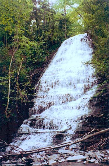 The Finger Lakes Trail has a main trail, branch trails and loop trails. This Sunday’s hike will be in and around the Village of Naples on sections of the newest loop trail. Soon to be blazed with purple discs, the Grimes … Continue reading | NYFOA WFL chapter hosts Game of Logging NYFOA WFL chapter hosts Game of Logging May 9 all-day The Western Finger Lakes chapter of NYFOA is partnering with the New York Center for Agricultural Medicine and Health (NYCAMH) to offer a Game of Logging Level 1 class on 09 May at Pete Muench’s property in Naples. The Game … Continue reading Ontario Pathways – Seven Saturday Hikes, one each month 9:30 am Ontario Pathways – Seven Saturday Hikes, one each month May 9 @ 9:30 am – 11:00 am Meet at the designated locations by 9:30. April 25th. Meet at the New Covenant Baptist Church Parking lot on County Road 46. Hike Main St to CR 46. (3mi) May 9th. Meet at the New Covenant Baptist Church Parking lot … Continue reading | |||||
| Mossy Bank Park, Bath 2:00 pm Mossy Bank Park, Bath @ Mossy Bank Park, in front of nature center May 10 @ 2:00 pm – 4:00 pm 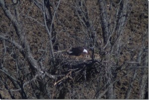 Get your favorite mother and bring her to our Mother’s Day celebration at a new location for our group. Mossy Bank Park is located on a hill south of Bath, overlooking the valley and city. We will be greeted by … Continue reading | Ontario Pathways – Seven hikes on seven Tuesdays 10:00 am Ontario Pathways – Seven hikes on seven Tuesdays May 12 @ 10:00 am – 12:00 pm Meet at the designated locations by 10:00am. May 12th. Meet at Gifford Rd. Hike to Wayne county line and back (3.6mi) May 19th. Meet at Rt 96 trail head. Hike Rt 96 to Wheat Rd (3.8mi) May 26th. Meet at … Continue reading | |||||
| White Brook Nature Area 2:00 pm White Brook Nature Area @ Crescent Trail May 17 @ 2:00 pm – 4:00 pm This Sunday’s excursion will bring us to the wilds of Egypt (NY that is). We will explore the White Brook Nature Area and the Thayer Hill section of the Crescent Trail. There we will find an assortment of terrain, wetlands, … Continue reading | Ontario Pathways – Seven hikes on seven Tuesdays 10:00 am Ontario Pathways – Seven hikes on seven Tuesdays May 19 @ 10:00 am – 12:00 pm Meet at the designated locations by 10:00am. May 12th. Meet at Gifford Rd. Hike to Wayne county line and back (3.6mi) May 19th. Meet at Rt 96 trail head. Hike Rt 96 to Wheat Rd (3.8mi) May 26th. Meet at … Continue reading | |||||
| Gardner Road 2:00 pm Gardner Road @ North Cohocton May 24 @ 2:00 pm – 4:00 pm This weekend we will be hiking a series of logging roads along a side hill over looking the hamlet of North Cohocton. We will start up a trail off of Gardner Rd. starting with a small moderate climb and then … Continue reading | Ontario Pathways – Seven hikes on seven Tuesdays 10:00 am Ontario Pathways – Seven hikes on seven Tuesdays May 26 @ 10:00 am – 12:00 pm Meet at the designated locations by 10:00am. May 12th. Meet at Gifford Rd. Hike to Wayne county line and back (3.6mi) May 19th. Meet at Rt 96 trail head. Hike Rt 96 to Wheat Rd (3.8mi) May 26th. Meet at … Continue reading | |||||
This Sunday’s excursion will bring us to the wilds of Egypt (NY that is). We will explore the White Brook Nature Area and the Thayer Hill section of the Crescent Trail. There we will find an assortment of terrain, wetlands, ponds, streams, a small woodland, all on the fringe of suburbia. We will meet at the parking area/park of the White Brook Nature Area.
Here is the plan for our three levels of hiking. Maps will be provided to hike leaders and are also available on the Crescent Trail website. My apologies for lack of photo preview. My camera was left behind when I went on the pre-hike. Trust me it is a beauty of a trail.
Naturalists will be anxious to amble through the fields on the main trail (orange) which is flat and open with some board walks. Depending on the weather this week, it may be wet and muddy in spots. There are options depending on the wishes of the group. The trail makes a 2 mile loop to return to the parking area, or can continue on towards the Erie Canal. Because it is an open area, sun screen and tick protection is advisable. I hope to enlist a volunteer to lead this group.
Tourists Will head west across Aldrich Road from the parking area to follow a section of the Crescent Trail (orange to a blue loop) through a woods of lovely wildflowers, on past ponds with some great blue herons dropping in and out. The end section of this segment is closed due to construction so it is necessary to return by the same route to avoid a road walk on Rte 31. This trail is only about 3 miles in length so the group can hike the Naturalist section upon return if desired. A hike leader is needed for this group also.
Climbers who are up for a challenge, can carpool down the road a ways to the Thayer Hill / Indian Hill section of the Crescent Trail for a loop of approximately 4 miles of ups and downs through woods and fields with some nice views of the surrounding area and the Rochester skyline. Note that there is some poison ivy along the sides of the trail, so dress accordingly. Melissa will lead this group.
Driving Directions From route 5/20 in Bloomfield, head north on Rt 444 to the village of Victor. Turn right on Rt 96 north, then take the first left (north) on Church St., which becomes County Rd 9. Follow CR 9 north to Rt 31 (Pittsford Palmyra Rd.). Go east on Rt 31 for a short distance, then turn north on Aldrich Rd. White Brook Nature Area is about .5 miles on the right. There is a gate and a sign. Plenty of parking and rest rooms.
After Hike Social will be at Noonan’s Pub, 7408 Pittsford-Palmyra Rd., Fairport, about 1.5 miles west of White Brook. See their website for menu
Meet at the designated locations by 10:00am.
May 12th. Meet at Gifford Rd. Hike to Wayne county line and back (3.6mi)
May 19th. Meet at Rt 96 trail head. Hike Rt 96 to Wheat Rd (3.8mi)
May 26th. Meet at the Orleans water tower. Hike Orleans to Boces (4.5mi)
June 2nd. Meet at BOCES parking lot. Hike Boces to Stanley Junction (3.5mi)
June 9th. Meet at Depot Road. Hike Stanley Junction back to Depot Rd (3.8mi)
June 16th. Meet at the New Covenant Baptist Church Parking lot on County Road 46. Hike Depot Road back to CR 46. (5mi)
June 23rd. Meet at the Ontario Street parking lot. Hike County Road 46 back to Main St. (3mi)
You can download a PDF with more information.
This weekend we will be hiking a series of logging roads along a side hill over looking the hamlet of North Cohocton. We will start up a trail off of Gardner Rd. starting with a small moderate climb and then a flat trail for about a mile.
We will turn up the hill on another logging road that winds up the gully and comes out in a meadow half way up the hill. We will follow a trail along side the meadow and through some hardwood forest where we will start acending back down the hill to the trail we came in on.
After the hike, we will have our social at the Mountain View Inn Located in Atlanta.
Directions:
From Wayland: head east on RT 21 for about 5 miles. Gardner Rd. is on the left. Drive up Gardner Rd. for about 1 mile. The trail starts on the left across the road from a mobile home that sits on the right hand side.
From Honeoye: Drive south on RT 36, turn right onto French Hill Road and drive until it changes to Atlanta/Garling House Road. Take Atlanta Garling House Road south until you pass Schummacker Farms. turn right onto Pardee Hollow and follow it for another mile and turn left onto Gardner Road. about 1 mile up Gardner Road is were the hike starts.
To get to the Mountain View Grill, take Gardner back out to RT 21 turn left and travel east for about a mile there will be a sign on the right that points to Atlanta. Take this road to the end and turn right. The Mountain View is down the road about 500ft on the right.
Meet at the designated locations by 10:00am.
May 12th. Meet at Gifford Rd. Hike to Wayne county line and back (3.6mi)
May 19th. Meet at Rt 96 trail head. Hike Rt 96 to Wheat Rd (3.8mi)
May 26th. Meet at the Orleans water tower. Hike Orleans to Boces (4.5mi)
June 2nd. Meet at BOCES parking lot. Hike Boces to Stanley Junction (3.5mi)
June 9th. Meet at Depot Road. Hike Stanley Junction back to Depot Rd (3.8mi)
June 16th. Meet at the New Covenant Baptist Church Parking lot on County Road 46. Hike Depot Road back to CR 46. (5mi)
June 23rd. Meet at the Ontario Street parking lot. Hike County Road 46 back to Main St. (3mi)
You can download a PDF with more information.
Meet at the designated locations by 9:30.
April 25th. Meet at the New Covenant Baptist Church Parking lot on County Road 46. Hike Main St to CR 46. (3mi)
May 9th. Meet at the New Covenant Baptist Church Parking lot on County Road 46. Hike CR 46. to Depot Road (5mi)
June 6th. Meet at Depot Road. Hike Depot Rd to Stanley Junction (3.8mi)
July 11th. Meet at BOCES parking lot. Hike Stanley Junction to Boces (3.5mi)
August 15th. Meet at the Orleans water tower. Hike Boces to Orleans (4.5mi)
September 12th. Meet at Rt 96 trail head. Hike Wheat Rd to Rt 96 (3.8mi)
October 10th. Meet at Gifford Rd. Hike to Wayne county line and back (3.6mi)
You can download a PDF with more information.
Lets try again! But rain is predicted so check here on Sunday
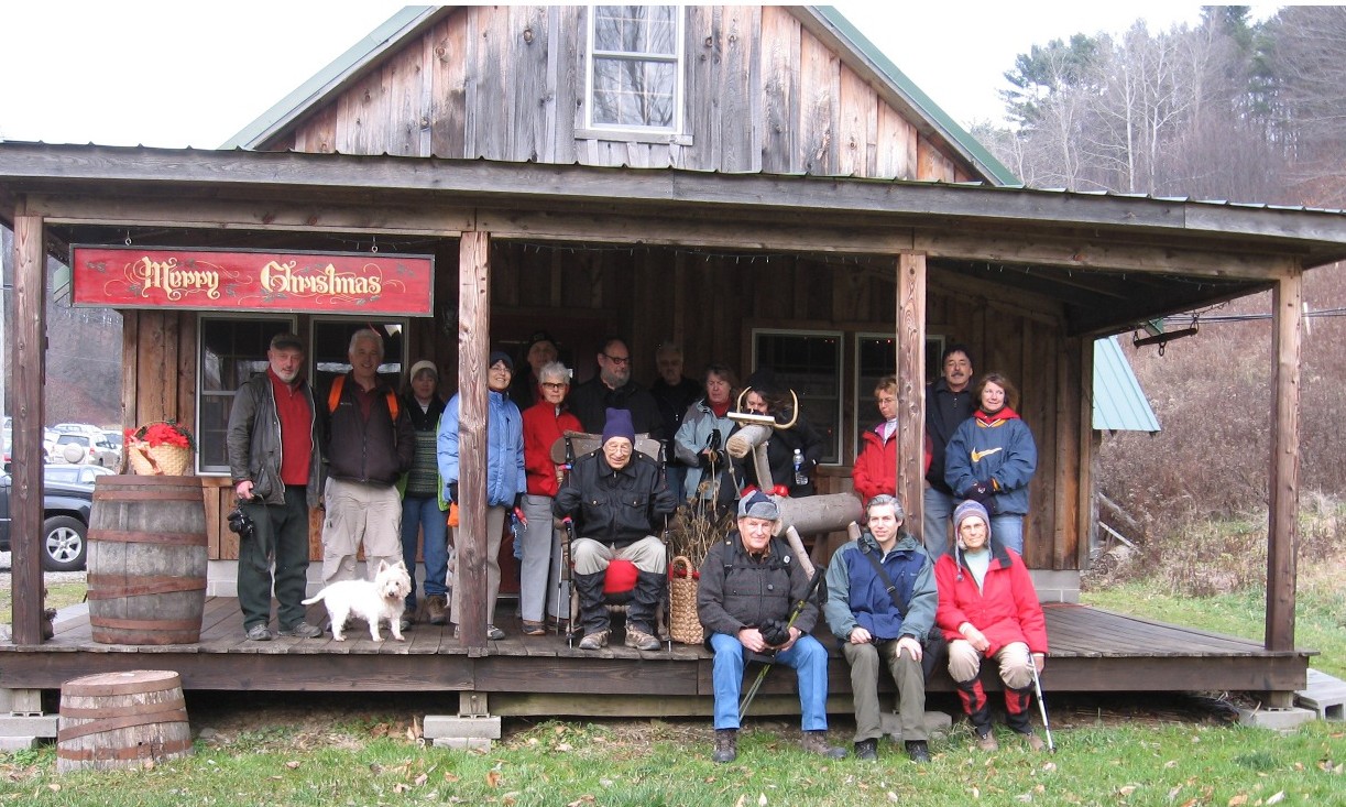 Every year, our organization devotes a few of our Sundays to keeping the trails we love to hike on, in good hiking condition. This Sunday, we’re going to a section that the late Chuck Winship, one of the founders of our hiking group, dedicated a portion of his then thriving maple farm, as the start of a scenic public hiking trail through Springwater.
During the summertime, we have moved our hike starting time up to 4 PM, to avoid the mid day heat, when only mad dogs and Englishmen venture forth. This change in time begins today. We will meet, at 4 PM, at the Sugarhouse on Pardee Hollow Rd. Bring work gloves and loppers. If you can bring a string trimmer, we could use two or three. A couple of small saws be available for larger branches.
In our 2 hour work period, we hope to cover the main trail, between Coates Rd. and Pardee Hollow, the seasonal access, the trillium side trail and,the steep extension between Pardee Hollow and Tabors Corners as well as the more level bypass. We will split into several groups to ensure we get as much done as possible.
It has been our policy to provide a substantial dinner to those who participate in these trail work jobs. We will do this at the small field in front of the Sugar House. You need to bring a lawn chair, but no food this time (beverages might come in handy though).
Directions to the Sugarhouse are just one click away!
Meet at the designated locations by 10:00am.
June 9th. Meet at Depot Road. Hike Stanley Junction back to Depot Rd (3.8mi)
You can download a PDF with more information.
Canceled: At 2:20, the forecast has gotten more definite for thunderstorms. So we have canceled the hike for today. Please join us next Sunday.
Notice: As of 1:30 Sunday, wunderground predicts 80% chance of thunderstorms in Geneseo. Although we aren’t cancelling the hike until we see the weather at 4:00, please know that we will cancel if there is lightning at 4:00 and we will abort if the lightning starts during the hike. Pati has also scoped out a couple of shelters for the social if it raining at the end of the hike. Hope to see you at four
A year ago last March our group enjoyed this hike despite the cold and muddy conditions. The weather predictions for this Sunday look sunny and warm. With the rain this week expect some mud, but for the most part a pleasant hike and great company. We will meet at 4:00 at the Preserve Kiosk on Jones Bridge Rd and Rt63.
History of the area
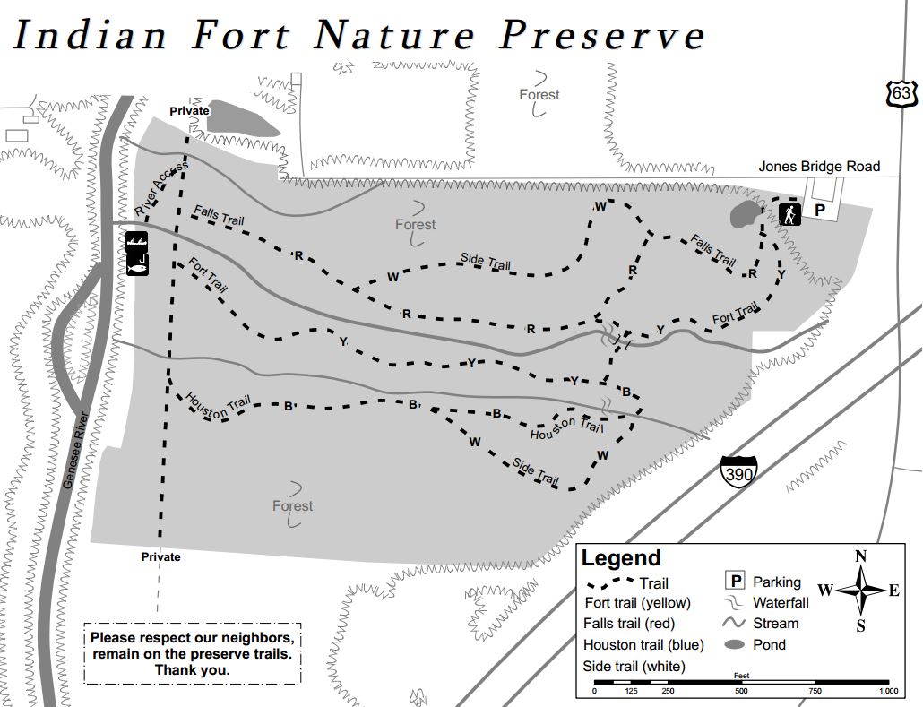
Indian Fort Nature Preserve (42.766,-77.8295) is managed and maintained by Genesee Valley Conservancy. It is known as “Indian Fort” because of the two palisades that once stood on the site. Two mounds are still visible where the wooden posts created a fenced enclosure between the two main gullies. These palisades date back to 1400 – 1500 A.D. The former Iroquois palisades prompted the area to be listed on the National Register of Historic Places in 1974. Because of the diverse botanical, cultural and geological features, the preserve has been designated a Research Reserve by the conservancy.
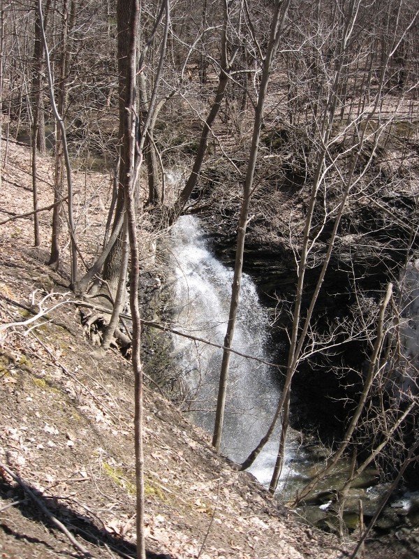
Upper falls
The property consists of sixty acres with gullies, creeks, a small field, a pond, and access to the Genesee River. Trails are well marked and go from the parking area on the northeast side of the preserve through the preserve to the Genesee River. Two waterfalls can be seen from the trails.
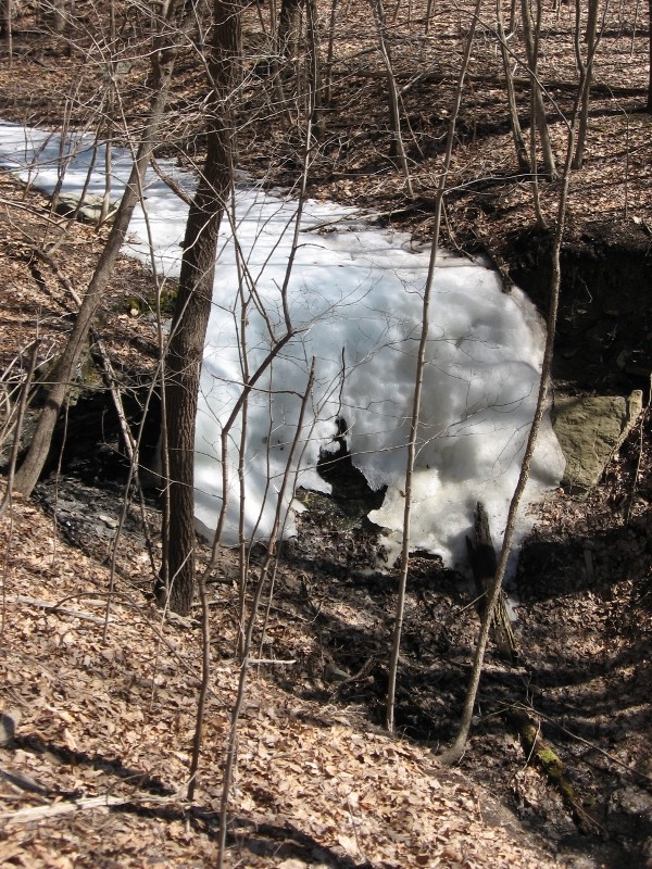
Snowfalls
Our Hikes
Climbers will not find the main trails a challenge, but they can travel up the gullies to the waterfalls and climb the steep sides of the gullies. Tourists can follow the climbers and scale the gully walls before they get too steep. naturalists will find easy hiking on trails that have slight hills and a lot of flat land.
The Social
The hike will be followed by a tailgate social in the parking lot. Bring a dish to pass and your own beverage or make a contribution to the social fund. Bring a chair is you choose to rest your bones.
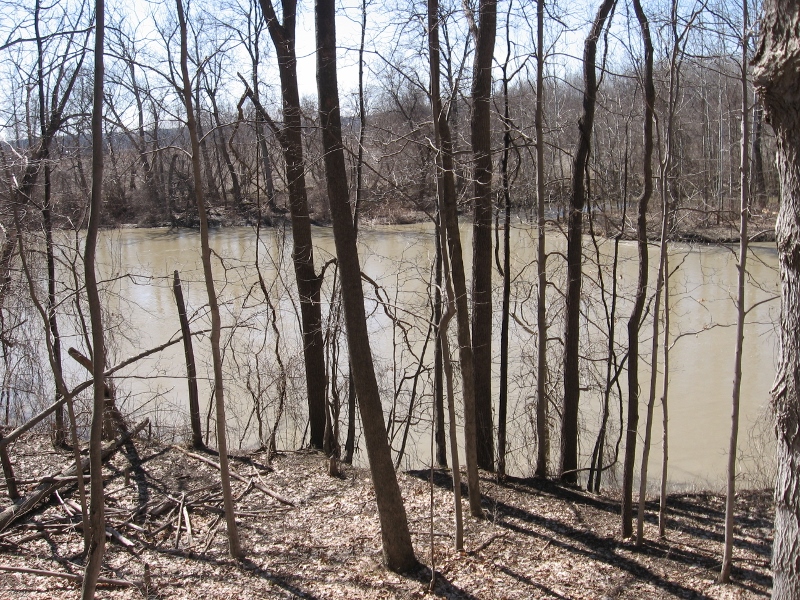
The Genesee River
Dogs are allowed on a leash or ‘controlled’ by verbal commands. Please note that some parts of the trails are in close proximity to busy route 63.
Directions
The preserve is located at 3432 Jones Bridge Road. There is no sign identifying this branch of Jones Bridge Road. Please note: Jones Bridge Road has three sections separated by the Genesee River and by I-390. The preserve is on the small section west of I-390 and east of the Genesee River.
From Springwater: There are many options from Springwater including taking I 390N from Wayland to Mt Morris (see below). The route with the fewest turns takes Rt 15 N out of Springwater for 1.5 miles. Turn left onto Liberty Pole Rd (CR 38) and follow that road for 8.1 miles (it will change names and CR numbers two times) to NY-63. Turn right and follow NY 63 for 8.3 miles (there is a right turn staying on NY 63 [Mt Morris-Geneseo Rd] after 6.4mi). The Preserve is on the left and the kiosk can be seen from the road.
From Mt. Morris exit of Rt 390: North on Rt. 408, which becomes Rt. 63. Stay on Rt. 63 for 2 miles. The Preserve is on the left and the kiosk can be seen from the road.
From Geneseo: Head south on Rt. 39/Rt. 20A. At the traffic light where Routes 20A and 39 turn to the right, continue south on Rt. 63 for 1.2 mile. The preserve is on the right and the kiosk can be seen from the road.
From Rochester: Head south on I 390 S to Exit 8. Turn right onto US 20A for 4.9 miles. Turn right onto Mt Morris Rd (20A and 39S). At the traffic light where Routes 20A and 39 turn to the right, continue south on Rt. 63 for 1.2 mile. The preserve is on the right and the kiosk can be seen from the road.
From Honeoye: Follow Rt 20A west to Geneseo. Turn right onto Mt Morris Rd (20A and 39S). At the traffic light where Routes 20A and 39 turn to the right, continue south on Rt. 63 for 1.2 mile. The preserve is on the right.
Looking for brochure.or mailing list so I can receive it in the mail.
Nothing opens up for mailing list.
There’s all kinds of very bizarre ads and post for viagra and other drugs above on calender page.
Please let me know if there’s a brochure available