
Hikes led by Springwater Trails are generally held on Sunday afternoons and appear in this calendar in green.
| Sun | Mon | Tue | Wed | Thu | Fri | Sat |
|---|---|---|---|---|---|---|
| A Comprehensive Plan Workshop for our Town of Springwater 9:00 am A Comprehensive Plan Workshop for our Town of Springwater @ Springwater Fire Department May 2 @ 9:00 am – 12:00 pm All Residents of the Town of Springwater are strongly urged to take part in this workshop. You will learn . . . What a Comprehensive Plan really is Why Springwater needs one Your participation, as citizens of Springwater, is … Continue reading | ||||||
| Letchworth’s #1 STATE PARK Celebration 1:00 pm Letchworth’s #1 STATE PARK Celebration @ Letchworth State Park May 3 @ 1:00 pm – 4:00 pm  Come celebrate with Letchworth State Park on Sunday May 3rd from 1 to 4 pm, to honor all the park’s patrons and supporters for voting to help the park win a recent national poll as the #1 State Park in the … Continue reading GRIMES GLEN NAPLES LOOP 2:00 pm GRIMES GLEN NAPLES LOOP @ GRIMES GLEN PARKING LOT May 3 @ 2:00 pm – 4:00 pm 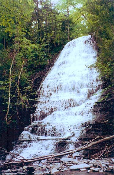 The Finger Lakes Trail has a main trail, branch trails and loop trails. This Sunday’s hike will be in and around the Village of Naples on sections of the newest loop trail. Soon to be blazed with purple discs, the Grimes … Continue reading | NYFOA WFL chapter hosts Game of Logging NYFOA WFL chapter hosts Game of Logging May 9 all-day The Western Finger Lakes chapter of NYFOA is partnering with the New York Center for Agricultural Medicine and Health (NYCAMH) to offer a Game of Logging Level 1 class on 09 May at Pete Muench’s property in Naples. The Game … Continue reading Ontario Pathways – Seven Saturday Hikes, one each month 9:30 am Ontario Pathways – Seven Saturday Hikes, one each month May 9 @ 9:30 am – 11:00 am Meet at the designated locations by 9:30. April 25th. Meet at the New Covenant Baptist Church Parking lot on County Road 46. Hike Main St to CR 46. (3mi) May 9th. Meet at the New Covenant Baptist Church Parking lot … Continue reading | |||||
| Mossy Bank Park, Bath 2:00 pm Mossy Bank Park, Bath @ Mossy Bank Park, in front of nature center May 10 @ 2:00 pm – 4:00 pm 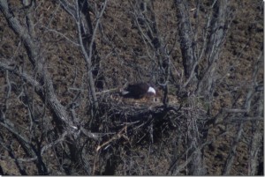 Get your favorite mother and bring her to our Mother’s Day celebration at a new location for our group. Mossy Bank Park is located on a hill south of Bath, overlooking the valley and city. We will be greeted by … Continue reading | Ontario Pathways – Seven hikes on seven Tuesdays 10:00 am Ontario Pathways – Seven hikes on seven Tuesdays May 12 @ 10:00 am – 12:00 pm Meet at the designated locations by 10:00am. May 12th. Meet at Gifford Rd. Hike to Wayne county line and back (3.6mi) May 19th. Meet at Rt 96 trail head. Hike Rt 96 to Wheat Rd (3.8mi) May 26th. Meet at … Continue reading | |||||
| White Brook Nature Area 2:00 pm White Brook Nature Area @ Crescent Trail May 17 @ 2:00 pm – 4:00 pm This Sunday’s excursion will bring us to the wilds of Egypt (NY that is). We will explore the White Brook Nature Area and the Thayer Hill section of the Crescent Trail. There we will find an assortment of terrain, wetlands, … Continue reading | Ontario Pathways – Seven hikes on seven Tuesdays 10:00 am Ontario Pathways – Seven hikes on seven Tuesdays May 19 @ 10:00 am – 12:00 pm Meet at the designated locations by 10:00am. May 12th. Meet at Gifford Rd. Hike to Wayne county line and back (3.6mi) May 19th. Meet at Rt 96 trail head. Hike Rt 96 to Wheat Rd (3.8mi) May 26th. Meet at … Continue reading | |||||
| Gardner Road 2:00 pm Gardner Road @ North Cohocton May 24 @ 2:00 pm – 4:00 pm This weekend we will be hiking a series of logging roads along a side hill over looking the hamlet of North Cohocton. We will start up a trail off of Gardner Rd. starting with a small moderate climb and then … Continue reading | Ontario Pathways – Seven hikes on seven Tuesdays 10:00 am Ontario Pathways – Seven hikes on seven Tuesdays May 26 @ 10:00 am – 12:00 pm Meet at the designated locations by 10:00am. May 12th. Meet at Gifford Rd. Hike to Wayne county line and back (3.6mi) May 19th. Meet at Rt 96 trail head. Hike Rt 96 to Wheat Rd (3.8mi) May 26th. Meet at … Continue reading | |||||
The Western Finger Lakes chapter of NYFOA is partnering with the New York Center for Agricultural Medicine and Health (NYCAMH) to offer a Game of Logging Level 1 class on 09 May at Pete Muench’s property in Naples.
The Game of Logging is the premier training for chainsaw safety. Level 1 covers basic chainsaw sharpening and maintenance and felling trees. It is open to participants of any skill level, from those who have never used a chainsaw to those who want to learn a better and safer way to cut trees. Each class is limited to 10 participants and by the end of the day each participant will cut down a tree.
NYCAMH has received funding to subsidize this class, so the cost to register is only $25.
NYCAMH is sponsoring other classes around the state. These classes are open to anybody, so if you can’t make it to the one on 09 May you can register for one of the others.
To register, or for more information about any of these classes, call Erica Scott of NYCAMH at 800 343 7527 x2213.
Meet at the designated locations by 9:30.
April 25th. Meet at the New Covenant Baptist Church Parking lot on County Road 46. Hike Main St to CR 46. (3mi)
May 9th. Meet at the New Covenant Baptist Church Parking lot on County Road 46. Hike CR 46. to Depot Road (5mi)
June 6th. Meet at Depot Road. Hike Depot Rd to Stanley Junction (3.8mi)
July 11th. Meet at BOCES parking lot. Hike Stanley Junction to Boces (3.5mi)
August 15th. Meet at the Orleans water tower. Hike Boces to Orleans (4.5mi)
September 12th. Meet at Rt 96 trail head. Hike Wheat Rd to Rt 96 (3.8mi)
October 10th. Meet at Gifford Rd. Hike to Wayne county line and back (3.6mi)
You can download a PDF with more information.
Get your favorite mother and bring her to our Mother’s Day celebration at a new location for our group. Mossy Bank Park is located on a hill south of Bath, overlooking the valley and city. We will be greeted by our guest leader, Dr. Randy Weidner, a retired general practicioner and extraordinarily knowledgable amateur naturalist. Many of you met Randy when he came to our mushroom hike at Katherine’s and identified the mushrooms we collected.
We will meet at the nature center cottage and go inside for a brief look at the facility. Then, we will walk along the overlook road, where you will see a great view of the City of Bath and the valley below. Have your camera handy for this one.

The Mossy Bank Park eagle feeding her chicks
May 2, 2015
– by Brenda Todd
After this, we will be treated to a once in a lifetime sight. On a tree top, in the valley below, a pair of bald eagles have built a nest. From the overlook, we can see the nest from above. By the time we go there, the eggs will probably have hatched, and we’ll be able to see the chicks in the nest. Bring binoculars. After viewing the nest, we will hike the trails. There will be at least 2 hikes, a long one and short one, and Randy will probably lead the long one.
The social will be a Mother’s Day picnic at the pavillion in the park, near where we started. Bring a dish to pass, or make a donation. Restroom facilities are available.
Visit the park web site, to read about the park. Select “location” for detailed directions.
Directions:
From Wayland, go south on SR 21, under the viaduct, and turn left onto 390. After exit 1 (Avoca), merge onto 86. Take exit 38 and turn left, towards Bath. After passing 86, turn right on Morris St. Go past Tops. Stay right at the fork; go past the library. Right on Cameron St. Over Cohocton River. Continue about 1.6 mi. Watch for small Mossy Bank Park signs. Fork to the left onto Windfall Rd. Go about 0.4 mi. Left onto Mossy Bank Park Rd. Go 1.3 mi. to gate, marked with a small sign. Continue straight ahead until you pass between 2 large boulders into the park.
If you would like to car pool, or follow me there in your own car, go to the light in Wayland at the corner of Naples and Lackawanna Sts. Go west on Naples and turn right, after the 7-11 store. Park in the large lot behind the fire station. Be there no later than 1 PM.
Meet at the designated locations by 10:00am.
May 12th. Meet at Gifford Rd. Hike to Wayne county line and back (3.6mi)
May 19th. Meet at Rt 96 trail head. Hike Rt 96 to Wheat Rd (3.8mi)
May 26th. Meet at the Orleans water tower. Hike Orleans to Boces (4.5mi)
June 2nd. Meet at BOCES parking lot. Hike Boces to Stanley Junction (3.5mi)
June 9th. Meet at Depot Road. Hike Stanley Junction back to Depot Rd (3.8mi)
June 16th. Meet at the New Covenant Baptist Church Parking lot on County Road 46. Hike Depot Road back to CR 46. (5mi)
June 23rd. Meet at the Ontario Street parking lot. Hike County Road 46 back to Main St. (3mi)
You can download a PDF with more information.
This Sunday’s excursion will bring us to the wilds of Egypt (NY that is). We will explore the White Brook Nature Area and the Thayer Hill section of the Crescent Trail. There we will find an assortment of terrain, wetlands, ponds, streams, a small woodland, all on the fringe of suburbia. We will meet at the parking area/park of the White Brook Nature Area.
Here is the plan for our three levels of hiking. Maps will be provided to hike leaders and are also available on the Crescent Trail website. My apologies for lack of photo preview. My camera was left behind when I went on the pre-hike. Trust me it is a beauty of a trail.
Naturalists will be anxious to amble through the fields on the main trail (orange) which is flat and open with some board walks. Depending on the weather this week, it may be wet and muddy in spots. There are options depending on the wishes of the group. The trail makes a 2 mile loop to return to the parking area, or can continue on towards the Erie Canal. Because it is an open area, sun screen and tick protection is advisable. I hope to enlist a volunteer to lead this group.
Tourists Will head west across Aldrich Road from the parking area to follow a section of the Crescent Trail (orange to a blue loop) through a woods of lovely wildflowers, on past ponds with some great blue herons dropping in and out. The end section of this segment is closed due to construction so it is necessary to return by the same route to avoid a road walk on Rte 31. This trail is only about 3 miles in length so the group can hike the Naturalist section upon return if desired. A hike leader is needed for this group also.
Climbers who are up for a challenge, can carpool down the road a ways to the Thayer Hill / Indian Hill section of the Crescent Trail for a loop of approximately 4 miles of ups and downs through woods and fields with some nice views of the surrounding area and the Rochester skyline. Note that there is some poison ivy along the sides of the trail, so dress accordingly. Melissa will lead this group.
Driving Directions From route 5/20 in Bloomfield, head north on Rt 444 to the village of Victor. Turn right on Rt 96 north, then take the first left (north) on Church St., which becomes County Rd 9. Follow CR 9 north to Rt 31 (Pittsford Palmyra Rd.). Go east on Rt 31 for a short distance, then turn north on Aldrich Rd. White Brook Nature Area is about .5 miles on the right. There is a gate and a sign. Plenty of parking and rest rooms.
After Hike Social will be at Noonan’s Pub, 7408 Pittsford-Palmyra Rd., Fairport, about 1.5 miles west of White Brook. See their website for menu
Meet at the designated locations by 10:00am.
May 12th. Meet at Gifford Rd. Hike to Wayne county line and back (3.6mi)
May 19th. Meet at Rt 96 trail head. Hike Rt 96 to Wheat Rd (3.8mi)
May 26th. Meet at the Orleans water tower. Hike Orleans to Boces (4.5mi)
June 2nd. Meet at BOCES parking lot. Hike Boces to Stanley Junction (3.5mi)
June 9th. Meet at Depot Road. Hike Stanley Junction back to Depot Rd (3.8mi)
June 16th. Meet at the New Covenant Baptist Church Parking lot on County Road 46. Hike Depot Road back to CR 46. (5mi)
June 23rd. Meet at the Ontario Street parking lot. Hike County Road 46 back to Main St. (3mi)
You can download a PDF with more information.
This weekend we will be hiking a series of logging roads along a side hill over looking the hamlet of North Cohocton. We will start up a trail off of Gardner Rd. starting with a small moderate climb and then a flat trail for about a mile.
We will turn up the hill on another logging road that winds up the gully and comes out in a meadow half way up the hill. We will follow a trail along side the meadow and through some hardwood forest where we will start acending back down the hill to the trail we came in on.
After the hike, we will have our social at the Mountain View Inn Located in Atlanta.
Directions:
From Wayland: head east on RT 21 for about 5 miles. Gardner Rd. is on the left. Drive up Gardner Rd. for about 1 mile. The trail starts on the left across the road from a mobile home that sits on the right hand side.
From Honeoye: Drive south on RT 36, turn right onto French Hill Road and drive until it changes to Atlanta/Garling House Road. Take Atlanta Garling House Road south until you pass Schummacker Farms. turn right onto Pardee Hollow and follow it for another mile and turn left onto Gardner Road. about 1 mile up Gardner Road is were the hike starts.
To get to the Mountain View Grill, take Gardner back out to RT 21 turn left and travel east for about a mile there will be a sign on the right that points to Atlanta. Take this road to the end and turn right. The Mountain View is down the road about 500ft on the right.
Meet at the designated locations by 10:00am.
May 12th. Meet at Gifford Rd. Hike to Wayne county line and back (3.6mi)
May 19th. Meet at Rt 96 trail head. Hike Rt 96 to Wheat Rd (3.8mi)
May 26th. Meet at the Orleans water tower. Hike Orleans to Boces (4.5mi)
June 2nd. Meet at BOCES parking lot. Hike Boces to Stanley Junction (3.5mi)
June 9th. Meet at Depot Road. Hike Stanley Junction back to Depot Rd (3.8mi)
June 16th. Meet at the New Covenant Baptist Church Parking lot on County Road 46. Hike Depot Road back to CR 46. (5mi)
June 23rd. Meet at the Ontario Street parking lot. Hike County Road 46 back to Main St. (3mi)
You can download a PDF with more information.
Meet at the designated locations by 9:30.
April 25th. Meet at the New Covenant Baptist Church Parking lot on County Road 46. Hike Main St to CR 46. (3mi)
May 9th. Meet at the New Covenant Baptist Church Parking lot on County Road 46. Hike CR 46. to Depot Road (5mi)
June 6th. Meet at Depot Road. Hike Depot Rd to Stanley Junction (3.8mi)
July 11th. Meet at BOCES parking lot. Hike Stanley Junction to Boces (3.5mi)
August 15th. Meet at the Orleans water tower. Hike Boces to Orleans (4.5mi)
September 12th. Meet at Rt 96 trail head. Hike Wheat Rd to Rt 96 (3.8mi)
October 10th. Meet at Gifford Rd. Hike to Wayne county line and back (3.6mi)
You can download a PDF with more information.
Looking for brochure.or mailing list so I can receive it in the mail.
Nothing opens up for mailing list.
There’s all kinds of very bizarre ads and post for viagra and other drugs above on calender page.
Please let me know if there’s a brochure available