
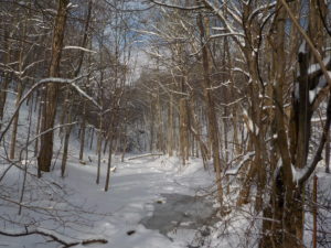
 Update on hiking conditions: There is about a 4 inch base of thick wet snow, with another inch or so of powdery snow on top. Conditions should be good for hiking in boots with traction devices and poles.
Our March 3 hike will be a ramble around Onanda Park, a town park along the west shore of Canandaigua Lake and Barnes Gully. We will cover the upland trails on the north and south sides of the gully, a brief walk beside the gully itself, and the lakeshore side of the park, where we can enjoy skipping stones and the fishing pier. Trails may be muddy, so we recommend traction devices and poles, along with layers and water.
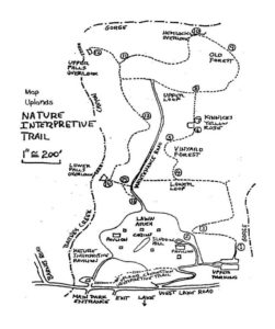
Onanda Park is an 80 acre property, of which 7 acres is level ground along the lake and 73 acres is the upland section across the road. It was a YWCA girls’ camp from 1919 to 1989, and became a public park in 1989 under a joint agreement between the DEC and the Town of Canandaigua.
Meet at the parking lot on the east (Lakeshore) side of County Road 16 (a.k.a West Lake Road) at 1:45. Address is 4965 County Road 16.
Climbers will head across the road to the upland trails, making two intersecting loops around the perimeter of the park, including the north and south rims of Barnes Gully (about 3.2 miles). Climbers will then follow the streamside trail west from the road as far as we can go without getting our boots wet, and return to the lakeshore area for stone skipping if conditions permit. Total distance is about 3.9 miles.
 Tourists and Naturalists will follow a similar plan, except making one loop rather than two and without the streamside trail, to limit the distance to 2-3 miles, depending on the route selected.
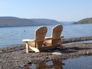
Optional supplementary activities: fishing and fossil hunting from the shore or the Fishing Pier.
Social – Join us following the hike for a potluck social in Cheshire at Mark’s brother’s house. Bring a dish to pass (or make a small donation to to social fund) and bring your prefered beverage. We will have electric plugs and a stove to warm things up. Directions will be at the hike.
Directions:
From Springwater (and Wayland, Dansville): Take Route 15 south to Wayland and Route 21 east/north to Naples. Continue through Naples and Woodville. 2.75 north of Woodville, take a right to follow Route 21 north where it splits with 64. Go another 4.9 miles, then make a right on County Road 16 (a.k.a West Lake Road). Enjoy the panoramic view of the lake. In 2 miles you will be down near the lake shore. Make a right into the main entrance to Onanda Park. Parking area is on your right.
From Rochester and points north/west/east: Head to Routes 5 and 20 via Bloomfield or Canandaigua. About a mile west of the City of Canandaigua, turn south on NY-21S. Go 4.3 miles, through the hamlet of Cheshire. At the south end of Cheshire, just over the hill, take a left on Deuel Road. In 2.2 miles, Deuel Road will end at County Rd 16 (West Lake Road). Make a right and go down the hill for .5 miles. The Onanda Park main entrance will be on your left. Park on the lot on your right.
From Hemlock and Honeoye:Follow NY-20A east for 7 miles from Honeoye. Turn right on NY-64S and (in 1.5 miles) take the first left turn onto Bristol Rd. In 0.8 mi., turn right onto Montanye Rd, which turns into Goodale Rd. Turn right on NY-21S in Cheshire. At the south end of Cheshire, just over the hill, take a left on Deuel Road. In 2.2 miles, Deuel Road will end at County Rd 16 (West Lake Road). Make a right and go down the hill for .5 miles. The Onanda Park main entrance will be on your left. Park on the lot on your right.