
N Main St
Mt Morris, NY 14510
USA
 This week, Springwater Trails is starting a series of monthly hikes along the Letchworth Branch of the Finger Lakes Trail. This 25 mile long trail passes along the top of the Letchworth Gorge on the eastern side of the park. The trail is known for beautiful views of the gorge for a vantage point that is often unfamiliar to regular visitors to the Letchworth Park. In addition to the main gorge and the Genesee River, there are many small streams that cross the park from east to west, carving gullies that must be crossed by hikers. So, we will often experience detours from the edge of the Gorge where these gullies are steep and deep, eastward to the head of the gully where crossings are possible.
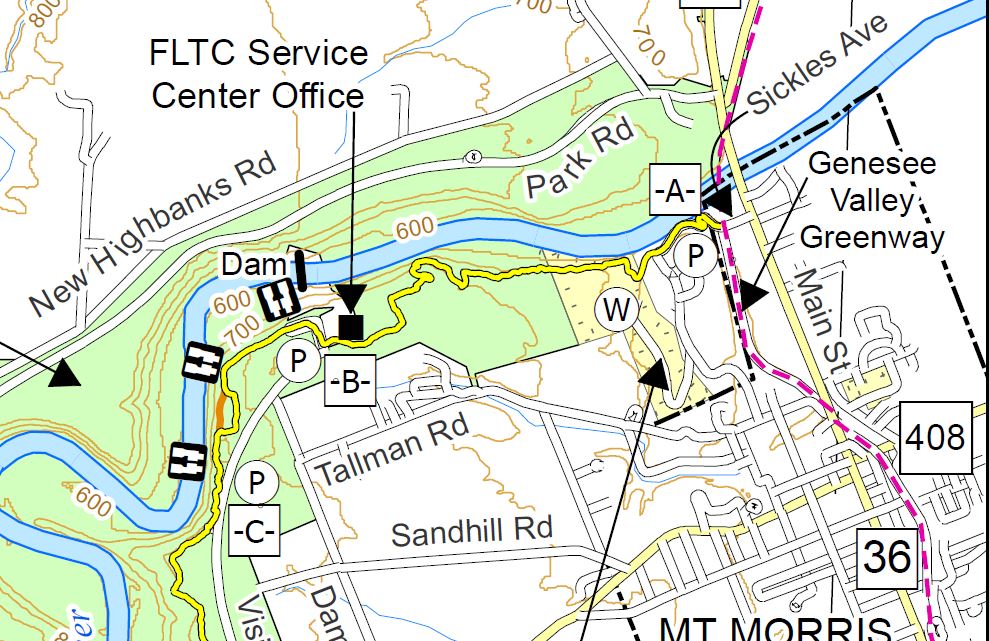
Our hike this Sunday will begin on the Greenway in Mt Morris. The Climbers will hike through the Al Lorenz County Park, past the Mt Morris Dam to Access C, a total of about 3.5 miles. The first half of the hike will be up a fairly steep hill to reach the flat area at the top of the gorge. The Tourist group will do the same hike in reverse – trading the steep climb for a steep descent. The Naturalists hike will be primarily flat. They will start at the Dam parking area and head north to the Wildlife Loop for a 1.5 mile hike. After returning to the parking area, the Naturalists may want to head south on the Letchworth Branch trail to enjoy some views of the gorge.
All hikers will meet at the parking area 400 feet north west of State St on Main St in Mt. Morris. Please come early to help arrange car pooling to Access Pt C at the south end of this week’s hike.
The Tourists will drive to Access Pt C (Hogsback overlook) to start their hike. After parking, they will immediately enjoy a view of the Letchworth Gorge. Turning to the right, they will follow the Letchworth Branch blazed yellow for about a mile to the Mt. Morris Dam Visitor Center parking lot. Yellow blazed are painted on the lamp posts down the center of the parking area, Continue across the parking area to the right corner of the visitor center where you will find a mowed trail heading diagonally across the field. On the far side of the field, continue to follow the yellow blazes. When you join the Wildlife loop, stay to the left to follow the yellow and blue blazes. The yellow blazes will leave the Wildlife loop to the left to start the descent along the gorge. After passing an old log cabin, you will see the pavilions of Al Lorenz County Park. Take the lane to the left up the hill to the Livingston County campus. Turn left on Sickles Rd and walk the road down around several switchbacks. At the bottom, the yellow blazes end at the Genesee Valley Greenway. Turn right on the Greenway and follow the trail beside the old Genesee Valley Canal to Main St and the awaiting cars.
The Naturalists will car pool to the Mt Morris Dam parking area to start their hike. If they arrive at the parking area before 4:30, they may want to spend a few minutes in the Visitor’s Center. Exiting the visitor center, turn left on the sidewalk and walk to the field. Follow the yellow blazes for the Letchworth Branch into the woods to the Wildlife Loop. Turn right onto the Wildlife loop, follow the blue blazes around until it rejoins the Letchworth Branch. Continue on the Blue/Yellow trail back to the start of the Wildlife Loop, then continue on the Yellow Letchworth Branch to return to the Visitor’s Center. Based on time, the Naturalists may want to spend time in the park around the Dam, or go to the South end of the parking lot and pick up the Letchworth Branch for a short out and back hike.
The Climbers will start from the meeting place along the sidewalk down hill to the Genesee Valley Greenway. Cross Main St and stay on the Greenway to Sickles Ave to the start of the Letchworth Branch of the FLT. Turn left and follow the road to the top. There are occasional blazes as you go up. At the top the road turns left but the trail continues straight (W) past a
dumpster on the right, down a lane to Al Lorenz County Park. Stay to the right to find the yellow blazes, into Letchworth Park, along the gorge. At the sign for the Wildlife Loop, stay on the Letchworth Branch. The trail will come out onto a mowed path to the Visitor Center, along the length of the parking lot, to a kiosk where the trail enters the woods and follows the gorge to Hogsback overlook (Access C). The climbers will then use the Tourist’s cars to return to the parking area (I hope you remembered to swap keys when you met the tourists on the hike up).
Following the Hike, we will all drive to Al Lorenz park for a pot luck social. Please bring a dish to pass and your own beverage. In case of rain, we will go to the Charred American Bar + Grill at 36 Main St across from the meeting area.
Directions to the meeting location:
From Springwater: Follow NY-15 N for 1.5 mile. Turn left on Liberty Pole Rd, which becomes Springwater-Scottsburg Rd, and Groveland Scottsburg Rd, for a total of 8.1 miles. Turn right onto NY-63 N. Turn left onto NY 408 into Mt. Morris. At the Main St light, turn right and park in the first parking area on the right (about 400 ft.).
From Wayland: Head south on NY-15. Turn right onto I-390 past the Dansville exits to Exit 36 (16.3 mi) for NY 36, Mt. Morris. Turn left on NY-36N for 5.2 miles onto Main St. The parking area is about 400 feet beyond the light at NY 408 on the right.
From Rochester: Take I-390 S to Exit 7 for NY 408 Mt Morris. Turn left (south-west) on NY 408. At the Main St light, turn right and park in the first parking area on the right (about 400 ft.).
Directions for carpools to the hike start: Turn left onto Main St. Take the second right on Chapell St (NY 408S) In 1.8 miles, turn right onto Visitor Center Rd. Tourists will stop in 1.1 miles at the Hogsback Overlook. Naturalists will stay on Visitor Center Rd for 1.7 miles to the parking log at the center.
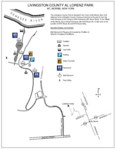 Directions to Al Lorenz Park:
From Main St Parking Lot: Turn right onto Main St. Turn left onto Grove St. Turn right onto Murray Hill Dr. Take the first left onto Al Lorenz Dr. Take the first right into the park.
From the Visitor Center parking lot: Turn right onto Visitor Center Rd. Take the first left onto Damsite Rd. Turn left onto Tallman Rd. In 1.2 mi, turn left into the park.
From Hogsback Overlook parking lot: Turn left onto Visitor Center Rd. Take the first right onto Damsite Rd. Turn left onto Tallman Rd. In 1.2 mi, turn left into the park.
A brief preview of the Springwater Trails Letchworth Series.
Our series of hikes will start at the northern end of the trail in the village of Mt Morris. The first hike (August) starts on the Greenway in Mt Morris to the Letchworth Branch intersection and upward past the Mt Morris Dam to Access C, a total of about 3.5 miles. In September, we will continue with a 4 mile hike to Access D, then 2.9 miles to Access E (Oct), 6 miles to Access F (Nov), 2.4 miles to Access G (Dec), 3.6 miles to Access H (Jan), 4 miles to Access K (Feb) and a final 3 miles (or so) in March to meet up with the main Finger Lakes Trail just past Portageville. The construction of a new railroad bridge over the Genesee at the south end of the trail has required re-routing of the Letchworth Branch onto road walks. We expect the trail to be reopened by March, but if necessary we will postpone our final hike until the trail is opened.