
Bloomfield
NY 14469
USA
Boughton Park is located in the northern part of the Town of East Bloomfield, Ontario County. From the 1920s to the 1980s Fairport used the two reservoirs at this location for their water supply. We will have three hikes around these old reservoirs (now often referred to as “ponds”), one of which will be “accessible” to hikers on a scooter. The trails are good with very mild elevation changes. There is poison ivy beside the trails. If you stick to the trails you are okay, but be sure you can identify it if you get off trail. It is often just beside the trails, but not on them.
Carpooling: Parking (by permit only) is available at the trail head, but we are limited to 10 parking permits. Please plan to carpool, to preserve both gas and parking spots. Unsupervised carpools will start from the Springwater Town Hall or from the Sandy Bottom parking area at the north end of Honeoye Lake. Plan to arrive at Sandy Bottom at 1:15 to leave promptly at 1:25 for the hike. Or meet at the Springwater Town Hall at 1:00 to leave promptly at 1:10.
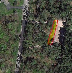 Hike Meet Location: All hikers will meet at the Stirnie Road parking lot. Please park at the Stirnie Road entrance, where the pavilion is located. We will have parking permits when you arrive – so please be on time! For clarity there is another parking lot off Boughton Rd, which we are NOT using as our “hike meet location”.
Optional After-Hike Social: We are planning a social at the pavilion near the parking. Please bring a dish to pass and your own beverage.
Hike Plans:  Boughton Park consists of 330 acres and 5 miles of designated trails. The area has some rolling hills with perhaps 50-100 foot max elevation change. The park is reserved for residents of Victor, East Bloomfield and West Bloomfield and their guests. On Sunday, Springwater Trails will be guests. For more information, click on the Boughton Park link.
The Victor Hiking Trails Seneca Trail connects to the north end of Boughton Park and from there, you can hike all the way through Victor to Perinton and the Crescent Trail. The section from Boughton Park to the Apple Farm is closed during hunting season, so we will stay within the Park boundaries.
 Hike Routes: For a larger map, click on the map or check the board at the trailhead.
Climbers: Climbers will hike around both ponds, (including a new loop at the southwest corner), then north along the west pond, to the east pond, and south along the east side of this pond, followed by the gravel road back to the north end, and along the west pond back to the pavilion, this is about 4 miles.
Tourists: Tourists can keep it to 2 miles by making a loop around the west pond only.
Naturalists: Naturalists can make the easy hike north to views of the west pond, then on the gravel road to the west pond, and return to the pavilion, 1 mile total.
Directions: To carpool locations
Springwater Town Hall: Please be at the Springwater Town Hall at 1:00PM to carpool to Boughton Park. Click here for directions to the town hall. Remember, this is an unsupervised carpool and drivers will be leaving promptly at 1:10PM.
Sandy Bottom: If Honeoye is more convenient, please meet at Sandy Bottom on West Lake Rd at 1:15PM to carpool. Drivers should leave promptly at 1:25PM.
Directions: TO THE HIKE: Set your GPS to (42.937581, -77.441284) or to 1911 Stirnie Rd (parking is on the east side of the road).
From Honeoye and the Sandy Bottom Park (carpool location) :
– From Sandy Bottom, head north on West Lake Rd.
– Take Rt 20A east for 5.9 miles
– Turn left onto CR 2 for 1 mile, then continue straight onto Oakmount Rd (CR2 turns right).
– Turn left onto Rts 5&20 and travel 1 mile.
– Turn right onto NY-64
– In a half mile, turn right onto Eddy Rd.
– Take the first left onto CR 39 and continue onto CR 39 for 1.7 miles.
– Turn right onto Boughton Rd (CR 39 will continue to the left)
– Take the first left onto Stirnie Rd. The parking area is 0.8 miles ahead on the right. (past a curve to the right, and a curve to the left)
From Springwater and the Town Hall (carpool location):
–Take Rt 15A north from the flashing light in Springwater.
–Turn right onto Rt 20A toward Honeoye. After 4.0 miles
– Turn left on CR 37 to go north to West Bloomfield.
– Turn right onto Rts 5&20 east at the West Bloomfield Congregational Church.
– In 3.7 miles, turn left onto Cannan Rd, (its the first road that crosses US20 both left and right).
– Cross NY64 where the road becomes Bennett Rd.
– At the first road, turn right onto CR 39.
– At the right hand curve on CR39, take a slight left onto Boughton Rd
– Take the first left onto Stirnie Rd. (It’s a VERY VERY short travel on Boughton Rd) The parking area is 0.8 miles ahead on the right. (past a curve to the right, and a curve to the left)
From Rochester area:
– Take I490 East to the Victor Exit 29.
– Merge onto Rt 96 S into Victor.
– Turn right onto Maple Ave (Rt 444) (follow the sign to Bristol Mt).
– At the flashing light turn right onto Boughton Hill Rd (CR 41) (At Ganondagan)
– Take the 1st left onto Murray Rd.
– At the T, turn right onto Town Line Rd.
– Take the 1st left onto Stirnie Rd. The parking is on the left after 0.4 miles.