 Please join us this Sunday as we complete the Bristol Hills Branch of the Finger Lakes Trail and celebrate this treasure for our area.
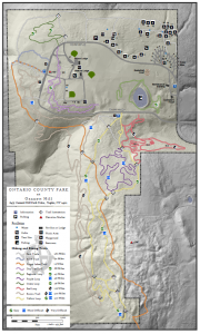
This hike will be on the northern most section of the BHB between Ontario County Park and West Hollow Rd. Highlights include a nice wooden overlook of CR 33 and the hills beyond, and a pretty beaver pond which we will see up close and from the top of a hill. Almost all of the hike will be in woods, so you can skip the sun tan lotion, although little gnats may bug you.
 For this hike, we will all meet at Ontario Park pavilion 6. Enter the park, pass the camping and cabins and turn in at the sign for All Pavilions. The pavilions are in order. Following the hike, join us for an optional social at the pavilion. We will have a grill and hot dogs, so bring a dish to share and your own beverage.
NOTE: Dogs are permitted in the park only if on a leash. No one can carry weapons in the park.
The Naturalists will walk north west from the pavilion, across the baseball field, to pavilion 3. At the corner of the road, a trail leads west to the entrance of the BHB (look for Finger Lakes Trail signs). Once on the trail, follow orange blazes. The trail is well marked going out. First you will pass the overlook. Take the stairs down to the left, and the trail goes out the corner of the clearing near the stone wall. Continue to follow orange blazes until you come to the mail box where you can sign in. On Wednesday, there were no pens or pencils, so the first hiker who remembers to bring a pen should leave it in the mailbox for other hikers. At the mailbox, turn around to follow the trail back. If you see a right turn (away from the steep hill), you can take that trail back to the road and the shelter. Otherwise, stay on the orange trail back. The outward portion of this trail has one steep climb, which isn’t very long. This hike is about 2.5 miles with one steep climb.
The Tourists will start out with the Naturalists, but will continue on the orange trail past the mailbox. The mailbox is at the highest point on the Bristol Hills Branch, so most of the rest is downhill to the beaver pond. There are several gates crossing from the park to private land, which are easy for you to pass through. After the beaver pond, cross the outlet creek for another steep climb to overlook the west side of the pond. From there it is about a mile out to CR 33 (West Hollow Rd) and the cars that the climbers have left. This hike is 3 miles with two short climbs and one 600 foot descent.
Meanwhile, the climbers will carpool to West Hollow Rd and park at the Boy Scout lot on the west side of West Hollow Rd. From the lot, they will cross West Hollow Rd and walk south about 100 feet. Cross the road ditch at the post with the first of many orange blazes. From there, follow the blazes through the woods to the beaver pond, then up a long hill to the mailbox. From the mailbox, it is about 1.5 miles to the overlook and back to the pavilion. This hike is 3 miles with a 600 ft climb.
DIRECTIONS: Note: The road through the park is one way counter-clockwise. Google maps takes you the wrong way around the loop!
From Springwater, Wayland and Naples: Take NY 15 south from Springwater to Wayland. At the light, turn left onto NY-21. At the stop sign in N Cohocton, turn left to stay on NY-21. At the stop sign in Naples, turn left to stay on NY-21. Continue on NY-21 for 1.8 miles through Naples. Bear left onto CR 12 (Bristol Springwater Rd) up the hill. In 1.9 miles bear left onto Rhine St. In a half mile, at the four way stop, continue straight onto Powell Rd, which becomes Gannett Hill Rd in 0.3 miles. In 3.2 miles, continue straight after the stop sign into the park. You will pass the tent camping area, and the cabins on the right, before you come to the entrance to the pavilions on the left. We will park at pavilion 6. Come a bit early to enjoy to view across the valley and to use the restrooms.
From Canandaigua: Take NY 21S to South Bristol. Turn right onto NY 64N into South Bristol. In 0.4 miles, turn left onto Gannett hill Rd (see the sign for Ontario County Park). At the stop sign at the top, turn right into the Park. You will pass the tent camping area, and the cabins on the right, before you come to the entrance to the pavilions on the left. We will park at pavilion 6.
From Honeoye: Take US-20A east through Honeoye. Turn right onto E. Lake Rd, then left onto CR 33 (Egypt Valley Rd). In 5.9 miles, continue straight onto CR 34. At the tee, turn right onto NY 64S. In 1.9 miles, turn right onto Gannett Hill Rd (see the sign for Ontario County Park). At the stop sign at the top, turn right into the Park. You will pass the tent camping area, and the cabins on the right, before you come to the entrance to the pavilions on the left. We will park at pavilion 6.
Directions from the park to the parking area on West Hollow Rd (Climbers): Exit from the pavilions, and turn left onto the park road. Follow the park road around to the 4 way stop. Turn right onto Gannett Hill Rd.In 1.6 miles, turn right onto Porter Rd. At the end of Porter Rd, turn right onto W. Hollow Rd. In 1.2 miles (watch your mileage), there is a parking area on the left. This parking area is hidden, so watch carefully. If you get to the Gell Center on the right, you have gone too far.
Directions from West Hollow Rd back to the park (Tourists): At the end of the tourist hike, the trail goes right to cross West Hollow Rd into the parking area. Drive out of the parking area and turn right onto West Hollow Rd. In 1.2 miles, turn left onto Porter Rd. At the end of Porter Rd, turn left onto Gannett Hill Rd. At the 4 way stop, continue straight into the park. Come to Pavilion 6.
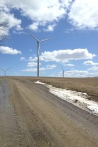
 Come walk among the Dutch Hill Wind Farm, part of the 125-Megawatt wind farm located in Cohocton NY, on Sunday, July 29, 2018 at 4pm. We will meet at our ending point just off Shults Hill Rd in the Town of Cohocton and car pool to our starting point. Location is first road on the right past the Lawrence Parks Recreation area 10726 Atlanta Back Road in the Town of Cohocton. This will be a 3.6-mile hike on rolling dry gravel roads among the farm fields. Milkweed is in bloom so butterflies aplenty along with the hawks soaring above. If the climbers want a longer hike we will drop them off on a .6 mile, uphill, through the woods, on a seasonal road for them to walk to the starting point.
 Please join us this Sunday as we complete the Bristol Hills Branch of the Finger Lakes Trail and celebrate this treasure for our area.