Posted on by

FLT Letchworth Branch Series – Portageville == CANCELED

Rain, Father’s Day, busy week – All adds up to canceling today’s hike.  Sorry for the inconvenience:


Today’s Hike is Canceled! Join us next Sunday.


Happy Father’s Day. Please join Springwater Trails for a hike along the Genesee River. Bring your father or your grandson and enjoy the views. Because of Father’s Day, please leave a message if you are planning to hike with us. Please check the website the day of the hike – We will cancel at 1:00, if no one plans to hike.  Thanks.

This week will mark the end of the Springwater Trails Letchworth Series and the start of a new series showing off the main Finger Lakes Trail between the Letchworth and Bristol Hills branches. Our Letchworth Series was plagued with weather and water, so we will be leaving Letchworth with a few sections undone. But it is time to move on.

This hike will start in the town of Portageville south of the Letchworth Park. We start on a portion of the trail which is shared with the Genesee Valley Greenway and will end on a section that is shared with the North Country Trail. We can dedicate this hike to continued cooperation between hikers and hiking groups.

All hikers will meet in Portageville south of the bridge on NY 436 across the Genesee River. NY 436 turns right in the center of Portageville but the trailhead is straight ahead about 100 feet up Main St (south of the Hotel).

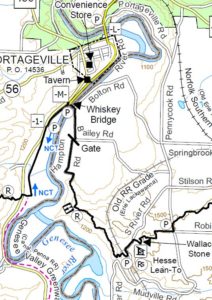
The first section of the hike follows the old railroad bed, cutting across a loop in the river for a mile.The Naturalists will continue under the Whiskey Bridge and south along River Rd (a little used section of dirt road) to NY 19A, where they will take a sharp right turn onto the main Finger Lakes Trail and hike back to the Whiskey Bridge. After a short exploration of the bridge itself, the Naturalists will return to the west side of the Bridge and scramble down a steep connection to the right back to the branch trail.  Turning left, they will retrace the branch trail to Portageville.

Meanwhile the Tourists and Climbers will leave Portageville on the branch trail.  When they come to the Whiskey Bridge, they will turn right to climb up to the entrance to the bridge and the main trail. After crossing the river, the trail continues along dirt roads to a nice view of the river, for about 3 miles to a parking area on S River Rd, where we will have a car waiting to return to Portageville.

Following the hike, join us for a social at the Sunrise Restaurant in Dansville.

Directions:

From Springwater, Wayland and Dansville: Take 15 S to Wayland. Turn right and follow NY 63N to Dansville. Turn left on NY 36N (Ossian St). In half a mile, stay straight onto NY-436W (Ossian St). Continue through Nunda and past the entrance to Letchworth. At the bottom of the hill you will cross the Genesee River into Portageville. At the cross-street Hamilton St, (the Genesee Falls Inn is on the left), continue straight as 436 turns right. The Letchworth Branch Trail enters the woods on the left.

From Honeoye and Hemlock: Take NY 20A west through Livonia and Lakeville. Turn left onto the ramp for 390S. Take the next exit for NY 408S. Stay on 408 through Mt Morris into Nunda. Turn right at the light on NY 436W. Go past the entrance to Letchworth. At the bottom of the hill you will cross the Genesee River into Portageville. At the cross-street Hamilton St, (the Genesee Falls Inn is on the left), continue straight as 436 turns right. The Letchworth Branch Trail enters the woods on the left.

Directions to the Social: Follow 436E back through Nunda to Dansville. Continue straight onto NY-36. Turn left on Main St.  The restaurant is on the right with parking on the street or in the rear.

Posted on by

Middlesex Valley Rail Trail

This Sunday we will hike the Middlesex Valley Rail Trail, which runs northeast from Naples, passing through the lowlands of the Hi Tor Wildlife Management Area. The 7.2 mile rail trail is parallel to Route 245, and follows alongside of sections of the West River. We will hike on the section between Parrish Road and Cayward Cross Road, placing cars at several different parking areas along the way to allow for several distances of hiking. The trail is level and wide and slightly downhill, easy walking, though poles will be helpful for any muddy areas.The Middlesex Valley Railroad began service in 1892 between Naples and Stanley, with connections to Geneva, Canandaigua and Wayne County. In 1895 it became part of the Lehigh Valley Railroad system, and continued in service until 1970.  Now part of the State-owned Hi Tor area, most of the trail is a raised path with wetlands on either side – some shrubby and some forested.  Along the way are waterfowl nesting boxes, and about a mile from the north end is a heron rookery. Wendy has told us that there are limited babies this year possibly due to eagles. Hopefully we will see some wildlife.

We will meet at 4 PM at the parking lot on the north side of Parrish Road, which runs across the valley from Route 21 (near Monica’s Pies) to Route 245 (near the base of Conklin Gully).  Will leave enough cars there to accommodate the return trip for all the Climbers. We will then leave enough cars to accommodate the Tourists at the Sunnyside parking lot, along the way to our hike starting point.  Everyone will begin the hike heading south from the Cayward Cross Road parking area. PLEASE wear clothing appropriate for tall grass, bugs and mud. Bring bug spray and a water bottle.

Naturalists will hike down the trail as far as the rookery, then return to their cars, a total of 2 to 2.5 miles.  Tourists will hike through the rookery and on to Sunnyside, a total distance of about 3 miles. The Climbers will hike past Sunnyside and on to Parrish Road, for a total distance of about 5.6 miles.  The southernmost 1.2 miles of the trail, extending past Parrish Road to Naples, is currently closed due to a bridge outage.

Following the hike, please join us for an optional social at the Redwood Restaurant on Rt. 21S in Naples.

Map: See map here: MV Rail Trail map

Directions to the Hike Meeting Point:
From Springwater/Dansville/Wayland: Take Rt 21N into Naples. Turn left onto Main St for 1.5 miles. Turn right on Rt#245 (across from Bob and Ruth’s). Continue 1.5 miles, make a left on Parrish Rd. Parking area is on the right, in about .2 miles.

From Honeoye: Take Rt#36 south into Naples, left on Main St for approximately 1.25 miles. Right on Rt#245 (Across from Bob and Ruth’s). Continue 1.5 miles then left on Parrish Rd. Parking area is on the right, in about .2 miles.

From Canandaigua: Take Rt#21S to Woodville. Keep straight toward Naples. Turn left on Parrish Road about 1.5 miles past Woodville, just after you pass Monica’s Pies. The parking area will be on your left, in about .5 miles.

Posted on by

FLT Letchworth Branch Series

Last August, Springwater Trails started our Letchworth series. This series, which occurred once a month (usually the 3rd Sunday of the month), had to goal of hiking the entire Letchworth Branch in 2 hours segments. We have done the following hikes:

August – Mt Morris (Access A) to the Dam Visitor Center (Access B)
October – Access D to Hogsback overlook (Access C) – time constraints meant we missed continuing to the Dam Visitor Center (Access B).
November-Access D to Access E.
December – Access F to the river.
January and February – Canceled. 
March – Dygert Rd (Access H) to Oakland Rd (Access G).
April – The parade grounds (Access K) to Dygert Rd (Access H).

So what is left.

Access B to Access C – This short section is left as a personal exercise, next time you are in the area.
Access E to F. – This is a long hike which we are planning for this Sunday when a 2:00 start and an 8:30 sunset means we will have time to complete the hike.
Access F to G – Next month’s hike. (Remember, June hikes will start at 4:00)
Access K to L – This section from the Parade Grounds to where the trail returns to the road NY-436. north of Portageville, is currently a road walk. We will come back to this hike when the regular trail is reopened in the future.
Access L to the main FLT trail (Access N) – This 2.4 mile section follows the river bed along the old rail bed, and is mostly flat. We plan to complete this section in July.

All hikers will meet at 1:50 at Access Pt F on River Rd near the intersection of Picket Line Rd. We will then carpool back north to Access E in the Tourist and Naturalists cars. If you are running late, please meet us at Access E between Ridge Rd and Frost Rd. The hikes will take almost 3 hours, returning to the cars at about 5:00.

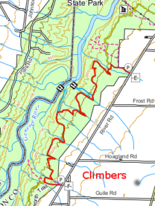
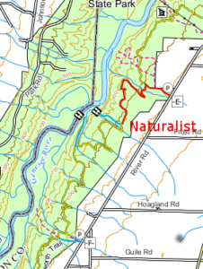
The Climbers will follow the blue access trail from the road (Access E) for 0.4 miles and turn left onto the main yellow trail. Continue on the main trail for 5.3 miles to a blue access trail going to the left. Access F and our cars are 0.3 miles up the access trail. This trail crosses many stream, some of which have steep sides. With all of the rain, we expect water is all streams, so be careful crossing each one. Total hike is 6 miles.

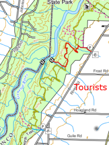
The Tourists will do an out and back hike of 4.6 miles to an overlook of the river and gorge. You may want to carry binoculars and check out the birds and other wildlife in the gorge. Like the Climbers, the Tourists will follow the blue access trail from Access E. Turn left onto the main trail. In a mile and a half, turn right on a blue side trail leading to the overlook (0.4 miles). After taking your time with the view, follow the blue trail back. Turn left onto the main trail. Its 1.5 miles back to a right turn onto the access trail, then back to the cars.

The Naturalists will follow the Tourists to the overlook turnoff. At the turnoff, the Naturalists will turn around, and return to the cars. This hike will be 3.8 miles (since it is an out and back hike, the Naturalists hike leader has the option to turn around earlier).

Following the hike, please join us for Pizza at the Nunda Pizza Corner on NY 408 and East St in Nunda.

Directions

From Springwater: From the light at the 4 corners, go west to follow NY 15 N for 1.5 miles to the top of the hill. Turn left onto Liberty Pole Rd (CR 38) and continue straight for 8.1 miles to Groveland. Turn left on NY-63 S and then a quick right (0.3 miles) onto NY-258 across the flats. In 1.9 miles, turn right onto NY-36 N. Pass the Correctional Facility and turn left (in 3.1 miles) on Dutch Street Rd (CR 30). Turn left to stay on Dutch Street Rd when Cleveland Rd enters from the right. Take the next right onto Ridge Rd for 3.5 miles. Turn left onto River Rd. In about half a mile, you will pass Access E on the right. Continue for 2.3 more miles past Frost Rd, Hoagland Rd, and Picket Rd. Parking for Access Point F will be on the shoulder.

From Wayland and Naples: Follow NY-21S to Wayland. Turn left (South) on NY-21 at the light in Wayland.  In 1.8 miles, turn right onto I-390N through Dansville, Use exit 6 and turn left onto NY-36 N for 2.3 miles past the Correctional Facility.  Turn left onto Dutch Street Rd and follow the Springwater directions above.

From Geneseo:  Take South St west until it turns left and becomes Mt Morris Rd. In 2.0 miles, continue straight onto NY-63S. In 2.2 miles, the road curves to the right and becomes NY-48S. (63 turns left). Continue on NY-408S into Mt Morris. Turn left on Main St, then immediately right on Chapel st, to stay on NY-408, In 2.5 miles, turn a slight right onto River Rd. You will pass Access E on the right in 2.5 miles. Continue for anothe 2.3 miles to Access F and shoulder parking. 

From Rochester: Take I390 south to exit 7. Turn left onto NY-408S and follow the Geneseo directions above.

Direction to the Nunda Pizza Corner: Head south on River Rd.  Take the first left out to NY-408. Turn south on 408 into Nunda.  The pizza will be on the left.

Posted on by

No Hike – Easter

Springwater Trails is taking this week off.  Please join us next Sunday for our annual Earth Day spring cleaning on Rt 15 through Springwater.