Posted on by

Old Bald Hill North – Directions

The Springwater Trails hiking group - June 2011

The Springwater Trails hiking group
June 2011


The house is located on the east side of the road at 5107 Old Bald Hill Rd (North) next to the blue farmhouse on the big curve.

Old Bald Hill Rd (North) is just a little south of Hemlock off Rt.15A, across from the entrance to Hemlock Park. Note that Old Bald Hill Rd S starts at the top of Bald Hill near Rob’s Trail and is a different road.

From Springwater and points south: Take 15A North from the Springwater light for 10.1 miles.  At the north entrance to Hemlock Park, turn right (away from the park) onto Old Bald Hill Rd. Follow Old Bald Hill Rd for half a mile to the curve.  The driveway is on the left at the curve.

From Hemlock NY and points north: Take 15A South from the intersection with 20A for 0.7 miles.  At the north entrance to Hemlock Park, turn left (away from the park) onto Old Bald Hill Rd. Follow Old Bald Hill Rd for half a mile to the curve.  The driveway is on the left at the curve.

Posted on by

Richmond Mills Rd – Honeoye Outlet – Directions (42.829,-77.5285)

DEC Land at Richmond Mills RdThere is a small parking area and kiosk on the north side of County Road 15 (aka Richmond Mills Rd.) 2 tenths of a mile east of County Rd. 37.  There is ample parking in the gravel lot and on the shoulders of CR 15.

From Springwater: Head north on Rt 15A through Hemlock.  Turn right on CR 41 at the intersection where 20A goes left toward Livonia.  This is Richmond Mills Rd.  Follow Richmond Mills for 4.3 miles through the 4-way stop sign.  The parking is on the left.

From Honeoye: Go West on 20A from the Village.  Turn right onto CR 37 (Rchmond Center Rd).  Richmond Mills is the first right 2.6 miles north.  Turn right on Richmond Mills Rd.  The parking is on the left about 0.2 miles from the corner.

From Rochester: Take 15A South to Lima.  Turn left on Rts 5&20 for 3.8 miles to West Bloomfield. (You can also get to Lima and W Bloomfield from Exit 10 on 390S – head east on 5&20). Turn right and follow CR 37 south for 5.6 miles.  At the 4-way stop, turn left on Richmond Mills Rd (CR15).  The parking is on the left about 0.2 miles from the corner.

From Geneseo:  Take R20A East.  Continue straight across 15A (Rt 20A curves south onto 15A).  Richmond Mills continues east from 15A.  Follow Richmond Mills for 4.3 miles through the 4-way stop sign.  The parking is on the left.

Posted on by

Atlanta North Cohocton Club Trail – Directions (42.55365,-77.4794)

We will park at the corner of Grays Corner Rd/Beecher St/CR 39A and Main St/CR 36 in Atlanta, NY. Parking will be at the building with the red/white and blue roof on the corner.  (The north east corner).

From Springwater: Go south on Rt 15 to Wayland.  Turn left on Rt 21 toward N Cohocton and Naples.  Follow the directions from Wayland.

From Wayland: Go East from Rt 15 on Rt 21 toward N. Cohocton and Naples. At 6.0 miles, turn right onto Grays Corner Rd, (CR 39A) toward Atlanta.  Continue 0.6 miles to Main St.  Parking is at the building with the red/white and blue roof on the left before Main St.  (The north east corner).

From Naples, Honeoye and Canandaigua: From Honeoye, take CR 36 to Naples.  Take Rt 21 S through Naples to N. Cohocton.  In N Cohocton, turn right to stay on Rt 21.  Take the first Left on University Ave (CR 39).  After 0.6miles turn a slight right onto E Main St.  After 0.4 miles, parking will be on the right just before Beecher St.

From Geneseo, Dansville and Rochester: Take 360 South to the Wayland Exit #3.  Turn left onto Rt 15 North, go under the expressway and turn right onto 415S immediately after the northbound exit. Take the 4th left after 2.2 miles unto CR 36/ Atlanta East Wayland Rd. Follow CR 36 for 4.0 miles into Atlanta.  Parking is on the left just past Beecher St.

If you use Google maps, we will park at Beecher St (North to south) and Main St (East to West).

If you are on bing.com/maps, the roads show the County number (CR36 and CR39A). CR39A is called Beecher St and Grays Corner Rd.

MapQuest does seems to match Bing, except it does not mention CR39A.

PS (All county roads mentioned here are Steuben County roads except for CR36 from Honeoye).

The after hike social will be at Cheryl Deusenbery’s, 4010 State Rte 21 N.   From Wayland, the house is 5.2 miles from the Wayland traffic light. (just before Garlinghouse Rd/Ross Rd) Food can be dropped off before the hike if need be.

Posted on by

Springwater Center – Directions

Springwater Center is located off Route 15 west of Springwater (approximately 45 miles south of Rochester).

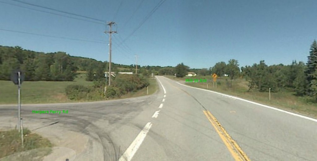
From Springwater: Take Rt 15 to the West from the yellow light intersection with Rt 15A.  Follow Rt 15 up the hill.  Turn right at the top of the hill on Mill St Ext (just across the road from Harpers Ferry Rd) – you will see a Dead End sign. Springwater Center is the third driveway to the left (0.1 mile along Mill St. Ext., you will see the sign). Follow the driveway for 0.6 miles to reach the Center parking lot. The main building is just past the parking lot.

Mill St Ext from Rt 15 coming up from Springwater

From Naples:  Follow Rt 21 South through N Cohocton to Wayland. At the light, turn right onto Rt 15 north. In 5 miles, at the flashing light in Springwater, turn left to stay on Rt 15 up the hill. Turn right at the top of the hill on Mill St Ext (just across the road from Harpers Ferry Rd) – you will see a Dead End sign. Springwater Center is the third driveway to the left (0.1 mile along Mill St. Ext., you will see the sign). Follow the driveway for 0.6 miles to reach the Center parking lot. The main building is just past the parking lot.

From Lakeville and Webster Crossing:  Take Rt 15 South from Websters Crossing for 2 miles.  Just past Liberty Pole Rd, you will see a flashing yellow light on a sign signalling the hill into Springwater.  Take the immediate next left off Route 15 onto Mill Street Ext. (you will see a Dead End sign). Springwater Center is the third driveway on the left (0.1 mile along Mill St. Ext., you will see the sign). Follow the driveway for 0.6 miles to reach the Center parking lot..

From Rochester: Take I-390 south to Exit 9 (Lakeville-Livonia-Conesus). Turn left on Route 15 South for approximately 18 miles. Two miles past Websters Crossing, you will see a flashing yellow light on a sign signalling the hill into Springwater.  Take the immediate next left off Route 15 onto Mill Street Ext. (you will see a Dead End sign). Springwater Center is the third driveway on the left (0.1 mile along Mill St. Ext., you will see the sign). Follow the driveway for 0.6 miles to reach the Center parking lot.