Hike Report 6/1/2014 hike – Mount Morris Dam Tour & hike
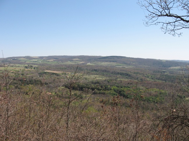
 Before our Sunday hike, Springwater Trails hikers toured the Army Corps of Engineers Mount Morris Dam, which is designed and used exclusively for flood control down river on the Genesee River from Mt Morris to Rochester since its completion in 1952. Headcount of 30 on the elevator including our tour guide/Park Ranger, Harmony. At least two were folks not specifically at the dam to join Springwater Trails, but benefited by the 12:30PM specially scheduled tour which still had openings in headcount. Harmony’s presentation was very informative and she fielded numerous questions along the way with some good mannered humor injected too. Three levels in the dam were viewed, and the dam top and lower viewing platform afforded some great views.
 We had some hikers new to S/T. And some with family members who opted to explore shops in the Village of Mount Morris instead of joining the main group for the dam tour &/or hikes. The mass of hikers attended the dam tour, hike, and social. A few opted for only one or two of the three, based on schedule, commitments, and preferences. And two founding S/T hikers who seldom have opportunity to hike with S/T, were able to make it for the social.
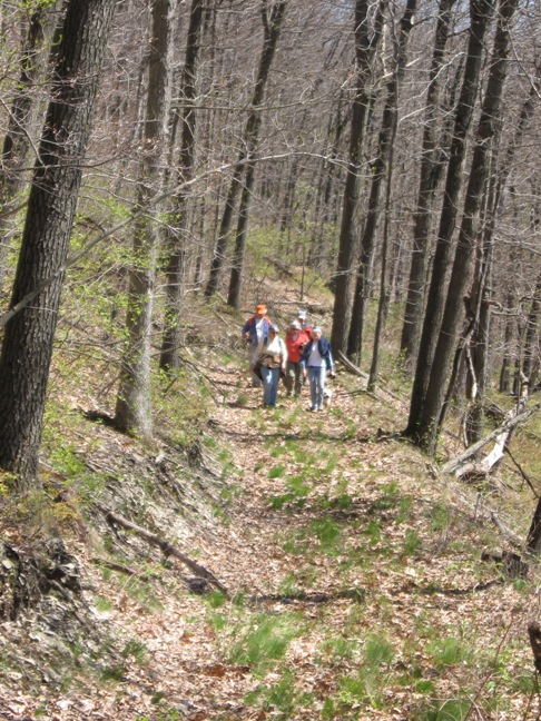
 Hike transport logistics: Four Tourists drove two Climber vehicles to “near” Access Point D on River Rd and hiked northward to Access point C where a car had been staged for Tourists. Ten Climbers hiked from Access Point B (the dam parking lot) to the cars left for them by the Tourists.
We did learn a small nuance (after the fact) about where Access Point D on River Rd is and where it is not. (It is not at a small parking lot and trail adjacent the overhead high tension power lines. It is ~ 1/4 mile north of the power lines, blue blazed trail.) Due to the misinterpretation, Tourists added probably a mile to their hike and likely neared the mileage of 5.28 miles covered by Climbers. (see Climbers GPS tracking below) All ended well with the Tourists the last group to finish the hike and make it to the social.
All hikers appreciated the shade of the forest canopy while hiking, and with only short occasional muddy sections hikers managed to basically stay clean and dry and relegate any mud accumulations to bottoms of hiking shoes only.
After-hike social at the MMDam Recreation Area large picnic shelter at the gorge overlook, started with conversations after various groups completed their hikes on this sunny day with high temps in the low 80s. Naturalists finished first and readied for the after-hike social. Naturalists and Climbers opted to wait in starting the pot-luck picnic until arrival of the Tourists, who had both Hike Planner and Assistant Hike Planner among them.
As usual, no shortage of food or variety, when all fare was brought out, main course of make your own coldcut sandwich and many more items. All was great … and wait for it, no duplicates. To name just a few, two personal outstanding culinary stylings toward my palate were John’s minced apple salad and the bountiful mixed legumes with sauce. Pam’s portable kitchen – on-site grilling of filled tortillas / quesadillas were also a hit.
**During the social one discussion was that at this point a few summer (July-Sept) hikes are still needed to round out the summer schedule. So, please if you have either a date in mind as a possibility for a summer hike, or hike locale in mind for a summer hike (or both) send a note to [email protected]
One new hiker to S/T (a Crescent Trail hiker) provided a GPS tracking of the route hiked by the Climbers, and a link. It is provided below for any hikers interested in the tracking. Thank You, Calvin, for providing it for all.
Reminders: (1) June-Labor Day, Springwater Trails hikes start at 4:00PM to avoid midday heat and high sun angles. That is unless otherwise specifically noted in Hike Announcement. (2) ADK Outdoor Expo is being held on Saturday June 14, 2014 10AM-4PM at Mendon Ponds Park at the beach area. Free admission, opportunity to try orienteering, try out any number of kayaks and canoes, and much more all for free. More specifics at www.adk-gvc.org/expo
———————————————————————————————
| Author: | CalvinM13 |
| Source: | |
| Activity: | Hiking |
| State: | New York (NY) |
| Distance: | 5.28 mi |
| Average Speed: | 2.1 mph – 0:28:13/mi |
| Duration: | 2:29:09 |
| Difficulty: | 5 / 10 |