
Al Lorenz Park
Al Lorenz Dr, Mt Morris, NY 14510
USA
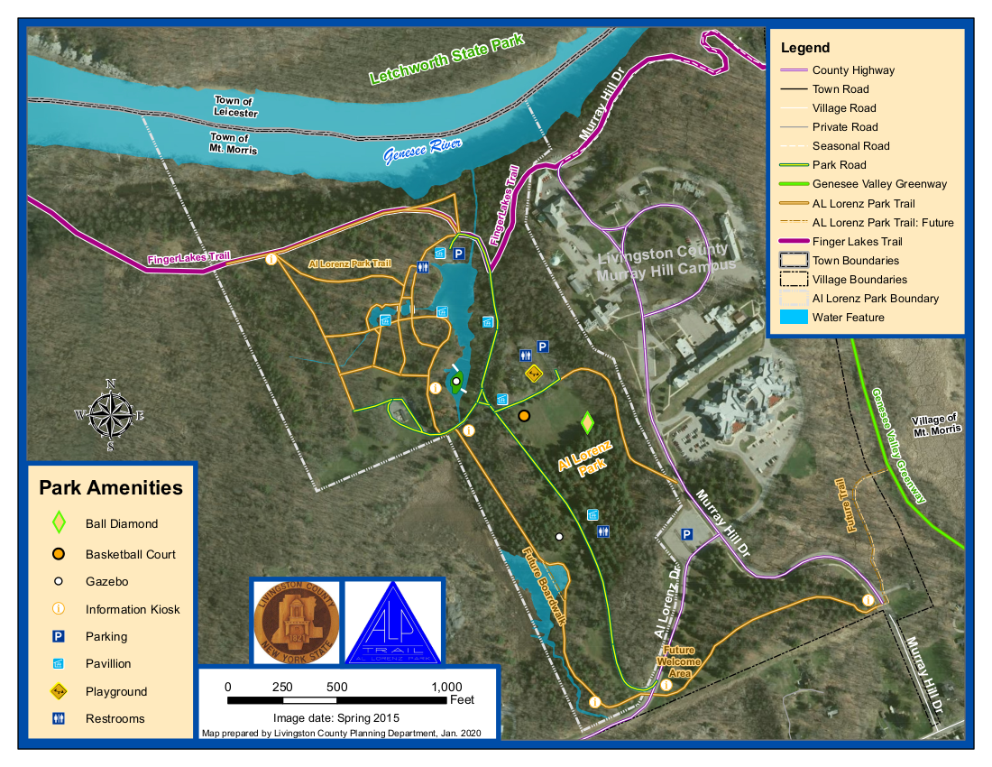
Since our last hike through the Al Lorenz County Park above Mt Morris, the county has made many improvements to the park, including new trails and beautiful bridges across the streams feeding the large pond. In honor of the opening of the summer season at the park, this Sunday’s hike will provide all hikers an opportunity to see more the park in person.
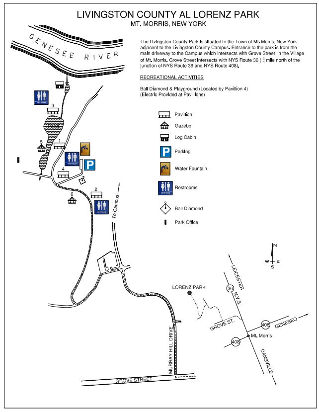
All hikers and bikers will meet at the parking lot behind Pavilions 4 and the playground (click on the map to the left for details). Following the hike and bike ride (around 4:30), we will meet at Pavilions 3 at the end of the Pond for a dish to pass social (at that time we can move cars to the pavilion parking area).
Our hikers will follow the Letchworth branch of the Finger Lakes Trail along the gorge to the Mt Morris Dam, and then will return to the Park. The Climbers will stay on the Letchworth Branch (Yellow blazes) past the FLTC Office, the Dam Visitors Center to the overlook of the dam. Given time, they will continue on to enjoy addition views of the Letchworth gorge until the trail jogs left away from the river. Turning around at that point will result in a round trip hike of about 3.4 miles.
The Naturalists hike will also follow the Branch trail up to a field before the Dam area. This field contains a Wildlife Loop. Based on the condition of the wildlife loop and the time, the Naturalists will choose whether to hike around the loop or continue on to the Dam overlook. Turning around at the Dam overlook will be a 2.8 mile hike.
Bikers will head west within the park and climb a steep hill to the Livingston County Campus, and then will descend a curving road to the Genesee Valley Greenway. From there, we will follow the Greenway north to NY-20A. We will turn around and ride the Greenway (or possibly River Rd) back to Mt Morris, to Grove St, where we will turn south, following Grove St and Parker Rd. After turning right on Al Lorenz Dr, we will re-enter the park. If time permits, we will ride some of the park trails back to the Pavilion 3.
 When hikers return to the Al Lorenz park, they should take some time to explore the trails around the pond. Between 4:30 and 5:00, gather at Pavilion 3 for a Dish to Pass social. Please bring a dish to share and your own beverage, or bring a sandwich if you are more comfortable not sharing. A contribution to support the social supplies of $5 is appropriate if you forget or can’t bring your food contribution.
All hikers and Bikers will meet at the parking lot behind Pavilions # 4 and the playground. Please be ready to start the hike or ride at 2:00.
Directions
From Springwater and Wayland: (Note that Liberty Pole Rd is under construction. These directions avoid Liberty Pole Rd). Head south on NY-15 through Wayland. Turn right onto I-390 past the Dansville exits to Exit 6 (16.3 mi) for NY 36, Mt. Morris. Turn left on NY-36N for 5.4 miles. At the third left following the lights at NY-408 turn onto Grove St. In 0.2 miles turn right onto Murray Hill Rd. At the top of the hill, turn left on Al Lorenz Dr. In about 0.1 mile, enter the Al Lorenz Park. Turn right in about 0.3 miles to get to the parking lot behind Pavilion #4.
From Rochester: Take I-390 S to Exit 7 for NY 408 Mt Morris. Turn left (south-west) on NY 408. At the Main St light, turn right. At the third left on Main St, turn onto Grove St. In 0.2 miles turn right onto Murray Hill Rd. At the top of the hill, turn left on Al Lorenz Dr. In about 0.1 mile, enter the Al Lorenz Park. Turn right in about 0.3 miles to get to the parking lot behind Pavilion #4.