
Glen Haven Rd
Irondequoit NY
 A month ago we hiked in the Abraham Lincoln Park on the east side of Irondequoit. This month we are headed across the bay to Irondequoit Bay West Park. The terrain on this side is quite similar to the east side, but the park has a different feel, partly because it is open to mountain bikes. The extensive trail system is mostly maintained by the Genesee Regional Off-road Cyclists. Due to the season, we aren’t expecting to meet many cyclists, but please remember that we are enjoying the trails because cyclists have volunteered to maintain them.
Most of the trails we plan to follow are shared use trails, and all users should be aware of traffic. Cyclists are expected to yield to hikers who are hiking, but hikers who are enjoying the scenery should step aside for cyclists.
During our pre-hike, these trails were very easy to follow. The leaves had been swept from the trails and the trails were well used and smooth. The trails are only blazed at intersections, so be careful to check your trail each time you come to a crossing.
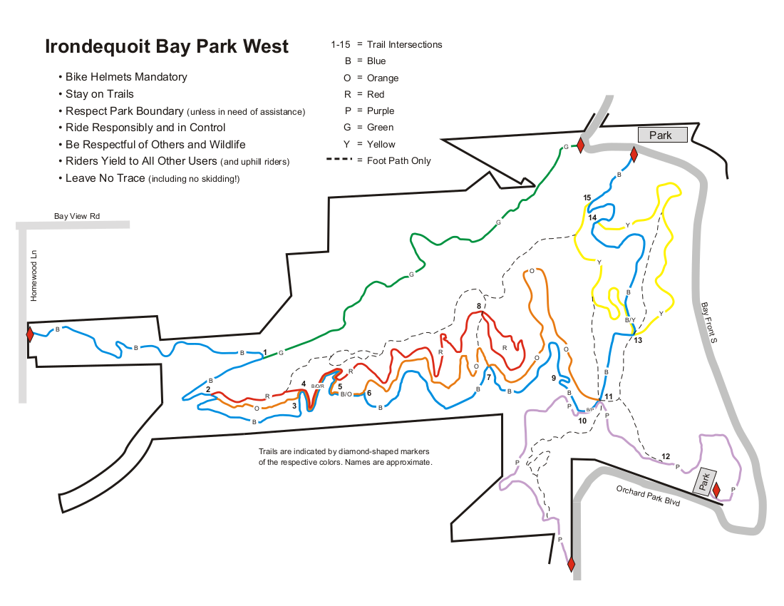
The are many ways to follow the trails. Below are suggestions for three length hikes. A PDF of all of the maps can be downloaded and printed. Please click on each map to the right for more details. 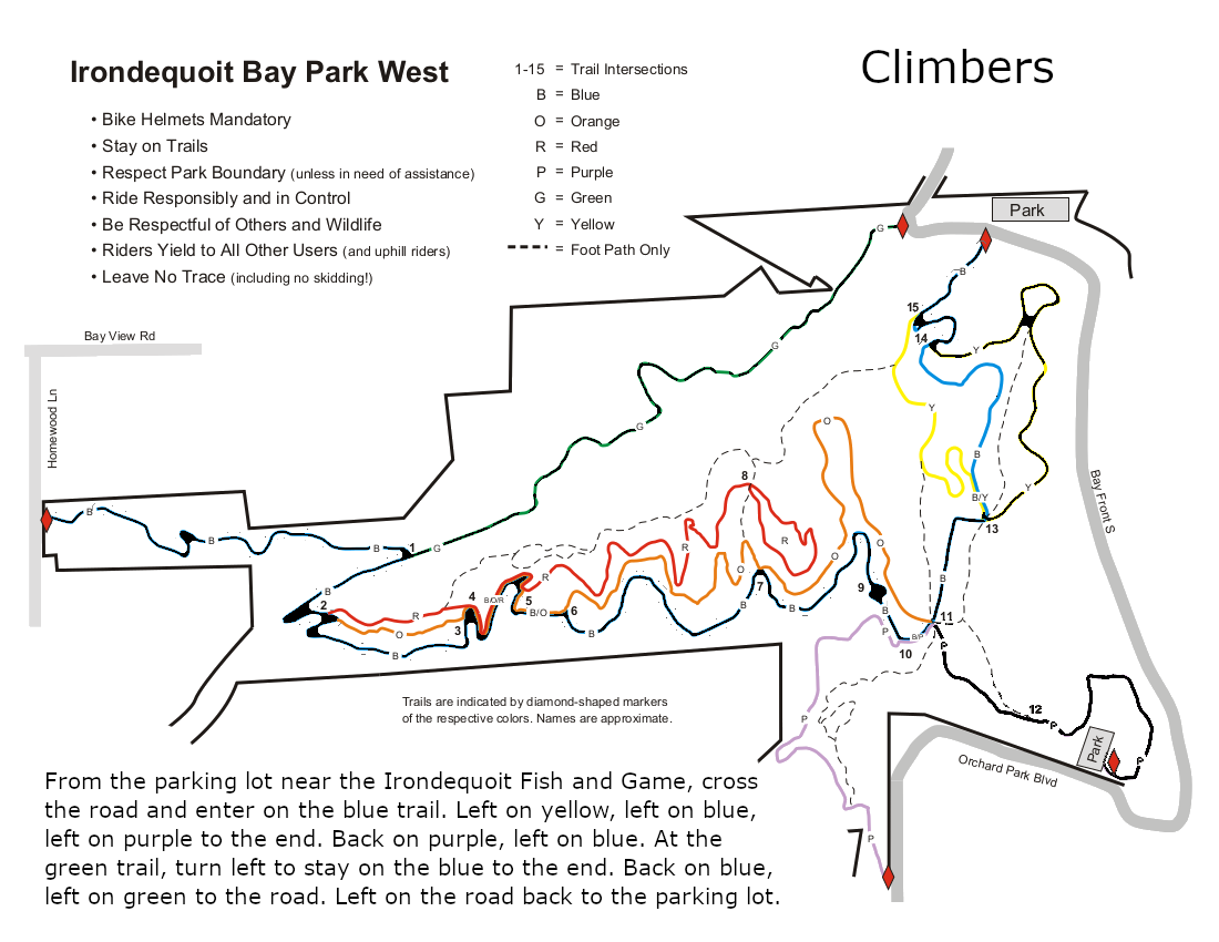
All hikers will meet on the north east side of the park where Glen Haven Rd enters the park. There is a small parking area at the sharp corner at the end of the Green trail, and a second larger parking area about 400 feet east on the left near the entrance to the Irondequoit Fish and Game store and across from the start of the Blue trail.
The Climbers will walk west on the road about 100 yards to enter the park on the green trail. This trail follows above an old path to cottages. All that is left of the cottages are the foundations to the right of the trail. The green trail ends at the blue trail near a bridge across the creek. Turn right on the blue trail as it climbs to the west side of the park. Trail maintenance has done a nice job on the bridges of this section. At the road, turn around and follow the same trail back down to the green trail. Turn right to stay on the blue trail The blue trail follows the southern edge of the park, parallel to the red and orange trails, so pay attention to the blazes if you want to stay on the blue trail. At intersection 11 (see the map) at the eastern side of the park, a purple trail leads down to the southern parking area. Based on interest and time, the Climbers will explore this trail, down and back. On returning to the intersection, turn right on the blue trail. At the next intersection, turn right onto the yellow trail for a pretty trip above the bay. When you return to the blue trail, turn right to return to the cars. (An alternate route follows a foot path up the hill between the blue and yellow trails for a view of the bay from on high!).
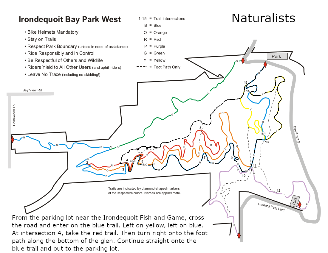
The Tourists and Naturalists will start on the blue trail directly across from the main parking area. At the first intersection, the yellow trail goes to the right and the blue trail heads up the hill. This is a good time to notice the blazes the you will see at every intersection. Stay on the Blue trail to the next intersection where you want to switch to the yellow trail to enjoy an overlook of the bay. The yellow trail will rejoin the blue trail and hikers will continue straight onto the blue. At this intersection, there are two steep trails up to the tops of the hills. These are not blazed and are for the use of hikers only (no bikes). Check the map if you would prefer to follow these trails.
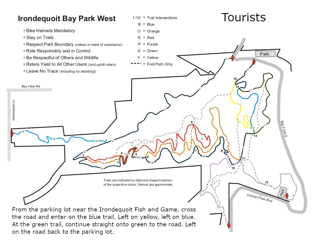 At the next intersection (with blue, purple and orange blazes), continue straight on the blue trail.
At intersection 4, the Naturalists will leave the blue trail to stay on the red trail for a very short distance and then turn right to follow a hiking only trail back to the cars.
The Tourists will stay on the blue trail until it comes to the green trail and then follow the green trail back to the road and the cars.
 With COVID and the early sunset, no social is planned following the hike. Hikers may want to explore the road along the bay to the south side of the park.
Please enjoy the holiday season and stay safe for your family and neighbors.
Directions:
From Springwater: Follow NY 15A or NY 15 north to I-390. In Rochester, merge right onto I-590 N. At the intersection with 490, stay left to continue on 590N. Take exit 9 for Bay View Rd. Turn left onto Bay View Rd, and take the 3rd right onto Glen Haven Rd. In less than a mile, you will enter the park (the road name changes to S Glen Rd and then to Bay Front S, but don’t worry about that). There are two parking areas within 400 feet of the entrance to the park.
From Naples: Follow NY 21 north to NY 64 in South Bristol, to US 20. Turn left on US 20, then in a mile, turn right on NY 444 to Victor. Turn left on NY 96. In 2.9 miles enter I-490. Use exit 21 for NY 590N. Take exit 9 for Bay View Rd. Turn left onto Bay View Rd, and take the 3rd right onto Glen Haven Rd. There are two parking areas when you reach the park.
From Canandaigua: Follow NY 332N to the Thruway west. Take exit 45 for I-490. Take exit 21 for NY 590N. Take exit 9 for Bay View Rd. Turn left onto Bay View Rd, and take the 3rd right onto Glen Haven Rd. There are two parking areas when you reach the park.