
Webbs Crossing Rd

FLT through Kanakadea Park. The FLT (shown in Black) is marked with White blazes on trees, signs or posts.
This Sunday we will follow the Finger Lakes Trail through the Kanakadea County Park west of Hornell. Last month we hiked south of Howard NY from Hughes Rd to Burleson Rd. The next section of the FLT starting at Spencer Hill Rd and ending on Lain Rd was led by Bill and Pam three years ago, and featured a social at the Cider Creek Cidery. In 2015, Linda led us on the section from Lower Glen Ave to North Hornell. For this FLT Series, we are going to skip to the west of Hornell and enjoy a recent route change for the FLT that takes advantage of park trails through Kanakadea Park. I will leave the previous two sections to leaders who would like to repeat a past hike.
A carpool to this hike will be available from the parking area behind the Firehall in Wayland. The carpool will leave promptly at 1:15. Following our hike, we will return to Wayland for a Social at the “Belt in the Eye” Diner.
All hikers will meet at the Parking lot in Kanakadea Park. The Climbers and Tourists will carpool a mile farther down Webbs Crossing Rd to a FLT trail-head parking lot.. We will assign leaders of the Climbers, Tourists and Naturalists at the hike depending on the requested groups.
NOTE: The portion of this hike south of the interstate is fairly flat and would be easy walking in dry conditions. With snow on the soft ground, walking will be slower and more difficult. Traction devices are encouraged, as are walking sticks. The section north of the interstate is a series of steep ups and downs. Special care to avoid slipping will be needed. In addition, the tunnel under the interstate is long and dark. A flashlight or headlamp is recommended for the Tourists and Climbers. As usual, dress in layers and carry water.

Naturalists will leave directly from the Park lot.
The Naturalists will start from the Park lot and head toward the lake to find white blazes for the FLT. Note that the road goes down to the water, while the trail stays along the edge of the high ground. Follow white blazes through wood and then up and across a field to the park’s Nature Trail. Once on the Nature Trail bear right to stay on the FLT. Once the trail comes out onto a field, hikers may decide to turn around and re-enter the Nature Trail. Following another section of the Nature Trail will return you to the parking area. Based on time, the Naturalists may follow the park road a short distance out of the parking lot, then turn left to continue on the FLT through the campgrounds. Naturalists are encouraged to leave the trail and explore near the lake.

The Tourists will cross Webbs Crossing Rd and follow the FLT within Kanakadea.
The Tourists will carpool to the FLT parking lot on Webbs Crossing. They will start with the Climbers heading out the back of the parking area uphill toward I-86. This will allow the Tourists to see the long tunnel under the highway before turning around and returning to the parking lot and starting to hike toward the Kanakedea Park. Carefully cross Webbs Crossing Rd and follow the white blazes on a mowed path parallel to the road. There is one section that isn’t blazed, but the trail goes to the left and is easy to follow to a gate to the park. (You can first go to the right and walk down to the lake – then return to the intersection and continue). Continue on the park road (there are occasional blazes on posts and the backs of signs). Turn right at the main park road and continue to the cars. As time permits, the Tourists can continue on the Naturalists route to the Nature Trail. [NOTE: If the tourists would prefer more climbing, but a shorter hike than the Climbers, they can follow the Climbers through the tunnel and around the loop, ending their hike at the FLT parking lot. If they do this, be sure to have keys to the cars so you can return to the park after the hike.
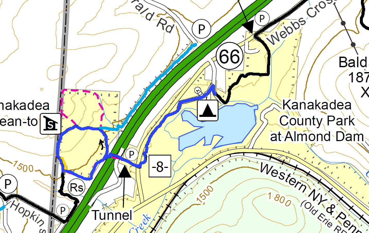
The Climbers will pass through the Tunnel and loop around back the the Tunnel, before following the Tourists through the park.
The Climbers will carpool with the Tourists to the FLT parking lot on Webbs Crossing. They will start uphill through the tunnel to the Senaca County Park on the other side of the highway. At the end of the fences, Climbers will turn right and follow the White blazed FLT. We will pass a Blue spur trail and later the Kanakadea Lean-to each on the right. About 0.3 miles after the Lean-To, we will see large yellow blazes and will leave the FLT when the yellow blazes go off to the left. After returning through the tunnel, we will follow the Tourist route to the Park and the waiting cars.
Directions to Carpool at Wayland Parking (42.568606, -77.590562):
Plan to be at the parking area at 1:00. We will leave at 1:15 for Hornell.
From Springwater: Head south on NY-15 to the light in Wayland. Turn right on Rt 63 (W Naples St). In about 150ft, turn right between the Fire House and the Sugar Creek building to get to the parking lot in the center of the block.
From Dansville: Head east on Rt 63 toward Wayland. Just before the second light in Wayland (at NY-15) turn left between the Fire House and the Sugar Creek building to get to the parking lot in the center of the block.
From Naples and N Cohocton: Head west on NY-21S toward Wayland. Go through the light at NY-15. In about 150ft, turn left between the Fire House and the Sugar Creek building to get to the parking lot in the center of the block.
Directions to Hike
From Springwater: Head south on NY-15. In Wayland, continue south on NY-21 and stay on 21 for 16.6 miles. Just before Hornell, turn right on CR 66 (Webbs Crossing Rd). (If you miss CR 66, turn right on Airport Rd, or NY-36 N and then take the first left onto CR-66). Continue for 2.5 miles. Turn left into Kanakadea Park. At the fork, stay to the left to the parking lot.
From Dansville: Head south on NY-36 past Stony Brook. In 14.5 miles, pass under I-86 and take the first right onto CR-36. In 2.2 miles, turn left into Kanakadea Park. At the fork, stay to the left to the parking lot.
From Naples and N Cohocton: Head south on NY-21S. In N Cohocton continue straight onto NY-371. At the stop sign in Cohocton, turn right onto Maple Ave. In a half mile, turn left onto Cohocton Loon Lake. Continue straight past the entrance to I-390 where the road becomes CR-121. In 4 miles, turn left onto NY-21. Just before Hornell, turn right on CR 66 (Webbs Crossing Rd). (If you miss CR 66, turn right on Airport Rd, or NY-36 N and then take the first left onto CR-66). Continue for 2.5 miles. Turn left into Kanakadea Park. At the fork, stay to the left to the parking lot.
Directions to Social
Head back toward Hornell on CR-66. Turn left onto NY-21N for 18 miles. In Wayland at the light, turn left on W Naples St, then right onto N Main St. The restaurant is on the right. You can park on Main St, or in the parking area where the carpool started. From the carpool parking, walk out the west entrance to Main St and turn left for the diner.