
Canisteo
NY 14823
USA
Colorful Foliage and Tasty Fresh Cider on NY’s Signature Trail
Please note: Bow hunting season is in effect for next Sunday’s hike. Please wear blaze orange or something colorful.
On Sunday, October 23, Springwater Trails will partake of two venerable central New York institutions: the Finger Lakes Trail and apple cider. Set in Steuben County a few miles south of Hornell, our hike on a section of the main FLT will take us through forests of colorful hardwoods as well as groves of pines and fields affording views of open country and rolling hills with nary a paved road in sight. Colors should have reached their peak by the time of our hike.
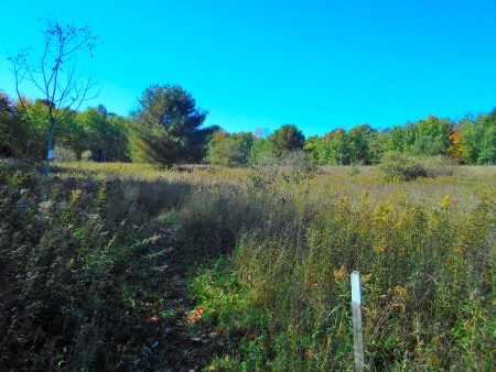
Finger Lakes Trail emerges from Burt Hill State Forest heading west
We have laid out three options for hikes, varying by length and difficulty. Regardless of the level that you choose, all of them are scenic and rewarding. Each hike ends at our gathering point – the Cider Creek Hard Cider cidery on Cunningham Creek Road.
Naturalists will enjoy a leisurely 1 mile hike eastward along the FLT. A shuttle will take you to the starting point on Laine Rd. The first half-mile follows Laine Road, a country dirt road where traffic should be minimal-to-non-existent. You then turn left into the woods from a well-marked sign to hike the remaining half-mile on a gradual descent to Cunningham Creek Road where the cidery awaits you on the right.
From the opposite direction, Tourists are hiking 2.4 miles in a westerly direction starting at Windfall Rd. Most of this hike is a gradual descent with one short upgrade in the last third. The steepness of the final descent to Cunningham Creek Rd. is ameliorated by the prospect of delicious fresh cider awaiting you at the cidery! Enjoy your libations while you await the Climbers whose 4-mile hike starts atop Spencer Hill, one of the highest points in Steuben County. Enjoying sweeping views for the first half-mile, we then walk along the edge of a field and enter Burt Hill State Forest. After descending to a small creek, a subsequent ascent takes you up to the ridgeline, passing a short side trail to the Burt Hill Lean-to en-route. This stretch through the state forest includes a beautiful pine grove as well as mixed hardwoods before we emerge in the open and reach Windfall Rd. From this point, our hike follows the Tourists route to the cider barn.
Please note that all three hikes described above include some rugged footing, primarily lots of protruding tree roots. The stretch from Windfall Rd. also contains mucky footing in some places.
Our social following the hike will be held at the cidery where, weather permitting, we’ll set up on picnic tables under a roof just outside the building. Please bring a dish to pass. There are no kitchen facilities available i.e. no oven, microwave, or refrigerator. However, there are outlets for crockpots and we’ll also have a Coleman stove set up for anyone who needs soup, stew, chili etc. heated up. You may bring a beverage but we encourage patronizing the cidery as they are very generous hosts in providing this facility for us. In addition to a variety of ciders – alcoholic and sweet – the cidery offers beer and wine. Ciders may be purchased to drink on premises (samplers of 4 kinds or glasses of your favorite) or take home in bottles or growlers.
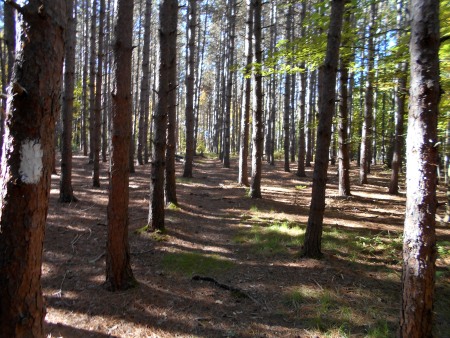
Red pines line the Finger Lakes Trail in Burt Hill State Forest
Logistics: We encourage car pooling and have designated the Shurfine Supermarket parking lot in Wayland as the location to meet at 1:00 PM. Plan to arrive at the cidery no later than 1:45 PM. This slightly-early meeting time will maximize enjoyment of our time on the trail. We will organize car shuttles at the cider barn and head to our starting points no later than 2:00 PM.
Directions: Take Rt. 21 south towards Hornell. After Rt. 36 joins 21, stay on 36, looking for signs to Main St. Turn left on Main St., following it (becomes East Main St.) out of town where it becomes County Rt. 109, also known as Turnpike Rd. In the country out of Hornell, you’ll pass Laine Rd. The next road is Cunningham Creek Rd. Turn right and reach the cidery in about 1.3 miles. The cidery’s barn is on the right but please park across the road (just after crossing the creek).
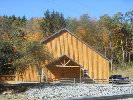
Cider Creek Cidery on Cunningham Creek Road
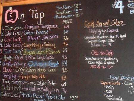
Cidery flavor board – some flavors may change