Posted on by

Maintaining the Bristol Trail, Tuesday, August 4, 8 AM

Did you enjoy the neat hike on the Bristol Trail on July 19?  Did you notice the work that’s needed to make it into a real neat trail, friendly not only for hikers, but also for the Twisted Branch mega marathon runners on August 29, many of whom will be entering this part of the trail in the dark?

So, grab your work gloves, loppers, weed eaters, bowsaws, etc. and join us on Tuesday, August 4 or, if it’s raining, the following day.  We’re starting at 8 AM, so we can get done before it gets too hot.  We’re meeting at the picnic tables outside Bob and Ruth’s in Naples, to plan our workday.  You can get a cup of joe, or anything else you’d like, from their fine breakfast menu.  Most important, you can use their plumbing facilities, to start out with an empty storage tank.  Donna Noteware is meeting us there, to get us access to the middle of the trail, through Longsdorf Rd.  This is where those omnipresent multiflora roses are constantly encroaching on the trail

Hope to see you there.  Let’s show how nice our organization can make this trail for our hikers and runners.

Posted on by

Crescent Trail “Way Finding” signs

The Crescent Trail recently started a new project to improve the blazing of the Crescent Trail in Perinton.  As we continue to build and blaze the Springwater Trail, I thought the Trail Committee should keep up with other organizations and how they blaze the trails.  The article below is copied exactly from a PDF posted on the Crescent Trail Yahoo Group.

By the way.  If you would like to be a member of the Springwater Trails Trail Committee, working with our Trail Master (Rick Henchen) to plan and build the Springwater Trail, please contact any board member or send an email to [email protected].

New Way Finding Signs on the Crescent Trail

December 3, 2014

The Crescent Trail Association is beginning to install way finding signs on some sections of the trail system to help hikers keep on their intended paths. At this time we are producing signs that are simply colored arrows to point the direction of CTA trails at junctions and other locations where a hiker might wonder which way to go. Signs near access points to the trail system will have the Crescent Trail logo attached for identification. Dave Schaeffer came up with the concept and design of these new signs.

About 250 potential sites for signs on our 38+ mile system have been identified, so this will be a long term project. Signs at the more prominent locations, e.g. at trail parking lots, will be initiated by the Perinton Parks Department. CTA will concentrate on the way finding signs within the system.

The Horizon Hill area between Garnsey Road and Woodcliff Drive has several branches of the Crescent Trail system and many others, which have been the source of confusion for many first –time and even regular users, so our first priority for sign installation is there. As of this date, twelve signs have been installed in that area, with several more to come as weather permits.

Here are examples of some of the new signs:

WayFindingSignsJim Unckless, CTA Board Member

Posted on by

Expanding the Northeast Section of the Springwater Trail – Reynolds Gull Area Road Hike – October 26, 2014

It occurred to me this past week that Springwater Trails could expand the development of our original plan for a 32 mile continuous trail around Springwater.  While being a trail angel for a long distance hiker named Chosen, I had the opportunity to help navigate her trek through the area of Swain on the Finger Lakes Trail and Franklinville on the North Country Trail.  Due to hunting season, obstacles and closures on the trail, I followed her by car around the back roads of Allegany and Cattaraugus County, enabling her to complete a day distance trip of 22 miles on state forest trails and dirt or paved roads without carrying her full backpack.  It’s called “slackpacking,” a benefit that hikers have when they have a trail angel to provide support services.

ProposedRoute Fall 2012
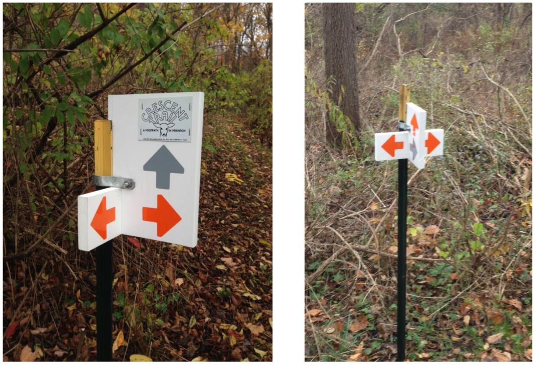
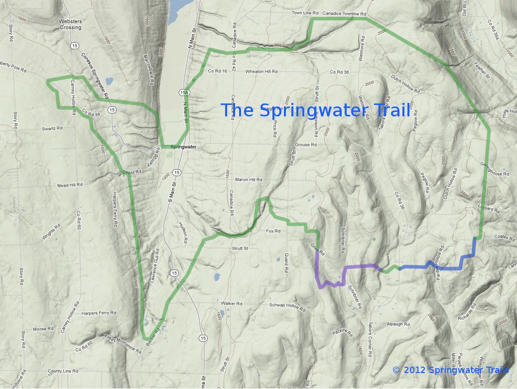
On the local level, this experience with a long distance hiker expanded my hike planning to taking a look at our original plan of a continuous 32 mile trail around Springwater.  The idea of the trail around Springwater was developed a few years ago by an original committee called Springwater Parks and Trails.  Using this background information, our president Mark designed a large scale map of where the trail could possibly be located. To date we have 4 trail areas in progress, 3 with landowners permission and one on state land.

FLT Connections
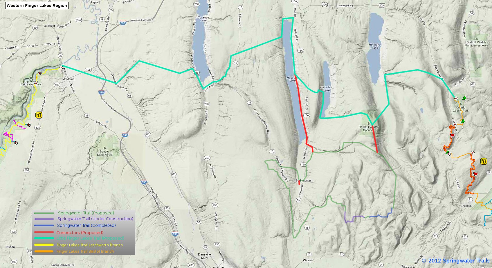
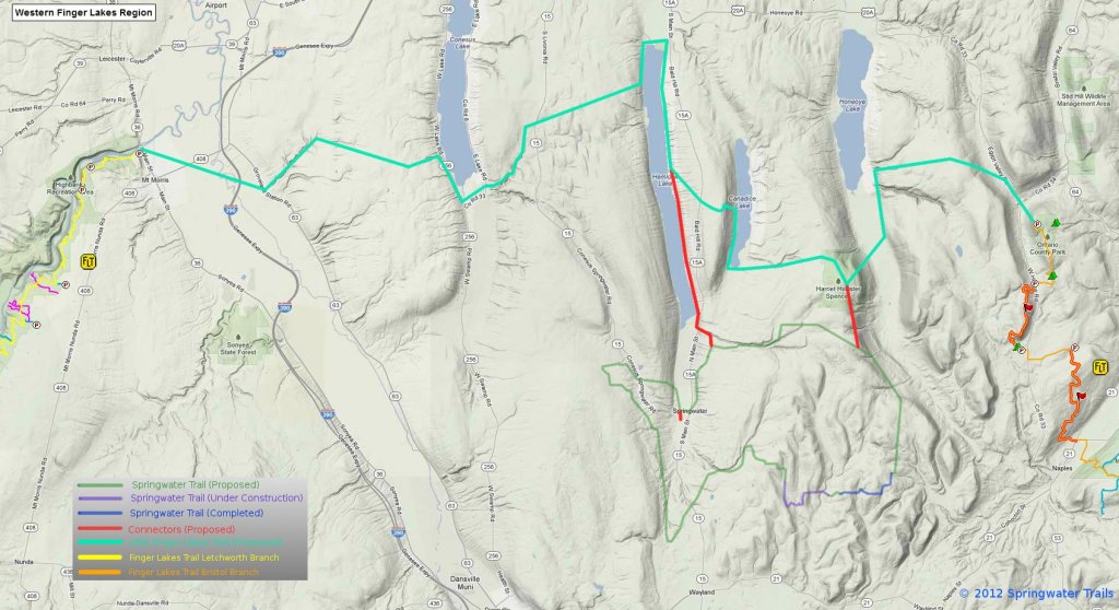
The proposed “master plan” in the northeast  section of Springwater accesses Harriet Hollister State Park to the north in Canadice to the newly acquired  state park property on Wetmore Road, following Town Line Road westward near the Nature Conservancy areas to a dirt road called Reynolds Gull Road.  The trail  would then drop unto Canadice Lake Road, hopefully accessing some private property someday and connect with the DEC Hemlock/Canadice State Forest at Johnson Hill. Once reaching the large parking lot Rt. 15A, hikers could continue hiking the south boat launch trail to Hemlock Lake, or access  the Village of Springwater to the south to explore the western part of the town.

13 hikers this past Sunday traveled the proposed route, starting at 2000′ and dropping to 1000′.  Two cars transported 10 hikers and two dogs to the top of Reynolds Gull Road while 3 hikers leisurely enjoyed hiking the Johnson Hill Trail, crossing the top of a dry waterfall.  Long distance hikers completed 6 miles in 2 hours exactly.  They picked up speed as they walked paved and dirt roads, accessing a DEC grassy trail off Johnson Hill Road which provided scenic views of fall trees, Hemlock Lake, steep gullies and waterfalls.  Reynolds Gull Road alone is a beautiful road to walk and the waterfall on the Johnson Hill trail is spectacular most of the year, especially in the winter and spring.

After the hike we warmed ourselves by the campfire at Pati and Jim’s, where a delicious roasted ham was prepared by Jim, healthy meals by others, and even 3 desserts! Thanks go to Pati and Jim for hosting our social and to Chosen for her inspiration and education.

Posted on by

How to share a hike location on Bing Maps

When you plan a hike, it is very useful to tell people how to get to the hike. This is very easy using Google maps, Bing maps or probably your favorite mapping website.

There are three ways to help people find the hike.  Our most common is to write out turn by turn directions from Springwater and other towns.  The second is to provide a link to one of the mapping websites and help get directions to the correct point.  Third is to provide the GPS coordinates that can be entered into a car’s GPS.  Providing all three allows each person to select the appropriate technology.

In Bing maps, click on Share to see a link.  You may need to click on "show full URL" to see the latitude.  Click on this picture for a larger version.

In Bing maps, click on Share to see a link.

Bing seems to be a little more obvious than Google for this task.  Since Gene could not make the Google directions work, I suspect others also had trouble.  So here are step by step directions for Bing.

  1. Browse to bing.com/maps.
  2. Enter an approximate location for the hike in the search box.
  3. Browse the map to find the exact spot where you want to meet.  Use Bird’s eye (or click the dropdown to the right of Bird’s eye) to select aerial – find the best for you internet speed) to place the position exactly.
  4. Switch back to Road view.  To get a GPS coordinates, click on the trail head and press the right mouse button.  You can then highlight the grey area and press CTRL-C to copy the coordinates.
  5. Click on “Share” to get a link to this view. Click on “Show full URL” to get the detailed address.
  6. Highlight the link, press CTRL-C to copy and paste the link into an email.

Google Maps directions

Get a link to your Google Map.

Get a link to your Google Map.

The following directions for Google Maps work in the Chrome browser on Windows 7.  It is probably similar for you.

  1. Browse to maps.google.com.
  2. In the search box, type the approximate location of the hike. For example, enter Springwater, NY.
  3. Browse the map to find the exact spot where you want to meet.  Trail heads are usually visible on the Satellite view if you zoom in far enough.  If you have a slow internet connection, you may want to get close using the Map view before switching to satellite view
  4. Once you find the meeting spot, point to it with your mouse and press the “right mouse” button to get a context menu.  Select “directions to here”.
  5. This will give you directions from the approximate location you entered to the real location.  To help the person you are sending the link to, you can remove the approximate location by highlighting and deleting the From address.
  6. Click the “chain” icon (see the red circle in the picture above) and press CTRL-C to copy the link.  Then paste the link into an email and send it off.

The link will look like https://maps.google.com/maps?daddr=Canadice+Lake+Rd&hl=en&sll=42.699674,-77.567296&sspn=0.011575,0.017424&geocode=FciWiwIdHHJg-w&t=h&mra=ls&z=16

Clicking on the link will show the map the way you had it.  So this is a good way to share.  Also, the longitude and latitude is right there (42.699674,-77.567296) if you have a GPS.v=2&cp=42.669683~-77.585483 &lvl=13&dir=0&sty=r& rtp=adr.~pos.42.702303_-77.566199 _near%206615 %20Canadice%20Lake%20Rd%2C %20Springwater%2C%20NY%2014560___a_ &mode=D&rtop=0~0~0~&form=LMLTCC.