An Introduction to New Zealand

New Zealand is made up of two main islands and a number of smaller islands in the South Pacific, near the centre of the water hemisphere, the half of the planet’s surface with the most water and the least land. In the image below you can see New Zealand to the right of Australia and above Antarctica. Hawaii is at the top edge just right of center, and the west coast of the USA is just over the horizon at about two o’clock. Because of its remoteness, NZ was one of the last lands to become settled by humans.

waterhemi

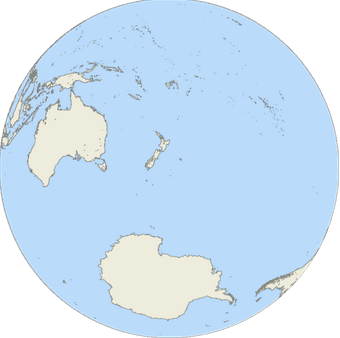
The Water Hemisphere

New Zealand is about a thousand miles long along its (mostly) vertical axis, with an area about equal to New York State and Pennsylvania combined. Texas is more than twice as large in area. The population is about 4.5M, roughly a quarter as many people as live in New York State. The population density is about 45 people per square mile, about half that of the USA, but four times more dense than Australia or Canada.
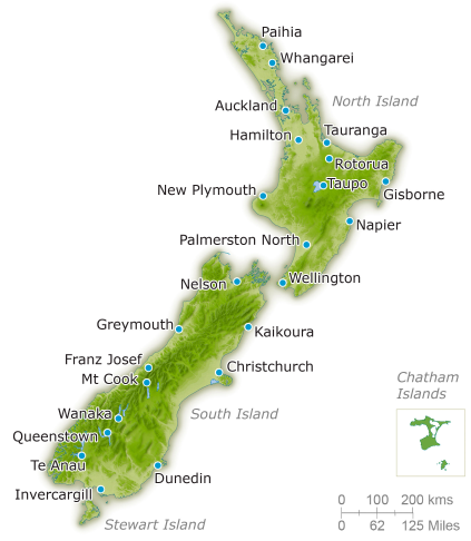
NZmap

New Zealand

The North Island has about 40% of the land area of New Zealand, and about 77% of the population. The larger South Island is dominated by the Southern Alps range of mountains extending 450 km north to south. The tallest peak is Mount Cook, the highest point in New Zealand at 3,754 metres (12,316 ft) and there are sixteen other points in the range that exceed 3,000 metres (9,800 ft) in height.

mtCook

Mt Cook


New Zealand owes its existence to tectonic uplift and volcanos. Lake Taupo on the North Island, sits in the caldera of a supervolcano which last erupted 1,800 years ago. This eruption is estimated to have been the most violent on earth for the past 5000 years. There is much geothermal activity, especially on the North Island, similar to that found in the vicinity of our own Yellowstone caldera.

Next up: the Finger Lakes of New Zealand

Add your own hike report to SpringwaterTrails.org

Members of Springwater Trails are always welcome to add their own information to the Springwater Trails website.  Hike planners write up a hike announcement which appears on the first page of the website.  Hikers who enjoyed a hike can post their own report telling interesting stories.

A couple of suggestions as you compose a post.  Avoid including last names, phone numbers and personal addresses.  The website is a public forum and this private information does not mix well. And, get permission before you post pictures of identifiable people. Also, any offensive posts will be immediately removed.

loginYour first step is to register on the website.  Click on “login” and then select register“register”.  Remember the password you choose.  I use 1password to store and recall all of my passwords.  Once you create a login, you can comment on any stories on the website.  Before you can create a new story, I need to set you up as a contributor.  If it takes too long, send me an email at [email protected].

On the website, hike announcements and reports are called posts.  You must log in to create a new post.

  1. When you log in, you will be placed on the dashboard.  If not, you will see a black bar at the top.  Under “Springwater Trails”, select Dashboard.  If the black bar isn’t available, try entering the address https://springwatertrails.org/wp-admin/.
  2. In the upper right corner you should see “Screen Options”.  Click on that and uncheck Quick Draft.  You don’t need to do this again, and you won’t be confused by the Quick Draft which we do not use.
  3. Click on Posts on the left menu, or, in the “At a Glance” area, click on the Posts link.
  4. This is where you will see your own posts.
  5. To create a new post, click on Add New at the top or on the left menu to add a new post.
  6. Type in a title.
  7. Type in your story.  Think like a reporter.  Do you remember the five W’s of a good story?
  8. Include one or two pictures for interest.
  9. Help direct your readers to additional information with hyperlinks.
  10. The newletter articles are selected based on the category you assign.  So always make sure you select a category.  The following categories appear in the newsletter:
    1. Sunday hikes — for hike announcements prior to the hike.
    2. Hike Reports — for reports about the hike after the hike occurs.
    3. Education — for interesting stories that are educational.
    4. Recipes – share the recipe for the dish you brought to the social.
    5. Hints — Hints that other members may find useful.
    6. HowTo — Instructions
    7. Maintenance — Stories about how to plan and maintain hiking trails.
    8. Conditions — notices to hikers about trail conditions.
  11. You may set tags to help searches.  I usually do not.
  12. Set a featured image.  This will show up as a link to the story if the user is reading a different page of the newsletter.
  13. Leave the Format as “Standard”.
  14. If it takes you a few times to finish a story, you can Save Draft while you step away. Click on Publish or Submit for Review when you are ready to have the story appear on the website.  If you would like the story to appear at a specific time in the future, you can edit the publish date above the Move to Trash button.

Happy Holidays

Tis the season to wish you all the very best.  Merry Christmas, Happy Hanukkah, Enjoy the winter solstice, Happy New Year, safe travels, and our best wishes to you, your family and your friends.

On Sunday, Dec 15th, we will be hiking at Schribner Road followed by our annual Holiday Social.  Please join us and enjoy the snow on skis or winter boots.  And try not to eat too much.


Web_0271 Group


IMG_0066_Web


Web_Group


IMG_0270


tourists


IMG_0597_Web


IMG_0883_Web


DSC_4931


DSCN8233_Web


DSCN8522_Web


webN8715


Rattlesnake Hill


DSCN9056_Web


canadice-triathlon-018Web


029_Web

Tumble Hill Campground, Cohocton – Dec 22, 2013 at 2:00PM

The group will explore a new trail system at the Tumble Hill campground in Cohocton. Three trailheads have been located, so we will spend up to two hours hiking the trails that lead from them with a trail map developed by the campground management. The trails appeared relatively flat and wide as seen from the trailheads, so it is expected that this will not be one of the more strenuous hikes, but will be on the easy to moderate side of the scale.

The campground has a Recreation Hall which will be open and heated for the social, so bring something to drink and a dish to pass, or a contribution for the green plastic trash can on the table. Park and meet up in the area just inside the campground, near the Office.

Tumble Hill Campground & RV Park | 10551 Atlanta Back Road
Cohocton New York,14826 |Tel: (585) 384 5248 or (740) 641 3793

If coming into Cohocton from Wayland on SR415, continue through town and across the river until the intersection with SR371. Turn left (North) onto SR371 and go 0.4 miles to Atlanta Back Rd, just after crossing the river again. Turn left and drive 0.4 miles. Tumble Hill is on the left.

If coming from I390, take exit 2 and follow the signs to SR415. Proceed as if coming from Wayland as described above.

If coming into Cohocton from Naples through Atlanta via SR371, look for Atlanta Back Rd as you near Cohocton. It will be after the first Cohocton River crossing and before the second. Turn to the right on Atlanta Back Rd. Tumble Hill is on the left after approximately 0.4 miles.

tumblehillmap1

Cohocton from Wayland, Naples, and I390

Cohocton from Wayland, Naples, and I390